
Small River Lea
A named pale-blue watercourse follows the western edge of the park, with trees along both banks and small illustrated stones in the water.
ILLUSTRATED PARK MAP · P461
Fowley Mead Park, Longcroft Drive, Waltham Cross, Hertfordshire · United Kingdom
 Enlarge the map ↗
A SENSE OF THE PLACE
Fowley Mead Park is a family-owned residential park in the Lea Valley at Waltham Cross. Its setting combines park-home living with access to nearby towns and public transport links.
The map records the arrangement of homes and internal routes. It is presented as a residential site-map example, reflecting a different use from holiday accommodation or touring pitches.
LOOK CLOSER
A named pale-blue watercourse follows the western edge of the park, with trees along both banks and small illustrated stones in the water.
Closely spaced trees and shrubs frame the southern, eastern and northern edges, with a particularly substantial planted strip beside the river.
An unlabelled green area with repeated grass marks extends beyond the upper boundary planting. No recreational use is specified.
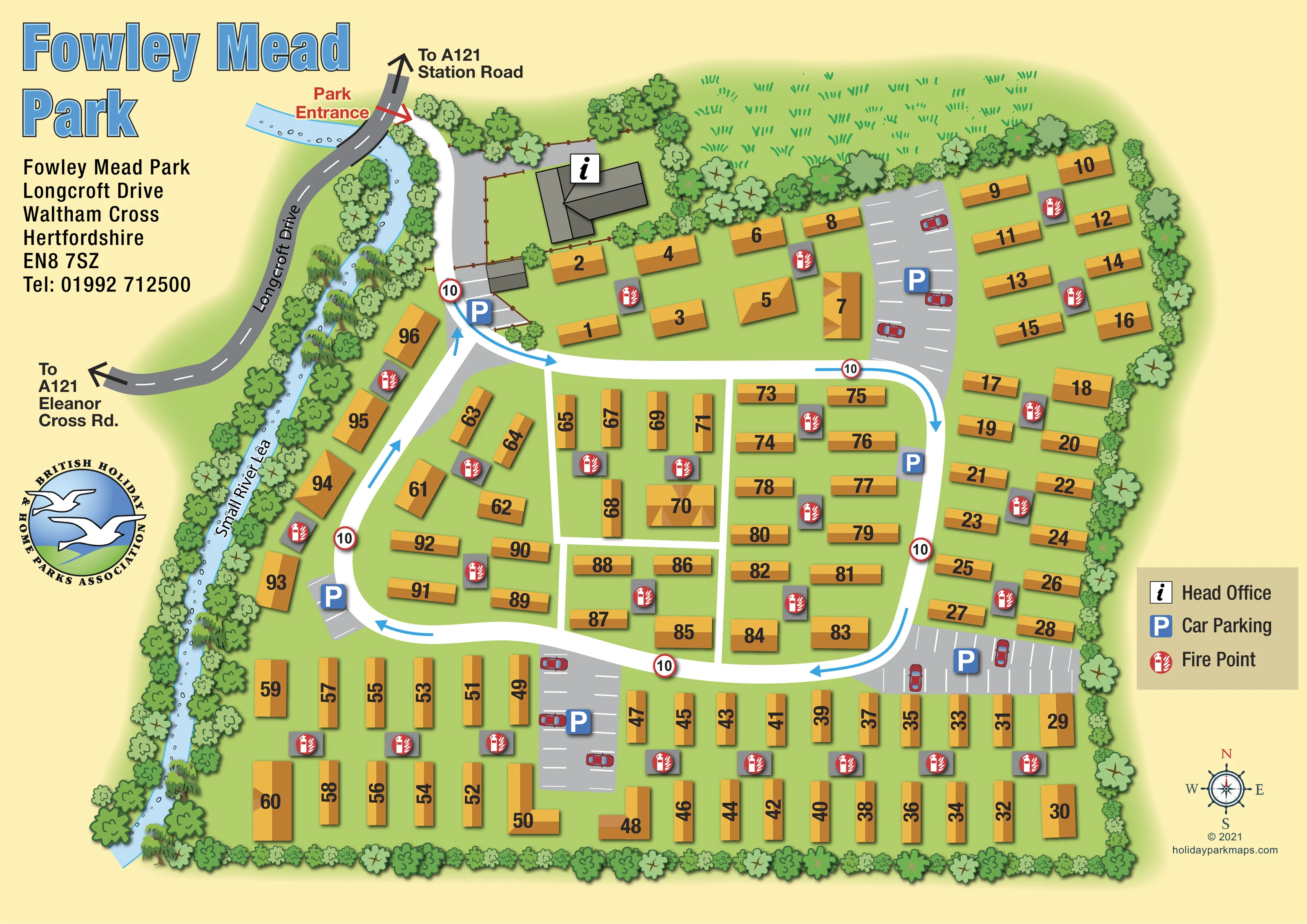
The legend identifies the information-style symbol as Head Office. It is placed over a substantial grey-roofed building within a fenced area near the entrance.
Grey parking areas with white bay markings and blue P symbols appear near the entrance and around the residential layout, including larger northern and southern parking courts.
Repeated red extinguisher symbols mark fire points throughout the home groups. The same symbol is explained in the three-entry legend.
A red label and arrow identify the entrance at the north-west corner, leading towards the office and internal route.
The grey external road is named Longcroft Drive. Off-map arrows point towards A121 Station Road and A121 Eleanor Cross Road.
The legend identifies the information-style symbol as Head Office. It is placed over a substantial grey-roofed building within a fenced area near the entrance.
Grey parking areas with white bay markings and blue P symbols appear near the entrance and around the residential layout, including larger northern and southern parking courts.
Repeated red extinguisher symbols mark fire points throughout the home groups. The same symbol is explained in the three-entry legend.
A named pale-blue watercourse follows the western edge of the park, with trees along both banks and small illustrated stones in the water.
Closely spaced trees and shrubs frame the southern, eastern and northern edges, with a particularly substantial planted strip beside the river.
An unlabelled green area with repeated grass marks extends beyond the upper boundary planting. No recreational use is specified.
A red label and arrow identify the entrance at the north-west corner, leading towards the office and internal route.
The grey external road is named Longcroft Drive. Off-map arrows point towards A121 Station Road and A121 Eleanor Cross Road.
A broad white loop links the entrance with the main residential groups. Blue arrows depict clockwise circulation, while narrower white connections divide the central groups.
Red-bordered circular signs displaying 10 recur along the internal route. The artwork does not state a unit alongside them.
READING THE MAP
This illustrated map of Fowley Mead Park presents a residential park-home community in Waltham Cross, Hertfordshire. Rather than organising holiday pitches or leisure facilities, it concentrates on the everyday task of finding a home, locating shared parking and understanding the site's internal routes. Approximately 95 homes are shown in compact rows and smaller groups, each identified by a prominent black number on a golden roof.
The Small River Lea gives the plan a distinctive western edge. Pale-blue water, varied trees and drooping riverside foliage contrast with the orderly home layout, while planting encloses much of the remaining boundary. Arrival from Longcroft Drive is highlighted in red beside the Head Office, and blue arrows trace the main circulation loop.
The page combines a large blue park title and address block with a simple three-symbol legend. It is a useful sample for residential park operators needing an illustrated site plan that balances individual property identification, practical wayfinding and recognisable landscape features.
The single landscape-format plan shows the residential layout within a planted boundary, with Longcroft Drive and the Small River Lea running along its western side. A red entrance arrow marks the north-west approach, close to a fenced Head Office area. The office is drawn as a substantial grey-roofed building and carries the information-style symbol defined in the legend. Directional arrows on the external road point towards A121 Station Road and A121 Eleanor Cross Road.
Inside the park, a broad white route forms a rounded loop around the central home groups. Blue arrows show clockwise circulation, and red-bordered signs displaying 10 appear at intervals. Narrower white connections divide the central blocks. The homes change orientation to suit their position: long parallel rows occupy the southern edge, paired rows follow the eastern side, and angled footprints respond to the river-side boundary in the west.
Golden yellow and ochre roof shapes keep the residential units visually consistent, while a few wider, hipped and L-shaped roofs provide variation. Large black numbers are the primary property-finding device. Grey parking courts, marked with white bays, blue P symbols and small red cars, sit among the home groups. Red fire-point symbols are distributed throughout the plan.
Landscape illustration gives the site its visual frame. Closely packed tree canopies line the boundaries, willow-like forms accompany the river, and grass marks texture the open area beyond the northern tree line. A large title, address block and association emblem occupy the left side of the sheet; the legend, compass rose and designer credit sit to the right. The enlarged views show details of this same artwork, not separate site sections.
KEEP EXPLORING
Chosen for shared landscapes, accommodation or facilities.
 Explore the map ↗
United Kingdom
Illustrated coastal campsite plan with named fields, electric pitch colours, beach routes and the Afon Hen.
 Explore the map ↗
United Kingdom
A woodland touring-park map with colour-coded pitches, a stream and footprint-marked walks.
 Explore the map ↗
United Kingdom
Colour-coded campsite map with riverside pitches, bell tents, a swimming pool and fishing lake.
Features may come from the sample artwork, its key or published park information. Approximate numbers describe the drawing and may cover only part of a park. They are intended to help you compare map examples. Current facilities and booking information should be checked with the park.
LET’S MAP YOUR PARK
For a map quotation, find your park and draw a rough boundary around it. The area you select helps us work out the design time and price.
Draw your park for a quote ↗Or talk to our map designers
01751 473136