
Tree-lined boundaries and planted divisions
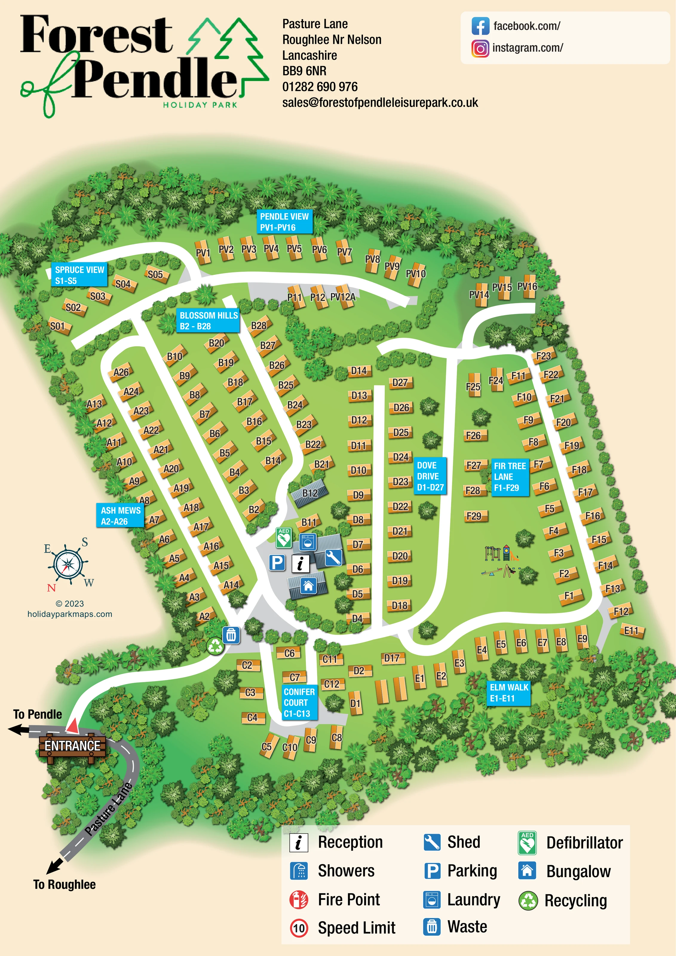
Dense illustrated tree belts surround the site, while hedges and smaller planting groups divide lanes and accommodation rows.
ILLUSTRATED PARK MAP · P126
Pasture Lane, Roughlee Nr Nelson, Lancashire · United Kingdom
 Enlarge the map ↗
A SENSE OF THE PLACE
Forest of Pendle Leisure Park is a small holiday home ownership park in Roughlee, Lancashire. Static caravans and lodges provide a base for exploring the surrounding countryside.
A children's play area and launderette are available on site. The neighbouring Bay Horse Inn offers a place to eat, and the map shows how the holiday home plots fit within this village setting.
LOOK CLOSER
Dense illustrated tree belts surround the site, while hedges and smaller planting groups divide lanes and accommodation rows.
Green ground areas separate holiday homes, accommodate the playground and soften the internal road junctions.
An information symbol identifies reception within the grey-surfaced central service cluster.
A blue parking symbol marks the arrival-side service area beside reception.
A washing-machine symbol marks a building in the central service cluster.
A blue spanner symbol identifies the shed beside the reception and laundry buildings.
A green AED symbol is positioned at the upper edge of the service cluster.
A house symbol identifies a separate grey-roofed building immediately below reception; its visitor accommodation status is not specified.
An information symbol identifies reception within the grey-surfaced central service cluster.
A blue parking symbol marks the arrival-side service area beside reception.
A washing-machine symbol marks a building in the central service cluster.
A blue spanner symbol identifies the shed beside the reception and laundry buildings.
A green AED symbol is positioned at the upper edge of the service cluster.
A house symbol identifies a separate grey-roofed building immediately below reception; its visitor accommodation status is not specified.
Waste and recycling symbols sit together on the entrance approach, below Ash Mews and beside the junction leading towards Conifer Court.
Illustrated swings, a slide and seesaw mark a grassy play space within the Fir Tree Lane area.
Showers appear in the key, but a separate shower symbol is not clearly located on the plan.
A red fire-point symbol is included in the key without a clearly visible corresponding location on the plan.
The key contains a red-ringed 10 symbol labelled Speed Limit; it is not clearly positioned on an internal road.
A prominent timber-style ENTRANCE sign and red triangular marker identify the turn into the park from Pasture Lane.
Black arrows at opposite ends of the illustrated Pasture Lane section indicate To Pendle and To Roughlee.
Broad white lanes form linked loops, curved branches and short terminal sections between accommodation groups.
Cyan panels identify Spruce View, Pendle View, Blossom Hills, Ash Mews, Dove Drive, Fir Tree Lane, Conifer Court and Elm Walk, each with an associated plot range.
Dense illustrated tree belts surround the site, while hedges and smaller planting groups divide lanes and accommodation rows.
Green ground areas separate holiday homes, accommodate the playground and soften the internal road junctions.
Park information identifies the neighbouring Bay Horse Inn as a place to eat; it is not labelled or illustrated on this plan.
READING THE MAP
This illustrated map of Forest of Pendle Holiday Park presents a leafy holiday-home setting in Roughlee, near Nelson in Lancashire. Gold-roofed accommodation symbols sit within a network of white lanes, framed by dense tree planting and divided into eight clearly named neighbourhoods. Bright cyan panels identify areas such as Blossom Hills, Ash Mews and Pendle View, making the overall arrangement easier to understand before visitors look for an individual plot.
The entrance from Pasture Lane is given particular emphasis, with a timber-style sign and arrows towards Pendle and Roughlee. Inside the park, reception, parking, laundry and other practical facilities are gathered around a central service area. A small illustrated playground adds a recognisable landmark within Fir Tree Lane.
The portrait page combines the site plan with prominent park branding, contact information, a compass and a substantial symbol key. It is a useful sample for holiday-home parks that need to explain a fairly dense layout while retaining the character of a landscaped countryside setting.
The plan begins at the lower-left entrance, where the grey, dashed-centre-line treatment of Pasture Lane contrasts with the park's white internal roads. Direction arrows point towards Pendle and Roughlee, and a large illustrated entrance sign makes the access point immediately recognisable. The approach curves past the waste and recycling symbols before reaching the central reception and parking area.
From this arrival zone, linked lanes organise the accommodation into distinct groups. Ash Mews follows the left boundary, with Blossom Hills occupying several rows beside it. Dove Drive forms the central run, while Fir Tree Lane wraps around the right-hand portion of the park. Conifer Court and Elm Walk sit across the lower area, and Spruce View and Pendle View occupy the upper edge. Each neighbourhood has a cyan name panel with a plot range, supported by individual letter-and-number labels on the accommodation symbols.
The service cluster is drawn with grey hardstanding and ribbed blue-grey roofs. Icons identify reception, parking, laundry, a shed, a bungalow and a defibrillator. Farther right, swings, a slide and a seesaw illustrate the children's play area directly within the green space. The bottom-right legend explains these symbols and also includes showers, a fire point and a speed-limit symbol.
Repeated tree canopies build a dense perimeter, with hedge-like planting separating some roads and rows. Gold roofs, pale labels and soft shadows keep the units distinct against the green ground. The single portrait artwork is topped by the park logo and contact block; a compass, designer credit and large key complete the page without separate inset plans.
KEEP EXPLORING
Chosen for shared landscapes, accommodation or facilities.
 Explore the map ↗
United Kingdom
Woodland-framed Barnsoul map with mixed accommodation, shared facilities and paw-marked walking routes.
 Explore the map ↗
United Kingdom
A wooded, streamside park map with a linked farm, café, touring and cottage area.
 Explore the map ↗
United Kingdom
A colour-zoned coastal park map with touring areas, woodland trails, ponds and a leisure club.
Features may come from the sample artwork, its key or published park information. Approximate numbers describe the drawing and may cover only part of a park. They are intended to help you compare map examples. Current facilities and booking information should be checked with the park.
LET’S MAP YOUR PARK
For a map quotation, find your park and draw a rough boundary around it. The area you select helps us work out the design time and price.
Draw your park for a quote ↗Or talk to our map designers
01751 473136