
Woodland and planted boundaries
Dense illustrated tree cover forms a broad northern backdrop and wraps much of the perimeter, with additional planted pockets between home groups.
ILLUSTRATED PARK MAP · P132
Gawthorpe Edge Park, Padiham Road, Burnley, Lancashire · United Kingdom
 Enlarge the map ↗
A SENSE OF THE PLACE
Gawthorpe Edge Park is based at Padiham Road, Burnley, Lancashire. The operator describes shops and bus services in nearby Padiham and access to Burnley and the M65.
Homes have mains gas, water and electricity; residents can choose their supplier. 15-acre grounds adjoin National Trust Gawthorpe Hall woodland. This is a residential retirement park with 105 homes.
LOOK CLOSER
Dense illustrated tree cover forms a broad northern backdrop and wraps much of the perimeter, with additional planted pockets between home groups.
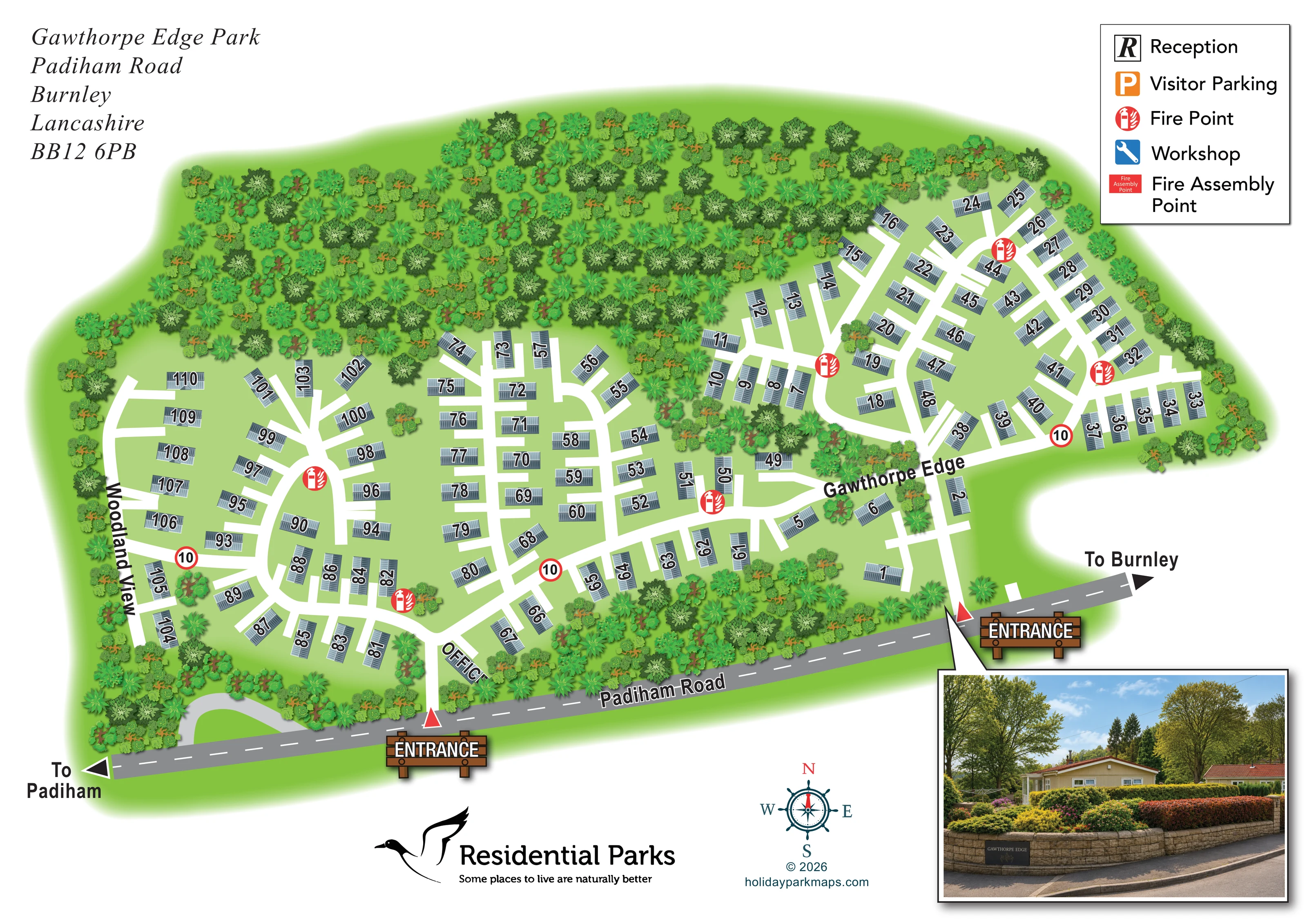
A building labelled OFFICE stands beside the western of the two labelled entrances from Padiham Road.
Red circular fire-point symbols are distributed around the internal road network in both residential sections.
Two access points from Padiham Road are emphasised with red triangular markers and illustrated wooden ENTRANCE signs.
The grey road runs along the lower edge of the plan, with arrows labelled To Padiham on the left and To Burnley on the right.
Gawthorpe Edge labels the main connecting route through the lower centre and eastern section; Woodland View labels the western perimeter route.
White internal roads form linked loops and branching lanes, with short approaches leading towards individual homes.
Red-bordered circular markers bearing 10 appear at several points on the internal roads, visually resembling speed signs.
A building labelled OFFICE stands beside the western of the two labelled entrances from Padiham Road.
Red circular fire-point symbols are distributed around the internal road network in both residential sections.
The key includes a boxed R for reception, but no matching R is clearly placed on the plan. The separately labelled office should not automatically be equated with it.
An orange P appears in the legend; a corresponding parking position is not clearly marked on the plan.
The legend includes a blue spanner symbol for a workshop, without a clearly plotted matching symbol.
A red rectangular fire assembly point symbol is explained in the key, but its location is not clearly shown on the plan.
Dense illustrated tree cover forms a broad northern backdrop and wraps much of the perimeter, with additional planted pockets between home groups.
Two access points from Padiham Road are emphasised with red triangular markers and illustrated wooden ENTRANCE signs.
The grey road runs along the lower edge of the plan, with arrows labelled To Padiham on the left and To Burnley on the right.
Gawthorpe Edge labels the main connecting route through the lower centre and eastern section; Woodland View labels the western perimeter route.
White internal roads form linked loops and branching lanes, with short approaches leading towards individual homes.
Red-bordered circular markers bearing 10 appear at several points on the internal roads, visually resembling speed signs.
READING THE MAP
This illustrated map of Gawthorpe Edge Park presents a residential retirement park on Padiham Road in Burnley, Lancashire. Around 110 park homes are shown within a green, tree-lined setting, with a substantial woodland backdrop across the upper part of the artwork. The emphasis is on finding a particular home and understanding the road layout, rather than locating holiday attractions or touring pitches.
Two entrances connect the park to Padiham Road, which is clearly labelled with directions towards Padiham and Burnley. Inside the park, white roads stand out against the grass-green ground, linking curved residential loops and short approaches to individual homes. Large roof-top numbers and the road names Gawthorpe Edge and Woodland View help readers move from the overall plan to a specific address.
The page combines practical mapping with recognisable details of the place. Illustrated wooden entrance signs draw attention to arrival points, while a photographic inset shows homes, mature trees and colourful planting beside the roadside entrance. An address block, symbol key, compass and Residential Parks branding complete the composition.
The single-sheet plan follows an elongated site outline, widening into a substantial western residential area and tapering into a more compact eastern section. Dense tree illustrations occupy much of the upper boundary, with further planting around the perimeter and between groups of homes. The two residential areas are connected by the route labelled Gawthorpe Edge; Woodland View follows the western side.
Homes are drawn as blue-grey rectangular roofs, each rotated to fit its position beside the road. Large black numbers with white outlines make the individual properties prominent. More regular rows occupy parts of the centre, while angled homes follow the curved western roads and the eastern perimeter. Broad white lanes and short individual approaches keep the circulation network visually separate from the green plots.
Padiham Road runs diagonally across the lower edge in grey, with a dashed centre line and arrows towards Padiham and Burnley. Two entrances are highlighted by red triangular markers and brown wooden-style signs. The office is labelled near the western entrance. Red circular fire-point icons are distributed throughout the residential areas, and red-ringed 10 markers appear on several internal roads. The upper-right key also explains reception, visitor parking, workshop and fire assembly point symbols, although corresponding locations are not clearly plotted for those entries.
Outside the main plan, the upper-left address uses italic serif lettering. Residential Parks branding occupies the lower margin beside a decorative compass and designer credit. A shadowed photographic inset at lower right is linked to the eastern entrance by a pointed callout, showing the landscaped roadside frontage. The composition balances a detailed numbered plan with a real-world arrival reference.
KEEP EXPLORING
Chosen for shared landscapes, accommodation or facilities.
 Explore the map ↗
United Kingdom
Illustrated coastal campsite plan with named fields, electric pitch colours, beach routes and the Afon Hen.
 Explore the map ↗
United Kingdom
A woodland touring-park map with colour-coded pitches, a stream and footprint-marked walks.
 Explore the map ↗
United Kingdom
A wooded Allerton park plan with colour-coded neighbourhoods, touring pitches and a central facilities hub.
Features may come from the sample artwork, its key or published park information. Approximate numbers describe the drawing and may cover only part of a park. They are intended to help you compare map examples. Current facilities and booking information should be checked with the park.
LET’S MAP YOUR PARK
For a map quotation, find your park and draw a rough boundary around it. The area you select helps us work out the design time and price.
Draw your park for a quote ↗Or talk to our map designers
01751 473136