
Tree and shrub boundaries
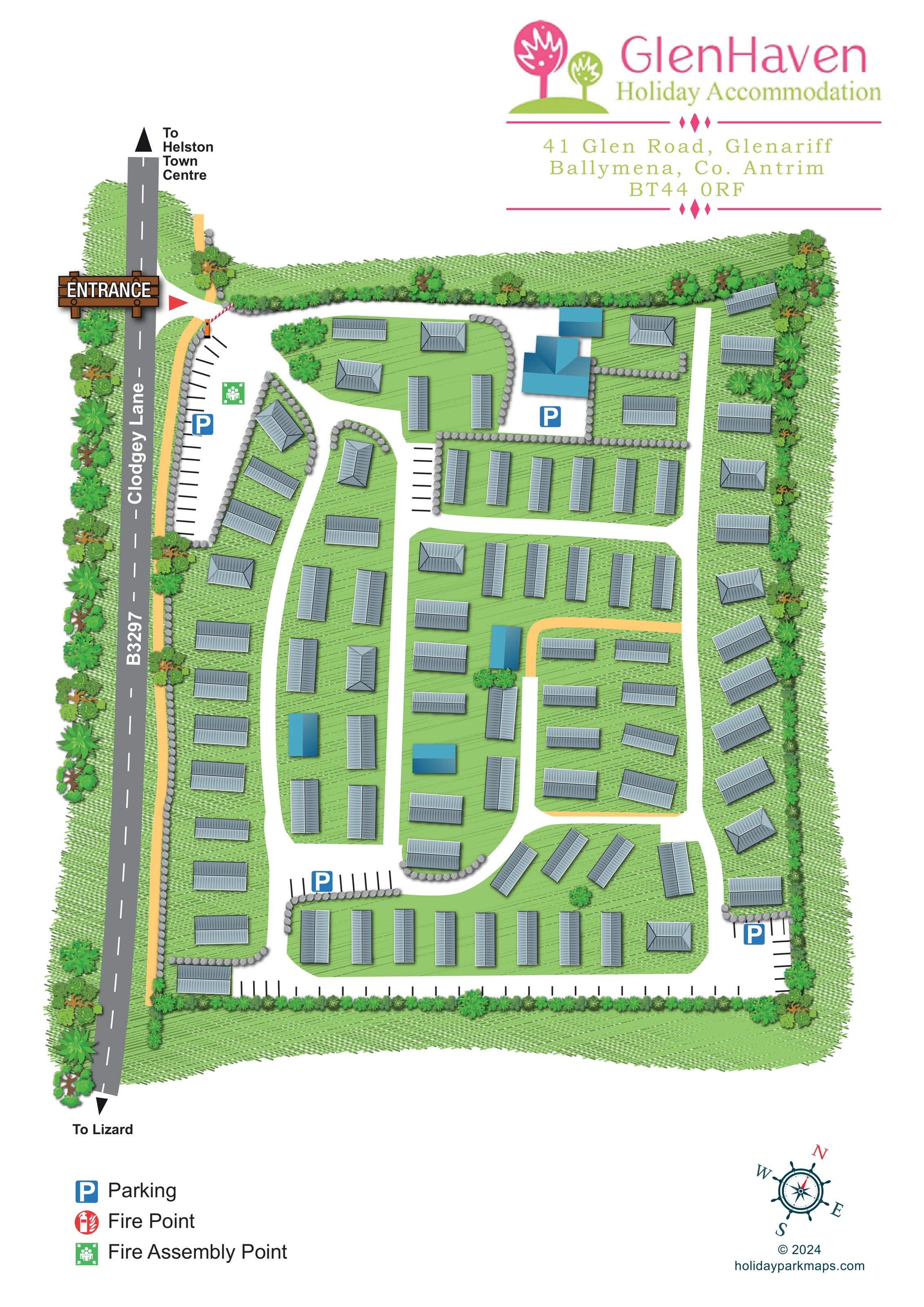
Dense illustrated trees, shrubs and palm-like foliage frame the site, with smaller planted clusters inside the accommodation areas.
ILLUSTRATED PARK MAP · P135
41 Glen Road, Glenariff, Ballymena, Co. Antrim · United Kingdom
 Enlarge the map ↗
A SENSE OF THE PLACE
GlenHaven offers group and family self-catering accommodation at Glenariff in the Glens of Antrim. The cottage has several en-suite bedrooms and two kitchen and lounge areas.
An enclosed children's play space and secure parking serve guests, with ground-floor access features described in the accommodation information. The location provides a base for exploring Glenariff Forest Park, the Causeway Coastal Route and the surrounding glens.
LOOK CLOSER
Dense illustrated trees, shrubs and palm-like foliage frame the site, with smaller planted clusters inside the accommodation areas.
Green, diagonally hatched accommodation islands are edged in places by rows of individually drawn grey stones.
An entrance on the upper-left boundary is highlighted by a timber-style ENTRANCE sign, red arrow and illustrated red-and-white lifting barrier.
The grey road along the left edge is labelled B3297 and Clodgey Lane. These labels conflict with the Glenariff address in the header.
Black arrowheads at the ends of the external road indicate Helston Town Centre and Lizard; these are directional references, not on-site destinations.
Broad white lanes form a perimeter circuit and several internal links, dividing the accommodation into elongated and rounded grass islands.
Blue P symbols mark parking near the entrance, beside the upper blue-roofed building group, at a lower internal junction and near the lower-right corner. Black bay markings also extend along parts of the lower boundary and internal lanes.
A green assembly-point symbol is positioned within the entrance-side parking area and explained in the legend.
An entrance on the upper-left boundary is highlighted by a timber-style ENTRANCE sign, red arrow and illustrated red-and-white lifting barrier.
The grey road along the left edge is labelled B3297 and Clodgey Lane. These labels conflict with the Glenariff address in the header.
Black arrowheads at the ends of the external road indicate Helston Town Centre and Lizard; these are directional references, not on-site destinations.
Broad white lanes form a perimeter circuit and several internal links, dividing the accommodation into elongated and rounded grass islands.
Blue P symbols mark parking near the entrance, beside the upper blue-roofed building group, at a lower internal junction and near the lower-right corner. Black bay markings also extend along parts of the lower boundary and internal lanes.
A green assembly-point symbol is positioned within the entrance-side parking area and explained in the legend.
A red fire-point symbol appears in the legend; no corresponding positioned symbol is clearly visible in the plan.
Yellow strips run beside the external road and around part of a central-right accommodation island. Their route type is not explained in the legend.
Dense illustrated trees, shrubs and palm-like foliage frame the site, with smaller planted clusters inside the accommodation areas.
Green, diagonally hatched accommodation islands are edged in places by rows of individually drawn grey stones.
A larger blue-roofed building group stands near the upper parking area, with several smaller blue-roofed structures elsewhere. Their functions are not labelled.
The supplied GlenHaven accommodation information mentions an enclosed children's play space; this is not identifiable in the illustrated plan.
READING THE MAP
This GlenHaven-branded sample presents a compact caravan-style site through a near-overhead illustrated plan. Rows of grey-roofed accommodation sit on green islands, linked by broad white lanes and enclosed by a dense border of trees and shrubs. The emphasis is on understanding the site's overall arrangement: where visitors enter, how the internal routes connect and where parking is distributed.
Arrival is particularly prominent. A timber-style entrance sign, red arrow and striped barrier draw attention to the upper-left access point, while blue parking symbols provide strong visual anchors throughout the plan. Stone edging, varied roof shapes and small planting clusters help distinguish neighbouring areas without relying on plot numbers.
The portrait page pairs this detailed site illustration with a spacious header carrying the pink-and-green GlenHaven identity. A short symbol key and decorative compass complete the composition below. As a design sample, it is useful for exploring how repeated accommodation units, several parking areas and a branching lane network can be made readable within a single visitor-facing map.
The single portrait artwork places the illustrated site beneath a large branded header, with an external road running down its left edge. At the upper-left entrance, a brown timber-style sign and red arrow lead the eye towards a red-and-white barrier. Just inside, an elongated parking area contains blue parking and green fire-assembly symbols.
White internal lanes divide the site into a series of grassed islands. Some are long and narrow, supporting parallel rows of accommodation; others have rounded or tapered ends that accommodate angled units. The lanes connect across the middle and lower parts of the plan, with an outer route following the right and bottom boundaries. Additional parking appears beside the upper blue-roofed building group, at a lower internal junction and near the lower-right corner. Black bay strokes extend beyond these symbol-marked areas.
Accommodation is drawn mainly as elongated grey-roofed units, with occasional broader hipped-roof forms. A larger turquoise-roofed building group near the top and several smaller blue structures offer contrasting landmarks, although their uses are unnamed. Rows of grey stones outline selected islands and parking courts. Dense trees, shrubs and palm-like foliage frame the perimeter, while diagonal green hatching gives the lawns a textured finish. Yellow route strips appear beside the external road and around part of a central-right island, without a legend definition.
The lower-left key explains parking, fire point and fire assembly point; the fire-point entry has no clearly visible plotted counterpart. A nautical-style compass balances the key at the lower right. The accompanying enlarged views are overlapping details of this same page, not separate site sections or additional accommodation.
KEEP EXPLORING
Chosen for shared landscapes, accommodation or facilities.
 Explore the map ↗
United Kingdom
Coastal park map with static-caravan rows, touring pitches, a camping field and two leisure clusters.
 Explore the map ↗
United Kingdom
A wooded Allerton park plan with colour-coded neighbourhoods, touring pitches and a central facilities hub.
 Explore the map ↗
United Kingdom
Illustrated coastal holiday-home plan with dense alphanumeric plot labels, orange-roofed amenities, a numbered facility key and beach-side context.
Features may come from the sample artwork, its key or published park information. Approximate numbers describe the drawing and may cover only part of a park. They are intended to help you compare map examples. Current facilities and booking information should be checked with the park.
LET’S MAP YOUR PARK
For a map quotation, find your park and draw a rough boundary around it. The area you select helps us work out the design time and price.
Draw your park for a quote ↗Or talk to our map designers
01751 473136