
Tree-lined grounds
Repeated circular tree symbols define much of the perimeter and smaller planted edges, with green ground extending between accommodation groups.
ILLUSTRATED PARK MAP · P478
Beach Road, Scratby, California, Great Yarmouth, Norfolk · United Kingdom
 Enlarge the map ↗
A SENSE OF THE PLACE
Green Farm Caravan Park is based at Beach Road, Scratby, California, Great Yarmouth, Norfolk. This is a family-run caravan park in landscaped grounds in Scratby. Caravans are for owners and their families; the current operator states they cannot be hired or sublet.
Pre-owned holiday caravans are offered for sale. The operator places the park about four minutes' walk from a dog-friendly sandy beach.
LOOK CLOSER
Repeated circular tree symbols define much of the perimeter and smaller planted edges, with green ground extending between accommodation groups.
An information symbol marks a small building beside the California Sands entrance.
Numerous grey parking courts with white bay markings and blue P symbols serve accommodation groups and the central facilities.
The keyed Club Oasis symbol appears on a large brown building within the central amenity cluster.
A prominent illustrated 777 jackpot symbol identifies the amusement centre in the central building group.
A blue fish symbol marks a smaller building adjoining the amusement and club facilities.
The swimming symbol appears on the large grey-green building southeast of the main amenity cluster; the key describes it as a heated indoor swimming pool.
The keyed glass-and-cutlery symbol appears along the lower edge of the pool-side building group.
An information symbol marks a small building beside the California Sands entrance.
Numerous grey parking courts with white bay markings and blue P symbols serve accommodation groups and the central facilities.
The keyed Club Oasis symbol appears on a large brown building within the central amenity cluster.
A prominent illustrated 777 jackpot symbol identifies the amusement centre in the central building group.
A blue fish symbol marks a smaller building adjoining the amusement and club facilities.
The swimming symbol appears on the large grey-green building southeast of the main amenity cluster; the key describes it as a heated indoor swimming pool.
The keyed glass-and-cutlery symbol appears along the lower edge of the pool-side building group.
A washing-machine symbol is positioned beside the pool-side building group.
A blue shopping-trolley icon marks a building in the central amenity cluster. It is not named in the visible key, so the precise retail use is unspecified.
Red fire-extinguisher symbols appear at several points beside internal routes and amenity buildings.
Listed in the key with a spanner symbol; no corresponding position is clearly identifiable in the plan.
Named in the map key, without a clearly identifiable mapped location.
A bin-area symbol is included in the key, but its position is not clearly established in the visible plan.
The key includes a small illustrated play-equipment symbol; a corresponding location is not clearly visible.
A blue BUS symbol is included in the key, without a clearly identifiable position on the main plan.
The labelled external road runs down the left edge of the site, with directional arrows towards Ormesby St Margaret and the beach.
A red entrance label and triangular pointer identify access from California Road near the lower-left corner.
An oversized yellow label and long arrow point into the entrance-side internal road.
Broad white roads branch between accommodation areas and parking courts; thinner grey lines connect parts of the central and eastern accommodation.
Repeated circular tree symbols define much of the perimeter and smaller planted edges, with green ground extending between accommodation groups.
A downward arrow on California Road is labelled To The Beach. The beach itself is outside the depicted site.
READING THE MAP
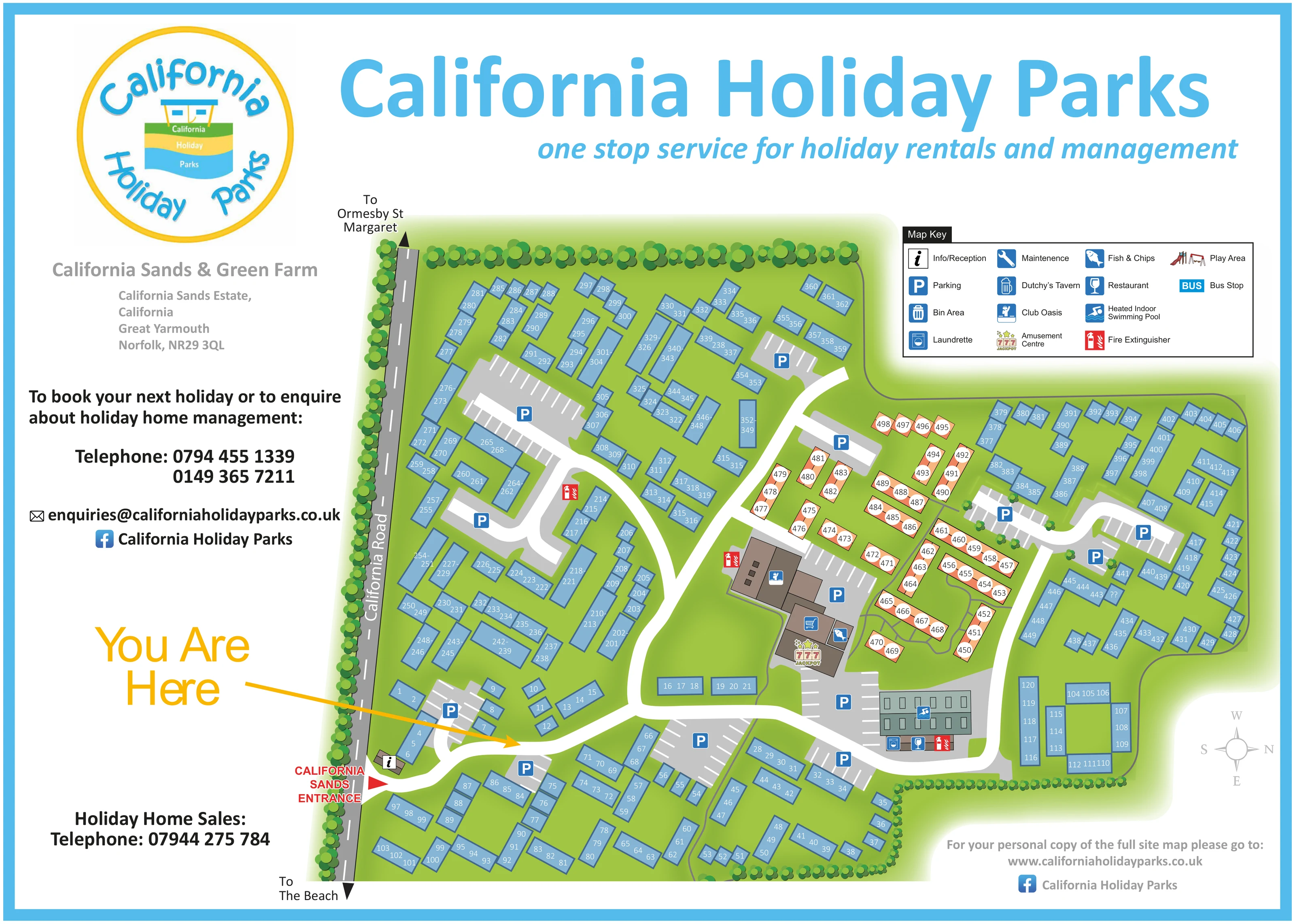
This map brings California Sands and Green Farm together in a single, branded site guide for California Holiday Parks in coastal Norfolk. The plan shows a substantial arrangement of numbered holiday accommodation, with parking courts, branching internal roads and a central group of leisure and service buildings. California Road anchors the left-hand edge, while arrows point towards Ormesby St Margaret and the beach outside the mapped grounds.
The design combines a practical overhead plan with a bold display layout. Blue accommodation blocks stand against lime-green grounds, a smaller peach-coloured group provides visual contrast, and repeated tree symbols describe the landscaped boundaries. A large yellow You Are Here arrow draws attention to the entrance-side route, supported by a reception marker and a red California Sands entrance label.
For visitors, the map connects accommodation numbers with recognisable destinations such as Club Oasis, the amusement centre, fish and chips and the indoor swimming pool. For the gallery, it illustrates how a large combined-site plan can accommodate extensive numbering, shared amenities and prominent commercial branding without relying on detailed architectural illustration.
The single landscape-format artwork is headed California Holiday Parks, with California Sands & Green Farm named beneath the circular logo. A left-hand information column balances the main plan, which extends across the centre and right of the page. The accompanying enlargement is a closer view of the same artwork, not an additional site or map variant.
California Road runs along the western edge of the drawing. The California Sands entrance is marked near the lower-left corner, beside a small information and reception building. From here, a broad white road crosses the lower accommodation area and branches towards the upper and eastern sections. Grey parking courts, identified by blue P symbols and white bay lines, are distributed throughout rather than concentrated in one car park.
Most accommodation appears as blue rectangular blocks containing one or several white unit numbers. Their varied angles and lengths describe groups arranged around access roads and parking courts. A peach-coloured cluster with circular white number labels occupies the area above and to the right of the main facilities. The colour distinction is visible, but the key does not define it as a particular accommodation type.
Brown amenity buildings carry the Club Oasis, fish-and-chips and amusement-centre markers, including a conspicuous 777 jackpot illustration. A separate grey-green building group carries the swimming-pool marker, with laundrette and restaurant symbols along its lower edge. A shopping-trolley icon also appears within the central cluster. Red fire-point markers provide a contrasting layer of practical information.
The upper-right key explains the pictograms and includes further entries such as Dutchy’s Tavern, maintenance, a play area and a bus stop. Tree-lined boundaries, thin connecting paths, a right-pointing north compass and an off-site beach direction complete the guide.
KEEP EXPLORING
Chosen for shared landscapes, accommodation or facilities.
 Explore the map ↗
United Kingdom
Coastal park map with static-caravan rows, touring pitches, a camping field and two leisure clusters.
 Explore the map ↗
United Kingdom
A colour-zoned coastal park map with touring areas, woodland trails, ponds and a leisure club.
 Explore the map ↗
United Kingdom
Colour-coded accommodation, central leisure facilities and coastal paths on an illustrated headland park map.
Features may come from the sample artwork, its key or published park information. Approximate numbers describe the drawing and may cover only part of a park. They are intended to help you compare map examples. Current facilities and booking information should be checked with the park.
LET’S MAP YOUR PARK
For a map quotation, find your park and draw a rough boundary around it. The area you select helps us work out the design time and price.
Draw your park for a quote ↗Or talk to our map designers
01751 473136