
Horseshoe Lake
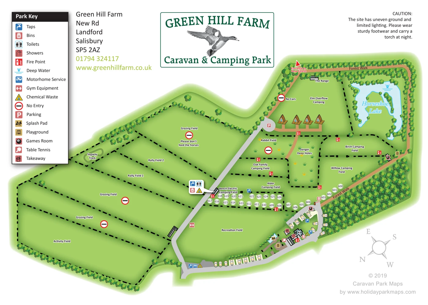
A pale blue, irregular horseshoe-shaped lake with cyan banks and internal green landforms forms the principal landscape landmark. A deep-water symbol is present; fishing and swimming are not identified.
ILLUSTRATED PARK MAP · P479
New Rd, Landford, Salisbury · United Kingdom
 Enlarge the map ↗
A SENSE OF THE PLACE
Green Hill Farm Holiday Village is based at New Rd, Landford, Salisbury. The park has direct access to the New Forest National Park. Current accommodation includes two- to four-bedroom lodges, holiday homes, safari tents and adults-only shepherd's huts.
Seasonal ranger activities include archery, cycling, den-making and other outdoor sessions. A splash pad, children's play area, park shop and Wi-Fi are listed. Seasonal Ember Pizzeria serves wood-fired food.
LOOK CLOSER
A pale blue, irregular horseshoe-shaped lake with cyan banks and internal green landforms forms the principal landscape landmark. A deep-water symbol is present; fishing and swimming are not identified.
Repeated multi-circle tree symbols line the site edge, walking route and lake banks, with a particularly dense illustrated belt along the lower-right perimeter. These are stylised landscape depictions, not measured woodland coverage.
Open grazing compartments are explicitly labelled, with no-entry signs and a horse-related notice in the upper field.
A tufted, irregular green area is labelled Rabbit Field and accompanied by no-entry and deep-holes warnings. The illustration does not establish habitat extent or wildlife numbers.
The New Forest is identified as a destination beyond the marked entrance. The artwork does not draw or measure the national park boundary.
Water-tap symbols identify several service locations, including the entrance-side servicing apron, the lower-right touring area, the numbered camping strip and the callout beside Beech.
Bin locations are marked beside service buildings and near the barrier at the lower end of Forest Walk.
Toilets are located by a service-building callout beside Beech and at the main lower-right amenity block. No separate accessible-toilet designation is visible.
Water-tap symbols identify several service locations, including the entrance-side servicing apron, the lower-right touring area, the numbered camping strip and the callout beside Beech.
Bin locations are marked beside service buildings and near the barrier at the lower end of Forest Walk.
Toilets are located by a service-building callout beside Beech and at the main lower-right amenity block. No separate accessible-toilet designation is visible.
A shower symbol marks the main amenity building.
Fire-point symbols are distributed around camping-field boundaries, the pod-like structures and the main amenities. These are historical mapped positions, not verified current emergency information.
The lake carries a deep-water warning. This does not identify a swimming or fishing facility.
A motorhome servicing point is shown on a grey apron beside taps and chemical waste. It is not an accommodation pitch.
Gym equipment is indicated on the edge of the Recreation Field; the illustration does not specify individual apparatus.
Chemical-waste disposal is indicated at the entrance-side service apron, the main amenities and the service-building callout beside Beech.
No-entry symbols mark grazing areas and Rabbit Field. Another is accompanied by 'No Cars' on the route beyond the parking area.
A parking symbol marks a rounded grey area where the main internal road ends beside the pod-like structures. No bay count is supplied.
A splash pad is explicitly identified beside the main recreation and amenity area. The blue shape should not be reclassified as a swimming pool.
Playground symbols identify a play area beside the splash pad and another beside Forest Walk at the Birch/Willow boundary.
Games-room symbols are placed on buildings beside Forest Walk and at the top of the lower-right touring loop.
Table tennis is marked beside the principal amenity buildings and play area.
A takeaway symbol identifies a small building beside the main amenities. No business name, menu or operating period is shown.
The field name explicitly indicates electric camping. Individual hook-up pedestals and their allocation are not drawn.
A small looped track is explicitly labelled for Segway use. Hire arrangements and current availability are not stated.
A narrow building is labelled 'The Range'. The activity practised there is not specified by the artwork.
An open field is designated for activities without individual sports or equipment being specified.
A large open recreation field lies between the central road, camping strip and lower touring pitches.
A tan route labelled Forest Walk follows the upper and right edges of the site and connects with the marked New Forest entrance.
A red-and-white barrier illustration marks the junction between the lower-right road and Forest Walk. No access credentials are shown or required for this analysis.
The artwork includes a site-wide caution about uneven ground and limited lighting, and a local deep-holes warning. These are recorded as historical map content rather than current visitor instructions.
A park shop is listed in the supplied operator research but is not identified on this map.
Wi-Fi is listed in the supplied operator research. Coverage, access arrangements and current availability are not established by the artwork.
The supplied research names a seasonal pizzeria serving wood-fired food. It cannot be confidently equated with the unnamed takeaway on the historical map.
Dog washing stations and feeding bowls are listed in supplied research, alongside a statement that dogs are welcome. None is depicted on this artwork, and current policies require checking.
Supplied research lists seasonal ranger-led outdoor activities, including archery, cycling and den-making. The historical map does not establish their individual locations or programme.
A pale blue, irregular horseshoe-shaped lake with cyan banks and internal green landforms forms the principal landscape landmark. A deep-water symbol is present; fishing and swimming are not identified.
Repeated multi-circle tree symbols line the site edge, walking route and lake banks, with a particularly dense illustrated belt along the lower-right perimeter. These are stylised landscape depictions, not measured woodland coverage.
Open grazing compartments are explicitly labelled, with no-entry signs and a horse-related notice in the upper field.
A tufted, irregular green area is labelled Rabbit Field and accompanied by no-entry and deep-holes warnings. The illustration does not establish habitat extent or wildlife numbers.
The New Forest is identified as a destination beyond the marked entrance. The artwork does not draw or measure the national park boundary.
READING THE MAP
This Green Hill Farm sample shows a caravan and camping layout at Landford on the edge of the New Forest. Named fields, touring areas, camping spaces and rally fields are arranged around an extensive rural site, with Horseshoe Lake and grazing areas helping to give the plan its character.
The illustration combines individual pitch markers with larger camping areas. A perimeter Forest Walk and a marked New Forest entrance help connect the internal plan with the surrounding setting. The artwork also brings together practical touring services and leisure features, including washrooms, a motorhome service point, takeaway, games rooms, play areas and a splash pad.
As an example of park-map design, this is especially relevant to spacious campsites with several fields, overflow areas and outdoor activities. It shows how naming and colour can make a dispersed layout easier to understand. The sample presents the caravan-and-camping version of the park, whose later holiday-village development forms a separate chapter in the site’s story.
This single-page map presents Green Hill Farm Caravan & Camping Park as an irregular, field-based site, with a broad rural section on the left and a more closely arranged camping, lake and amenity area on the right. The plan is predominantly overhead, but decked pod-like structures introduce small oblique illustrations. Bright grass greens, darker edge shading and repeated circular tree canopies give the artwork a soft, landscaped appearance against a white background.
A grey access road enters from the lower edge, passes the Recreation Field and continues diagonally towards a rounded parking area. A second branch follows the lower touring pitches and curves around the main amenity buildings. Tan paths distinguish the Forest Walk, which follows the upper and right perimeter, passes Horseshoe Lake and connects with a clearly marked entrance to the New Forest. A no-cars annotation and a striped barrier add vehicle-control information without depicting a full traffic-management system.
Heavy black dashed lines divide the grazing, rally and camping fields. Oak, Alder, Beech, Birch, Willow and Elm have bold black labels with white outlines. Numbered caravan-shaped symbols line the lower road and amenity loop, while white circular number badges mark a separate camping strip. Other camping and rally fields remain unnumbered. Horseshoe Lake is drawn in pale blue with a cyan outline and a large italic label; grass tufts distinguish the Rabbit Field hazard area.
A large boxed Park Key occupies the upper-left corner, explaining water, waste, sanitary, safety and recreation symbols. These locate facilities including motorhome servicing, showers, games rooms, play areas, a splash pad and a takeaway. A white callout groups services beside Beech. The upper portion also contains the park contact block, a green-framed bird logo and a caution notice. A rotated compass and pale grey designer attribution complete the lower-right margin. The visible copyright is 2019, but the artwork supplies no survey date, scale bar or accommodation total.
KEEP EXPLORING
Chosen for shared landscapes, accommodation or facilities.
 Explore the map ↗
United Kingdom
Colour-coded accommodation, lakeside facilities and woodland routes at Burton Constable Holiday Park & Arboretum.
 Explore the map ↗
United Kingdom
Woodland park map with mixed pitches, bell tents, lodges and a fishing lake.
 Explore the map ↗
United Kingdom
Woodland holiday homes, named camping fields and farm buildings on a colour-coded Nether Wasdale park map.
Features may come from the sample artwork, its key or published park information. Approximate numbers describe the drawing and may cover only part of a park. They are intended to help you compare map examples. Current facilities and booking information should be checked with the park.
TAKE A CLOSER LOOK
View the illustrated map in detail or choose a file to download. These are sample maps; contact the park for current visitor information.


LET’S MAP YOUR PARK
For a map quotation, find your park and draw a rough boundary around it. The area you select helps us work out the design time and price.
Draw your park for a quote ↗Or talk to our map designers
01751 473136
 ingpage_Page_1.png
 ingpage_Page_2.png