
Green spaces and planted boundaries
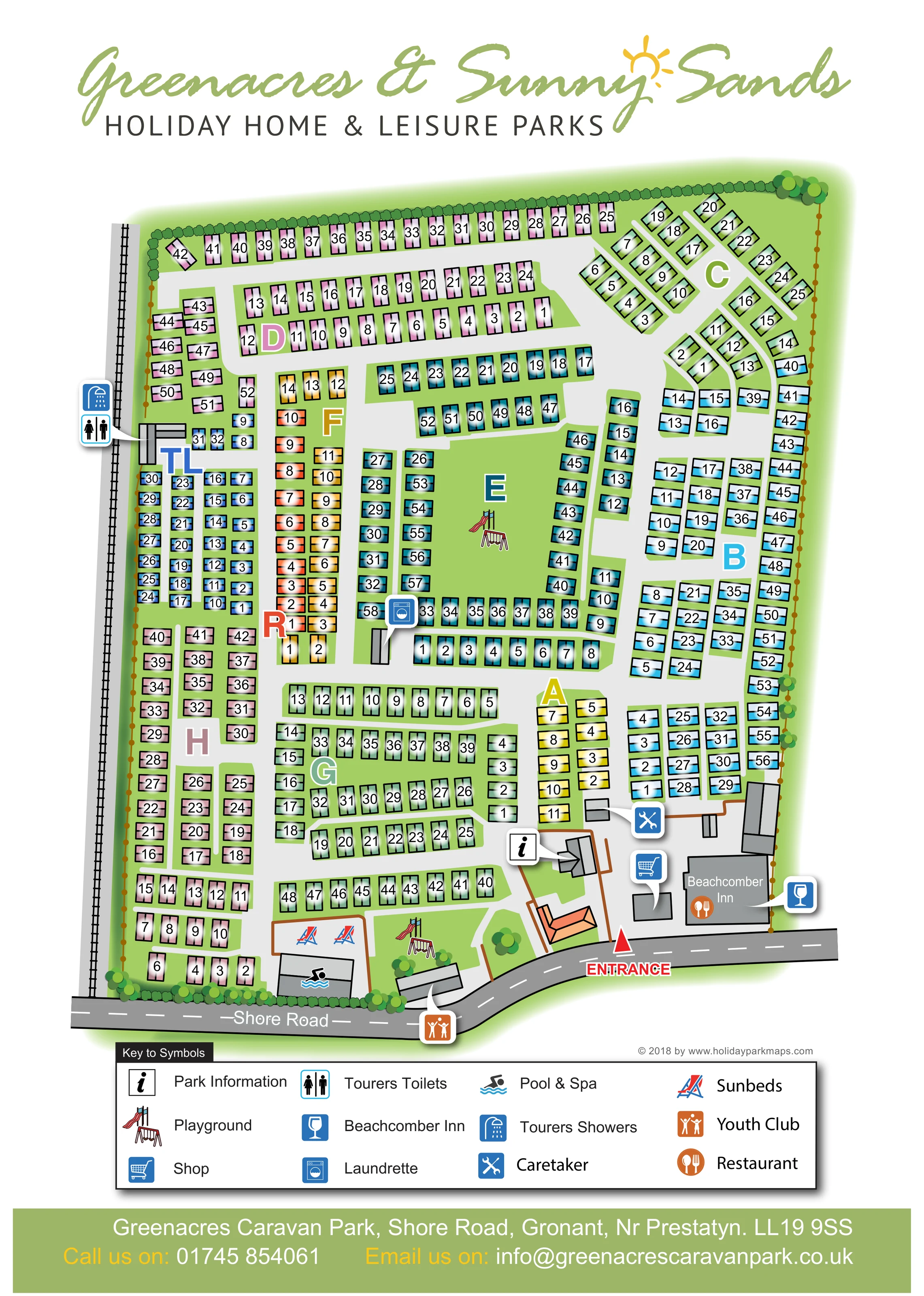
Green ground surrounds the accommodation, with a larger central play lawn, clipped hedge-like boundary planting, scattered rounded trees and brown perimeter fence lines.
ILLUSTRATED PARK MAP · P480
Greenacres Caravan Park, Shore Road, Gronant, Nr Prestatyn · United Kingdom
 Enlarge the map ↗
A SENSE OF THE PLACE
Greenacres and Sunny Sands provide caravan holidays and ownership near Gronant Beach in North Wales. The parks offer privately owned static caravans, rental caravans and touring provision.
The beach and nearby Prestatyn give visitors options for coastal outings. A swimming pool and health suite form part of the combined parks' facilities, while the map shows the layout associated with the Greenacres site.
LOOK CLOSER
Green ground surrounds the accommodation, with a larger central play lawn, clipped hedge-like boundary planting, scattered rounded trees and brown perimeter fence lines.
An information symbol points to a small building beside the main arrival area, immediately above the Shore Road entrance.
A swimmer symbol identifies the pool and spa building along the lower-left frontage.
Two deckchair-style symbols appear in an outlined area beside the pool and spa, matching the legend's Sunbeds entry.
Illustrated slide-and-swing equipment marks two play areas: one in the central green space within sector E and one near the pool and Shore Road frontage.
A blue shopping-trolley callout identifies a small building in the entrance-side service cluster.
Separate toilet and shower icons point to the washroom building beside the TL accommodation area on the left boundary.
A large grey building at the lower right is labelled Beachcomber Inn and carries a drinking-glass callout.
An information symbol points to a small building beside the main arrival area, immediately above the Shore Road entrance.
A swimmer symbol identifies the pool and spa building along the lower-left frontage.
Two deckchair-style symbols appear in an outlined area beside the pool and spa, matching the legend's Sunbeds entry.
Illustrated slide-and-swing equipment marks two play areas: one in the central green space within sector E and one near the pool and Shore Road frontage.
A blue shopping-trolley callout identifies a small building in the entrance-side service cluster.
Separate toilet and shower icons point to the washroom building beside the TL accommodation area on the left boundary.
A large grey building at the lower right is labelled Beachcomber Inn and carries a drinking-glass callout.
An orange cutlery symbol is placed on the Beachcomber Inn building, identifying the restaurant within that facility cluster.
A washing-machine callout points to a narrow building between the central accommodation rows and the TL side of the park.
A crossed-tools callout identifies a small building just inside the entrance-side facilities area.
An orange figures callout points to a building beside Shore Road, close to the lower playground and pool.
The named public road runs across the foot of the illustration, curving past the main entrance.
A red triangle and bold ENTRANCE label mark access from Shore Road beside the Beachcomber Inn and information building.
Broad pale-grey lanes form a connected network of straight aisles, branching junctions and short loops between the accommodation sectors.
An unlabelled rail-and-sleeper line runs along the left edge, providing a strong external orientation feature. No station or railway access is indicated.
Green ground surrounds the accommodation, with a larger central play lawn, clipped hedge-like boundary planting, scattered rounded trees and brown perimeter fence lines.
READING THE MAP
This illustrated map of Greenacres Caravan Park in Gronant, near Prestatyn, turns a large caravan layout into a clearly structured visitor guide. Set beneath the shared Greenacres & Sunny Sands branding, the plan uses pastel accommodation colours, bold sector letters and numbered caravan symbols to distinguish the park's many rows. Shore Road anchors the lower edge, while a railway along the left boundary gives the drawing another recognisable reference point.
The entrance is marked beside a concentrated group of facilities, including the Beachcomber Inn, restaurant, shop and park information point. Elsewhere, the map identifies a pool and spa, sunbeds, a youth club, a laundrette and touring washrooms. Two illustrated playgrounds bring more pictorial detail to the otherwise compact plan.
Rather than depicting the surrounding coastline, this sample focuses on finding accommodation and moving around the site. Its generous symbol key, prominent arrival marker and colour-coded sectors show how a dense holiday park can be presented within a single portrait-format visitor map.
The artwork presents Greenacres as a tall, enclosed site entered from Shore Road at the lower right. A darker road frontage and red entrance triangle establish the arrival point, with the information building, shop, caretaker location and Beachcomber Inn grouped nearby. The inn is labelled directly on its grey footprint, while drinking-glass and cutlery symbols identify its social and dining functions.
Inside the park, pale-grey roads divide the caravan accommodation into lettered sectors. Most units sit in straight, closely spaced rows, but the upper-right area introduces diagonal lanes and angled caravans. Pink, blue, green, yellow and orange fills distinguish different parts of the plan, reinforced by large outlined sector letters and individual black plot numbers. A smaller TL area lies against the left boundary beside the tourers' toilets and showers. The colour system is primarily a wayfinding device: the legend does not assign accommodation types to the sector colours.
A central green space contains a slide-and-swing illustration, with another playground near the lower frontage. The pool and spa building sits towards the lower left, accompanied by the legend's deckchair-style sunbed symbols. A nearby youth club is identified by an orange callout, and a washing-machine icon points to the laundrette further inside the park.
Boundary hedges, scattered rounded trees and fence lines frame the accommodation. The railway on the left is drawn with rails and sleepers, contrasting with the simpler internal roads. Below the plan, a twelve-entry key explains the facility graphics, followed by the green address-and-contact footer. The enlarged legend views show details from this same page rather than separate map variants.
KEEP EXPLORING
Chosen for shared landscapes, accommodation or facilities.
 Explore the map ↗
United Kingdom
Coastal park map with static-caravan rows, touring pitches, a camping field and two leisure clusters.
 Explore the map ↗
United Kingdom
A wooded Allerton park plan with colour-coded neighbourhoods, touring pitches and a central facilities hub.
 Explore the map ↗
United Kingdom
Ashby Park map with seven fishing lakes, colour-coded accommodation and illustrated wooded shorelines.
Features may come from the sample artwork, its key or published park information. Approximate numbers describe the drawing and may cover only part of a park. They are intended to help you compare map examples. Current facilities and booking information should be checked with the park.
TAKE A CLOSER LOOK
View the illustrated map in detail or choose a file to download. These are sample maps; contact the park for current visitor information.


LET’S MAP YOUR PARK
For a map quotation, find your park and draw a rough boundary around it. The area you select helps us work out the design time and price.
Draw your park for a quote ↗Or talk to our map designers
01751 473136