
Wildlife and dog walking area
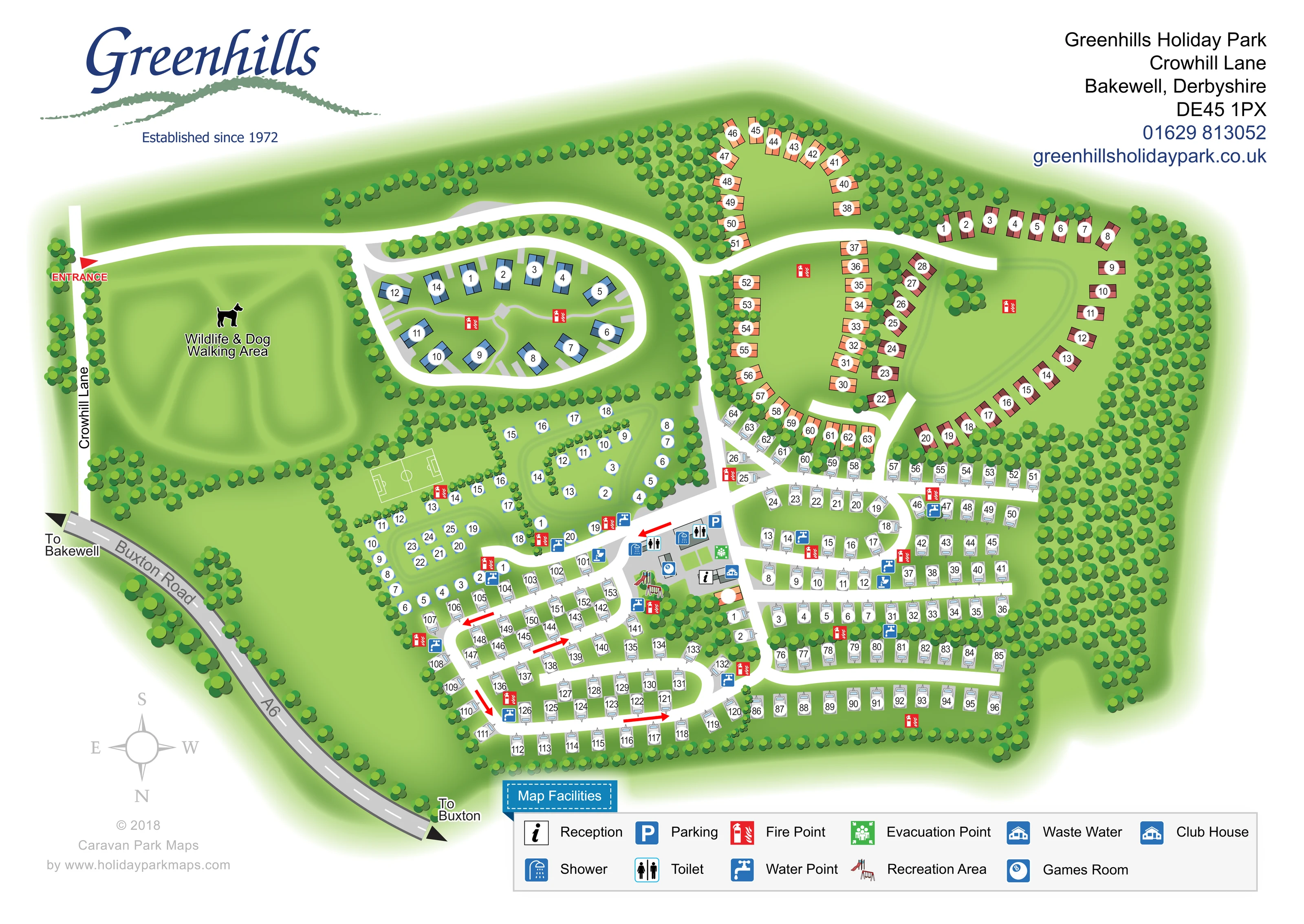
A large enclosed green area beside Crowhill Lane is explicitly labelled Wildlife & Dog Walking Area, with a dog silhouette and faint branching walking routes.
ILLUSTRATED PARK MAP · P483
Greenhills Holiday Park, Crowhill Lane, Bakewell, Derbyshire · United Kingdom
 Enlarge the map ↗
A SENSE OF THE PLACE
Greenhills Holiday Park is based at Crowhill Lane, Bakewell, Derbyshire. The 33-acre park lies near Bakewell on the lower Wye Valley slopes. Three fields are allocated to privately owned caravan holiday homes. The park provides capacity for 140 hardstanding touring units with 16-amp electricity and 45 tent pitches.
The Stable Bar operates at weekends with additional holiday opening periods.
LOOK CLOSER
A large enclosed green area beside Crowhill Lane is explicitly labelled Wildlife & Dog Walking Area, with a dog silhouette and faint branching walking routes.
Dense tree belts frame the park and divide its accommodation areas, with particularly broad planting along the right-hand edge.
An information symbol identifies reception in the central group of buildings at the junction between the camping and touring areas.
A blue P marks parking beside the central toilet and shower buildings.
Repeated toilet and shower symbols identify facilities on the grey central service area.
The house-shaped blue symbol used for Club House in the key appears beside the reception building.
A blue eight-ball symbol marks a separate small building within the central facilities cluster.
An illustrated slide and swings sit among trees beside the central buildings; the legend calls this the Recreation Area.
An information symbol identifies reception in the central group of buildings at the junction between the camping and touring areas.
A blue P marks parking beside the central toilet and shower buildings.
Repeated toilet and shower symbols identify facilities on the grey central service area.
The house-shaped blue symbol used for Club House in the key appears beside the reception building.
A blue eight-ball symbol marks a separate small building within the central facilities cluster.
An illustrated slide and swings sit among trees beside the central buildings; the legend calls this the Recreation Area.
White football-pitch markings occupy a grass enclosure between the wildlife walking area and the camping pitches.
Blue tap symbols are distributed through the camping and touring sections.
Blue disposal-style symbols appear beside touring lanes. The key also lists Waste Water, although its displayed pictogram differs from these mapped symbols.
Red extinguisher symbols are repeated across the accommodation groups and beside central recreation facilities.
A green assembly symbol marks an evacuation point within the central service area.
A large enclosed green area beside Crowhill Lane is explicitly labelled Wildlife & Dog Walking Area, with a dog silhouette and faint branching walking routes.
Dense tree belts frame the park and divide its accommodation areas, with particularly broad planting along the right-hand edge.
A red entrance arrow marks access from Crowhill Lane on the left side of the plan.
Broad white roads connect the entrance, holiday-home groups and touring lanes. Red arrows show directional circulation through parts of the touring area.
A grey external road follows the lower-left boundary, labelled Buxton Road and A6, with directions towards Bakewell and Buxton.
READING THE MAP
This illustrated map of Greenhills Holiday Park brings together caravan holiday homes, touring pitches and camping areas in a single tree-framed plan. Set on Crowhill Lane near Bakewell in Derbyshire, the park is shown beside Buxton Road and the A6, with clear directions towards Bakewell and Buxton. A prominent entrance arrow starts the visitor’s journey, while broad white roads lead through the accommodation areas to a central cluster of facilities.
The artwork gives considerable space to the park’s green surroundings. A large wildlife and dog walking area sits beside the entrance, with faint routes drawn through its grass enclosure. Tree belts separate the holiday-home groups, camping areas and touring rows, making the different parts of the site easy to recognise. A marked football field and illustrated playground add useful recreational landmarks.
Numbered pitch markers and a two-row facilities key provide the practical layer. Reception, showers, toilets, parking, the club house and games room are shown around the central buildings, while water and fire points are distributed across the site. The result is a useful sample of a mixed-accommodation park map where landscape, pitch finding and shared facilities all need to remain legible.
The single-page plan is arranged around a long approach road from Crowhill Lane, entering at the left and travelling across the upper part of the park. Below it, the large Wildlife & Dog Walking Area is enclosed by trees and contains softly drawn branching routes. Immediately to its right, blue caravan holiday-home symbols sit within an oval road loop. Peach and burgundy holiday-home groups occupy the upper-right grass enclosures, following curved boundaries and planted edges.
Camping is represented by numbered blue pitch markers in two adjoining green areas left of the central road. A small football field, drawn with white touchlines and goal-area markings, sits beside them. The touring accommodation uses a different visual language: pale caravan illustrations line parallel roads, perimeter lanes and the looping section towards the bottom left. White number discs keep pitch labels prominent against both the caravan roofs and grass.
The central grey service area contains reception, parking, toilet and shower symbols, a games room and the club-house marker. Illustrated slides and swings identify the recreation area beside these buildings. Blue water-point symbols and red fire-point symbols repeat throughout the accommodation sections, with disposal symbols beside touring roads and a green evacuation-point marker near the facilities.
Outside the park, the grey A6 curves diagonally along the lower-left edge, with labels towards Bakewell and Buxton. A pale compass indicates that north is towards the bottom of the page. The large Greenhills branding balances the address block above the plan, and the bottom facilities key explains the main symbols. The detail views enlarge this same artwork; they are not separate sections or additional accommodation plans.
KEEP EXPLORING
Chosen for shared landscapes, accommodation or facilities.
 Explore the map ↗
United Kingdom
Woodland-framed Barnsoul map with mixed accommodation, shared facilities and paw-marked walking routes.
 Explore the map ↗
United Kingdom
Riverside park map with named pitch fields, illustrated huts and a paw-print dog walk.
 Explore the map ↗
United Kingdom
Tree-lined touring areas, The Paddock holiday homes and recreation spaces on Golden Square's illustrated park map.
Features may come from the sample artwork, its key or published park information. Approximate numbers describe the drawing and may cover only part of a park. They are intended to help you compare map examples. Current facilities and booking information should be checked with the park.
TAKE A CLOSER LOOK
View the illustrated map in detail or choose a file to download. These are sample maps; contact the park for current visitor information.


LET’S MAP YOUR PARK
For a map quotation, find your park and draw a rough boundary around it. The area you select helps us work out the design time and price.
Draw your park for a quote ↗Or talk to our map designers
01751 473136