
River boundary
A winding blue river frames the northern and eastern edges, with textured banks and scattered stone details.
ILLUSTRATED PARK MAP · P044
Bryn Gloch, Betws Garmon, Caernarfon, Gwynedd · United Kingdom
 Enlarge the map ↗
A SENSE OF THE PLACE
Bryn Gloch Caravan and Camping Park is a base for exploring Eryri near Betws Garmon and Caernarfon. It offers touring and camping pitches, shepherd's huts, caravan rentals and a holiday house.
Heated bathrooms, a shop, Wi-Fi and washing facilities support stays, while playgrounds, a games room and a football field provide recreation. Dog walking and washing areas are also available. Grass, hardstanding and serviced pitch options allow visitors to choose the facilities they need.
LOOK CLOSER
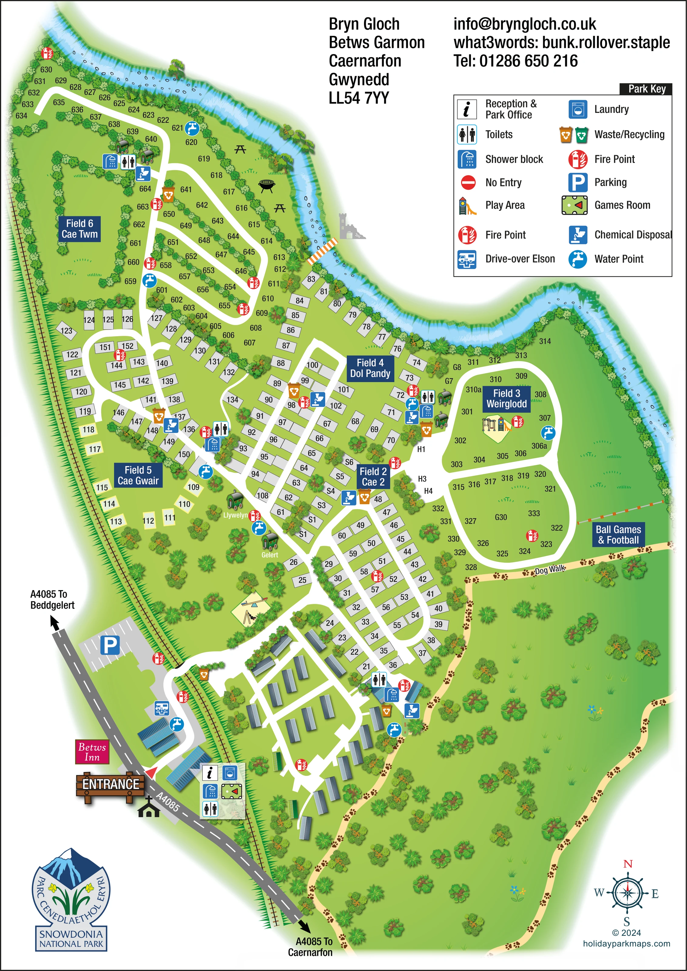
A winding blue river frames the northern and eastern edges, with textured banks and scattered stone details.
Dense tree and shrub borders separate fields, frame pitches and enclose the broad southern dog-walking green.
An information symbol identifies reception within the entrance-side building cluster.
Repeated toilet and shower symbols mark service clusters near the entrance, central pitches and northern riverside field.
A washing-machine symbol is placed at the main entrance-side facilities.
The snooker-table symbol marks a games room beside the entrance facilities.
Illustrated play equipment appears within Field 3 Weirglodd and in the lower central green near the caravan section.
A labelled recreation area lies on the eastern side of Field 3, beside the river and dog-walking route.
An information symbol identifies reception within the entrance-side building cluster.
Repeated toilet and shower symbols mark service clusters near the entrance, central pitches and northern riverside field.
A washing-machine symbol is placed at the main entrance-side facilities.
The snooker-table symbol marks a games room beside the entrance facilities.
Illustrated play equipment appears within Field 3 Weirglodd and in the lower central green near the caravan section.
A labelled recreation area lies on the eastern side of Field 3, beside the river and dog-walking route.
A pale tan route decorated with paw prints follows the lower and eastern green perimeter and runs beneath the football area.
A marked parking area sits beside the A4085, just above the main entrance.
Blue tap symbols are distributed around the entrance and accommodation fields.
Repeated disposal symbols occur within several service clusters across the park.
A drive-over disposal symbol is shown on the entrance approach, separate from the repeated chemical-disposal points.
Bin symbols mark collection points beside roads and service buildings.
Red circular fire-point symbols provide conspicuous markers throughout the accommodation areas.
Picnic-table illustrations appear on the grass beside the northern river bend.
A small freestanding barbecue is illustrated near the riverside picnic tables; no operational details are given.
A winding blue river frames the northern and eastern edges, with textured banks and scattered stone details.
A narrow orange-and-white crossing spans the river near the junction of Fields 6 and 4.
A continuous rail-and-sleeper line runs along the western side and is crossed by the entrance road. The railway is not named in the artwork.
The entrance is prominently marked beside the A4085, with external directions towards Beddgelert and Caernarfon.
A roadside label identifies Betws Inn beside the entrance area as a neighbouring landmark.
Dense tree and shrub borders separate fields, frame pitches and enclose the broad southern dog-walking green.
The key includes a no-entry symbol, but no definite placement is evident in the main plan.
READING THE MAP
This illustrated map of Bryn Gloch Caravan and Camping Park presents a large, varied holiday site at Betws Garmon, near Caernarfon in Eryri. A winding river frames the upper and right-hand edges, while a railway corridor and the A4085 define the approach on the opposite side. These distinctive boundaries give visitors useful landmarks before they begin looking for an individual pitch.
The map brings several accommodation patterns together: compact rows of touring pitches, more open numbered grass fields, a group of static caravans near the entrance and small shepherd's-hut illustrations, including Llywelyn and Gelert. Bold navy panels identify the named fields without obscuring their layout.
Facilities are explained through a prominent key and repeated symbols placed around the park. Toilets, showers, water and disposal points sit alongside leisure features such as play areas, a games room and the ball-games field. A paw-print dog-walking route extends through the greener perimeter. The result is a practical example of how a detailed touring and camping plan can retain the character of its riverside setting.
The portrait composition follows Bryn Gloch's elongated footprint, beginning with the entrance beside the A4085 at the lower left. A wooden entrance sign, the Betws Inn label and road arrows towards Beddgelert and Caernarfon establish the arrival context. Reception, laundry, toilets, showers and the games room are grouped around the entrance buildings, with parking and a drive-over Elson point nearby. The internal road crosses the illustrated railway and then branches into the accommodation areas.
Long, shaded caravan roofs distinguish the entrance-side static section from the pale rectangular pitches farther into the park. Central pitch rows follow straight and curved lanes through Field 2 Cae 2 and Field 4 Dol Pandy, while Field 5 Cae Gwair spreads towards the railway boundary. In the northern Field 6 Cae Twm and eastern Field 3 Weirglodd, numbered grass positions follow broader road loops. Green shepherd's-hut illustrations provide smaller landmarks, including the named Llywelyn and Gelert units.
The river is a major visual organising feature, curving past the upper fields and around the eastern edge. Trees and hedges reinforce field divisions, and a small crossing links the park edge with the opposite bank. Picnic tables and a barbecue illustration add detail beside the northern river bend. Play equipment appears in two parts of the park, while the labelled ball-games and football area occupies the eastern green. Below it, the tan dog walk continues around a broad planted perimeter, identified by repeated paw prints.
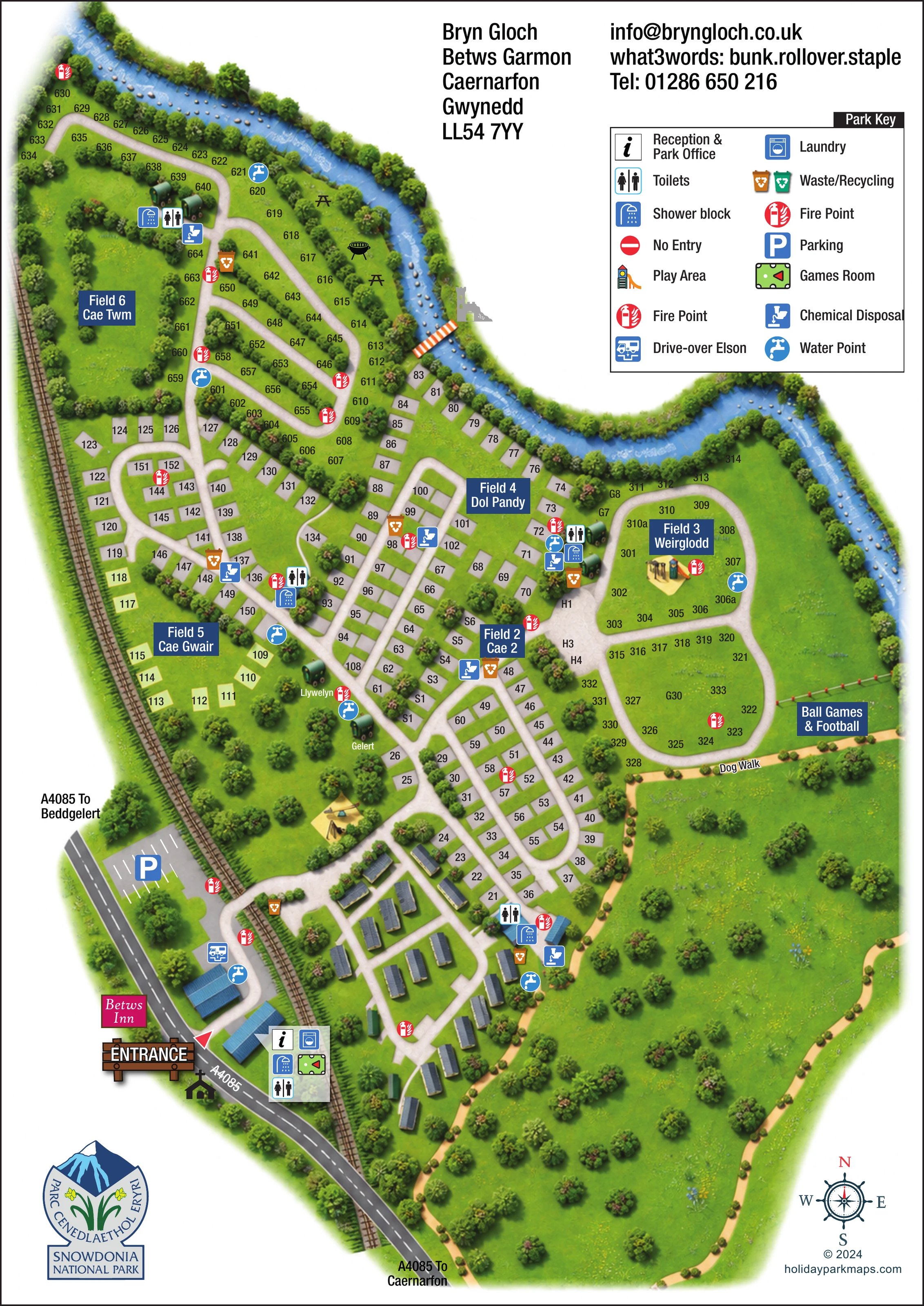
A large two-column key explains service and leisure symbols. Navy field panels, black pitch labels and a lower-right compass support navigation at different scales. The accompanying enlarged detail shows the same key and eastern field more clearly; it is not a separate map or additional accommodation area.
 Enlarge this map ↗
KEEP EXPLORING
Chosen for shared landscapes, accommodation or facilities.
 Explore the map ↗
United Kingdom
A woodland estate park map combining caravan loops, touring pitches, riverside paths and Bruce’s Cave landmarks.
 Explore the map ↗
United Kingdom
Woodland holiday homes, named camping fields and farm buildings on a colour-coded Nether Wasdale park map.
 Explore the map ↗
United Kingdom
Illustrated caravan park plan with woodland and riverside walks, fishing pools and wildlife panels.
Features may come from the sample artwork, its key or published park information. Approximate numbers describe the drawing and may cover only part of a park. They are intended to help you compare map examples. Current facilities and booking information should be checked with the park.
LET’S MAP YOUR PARK
For a map quotation, find your park and draw a rough boundary around it. The area you select helps us work out the design time and price.
Draw your park for a quote ↗Or talk to our map designers
01751 473136