
Catch & Release Pond
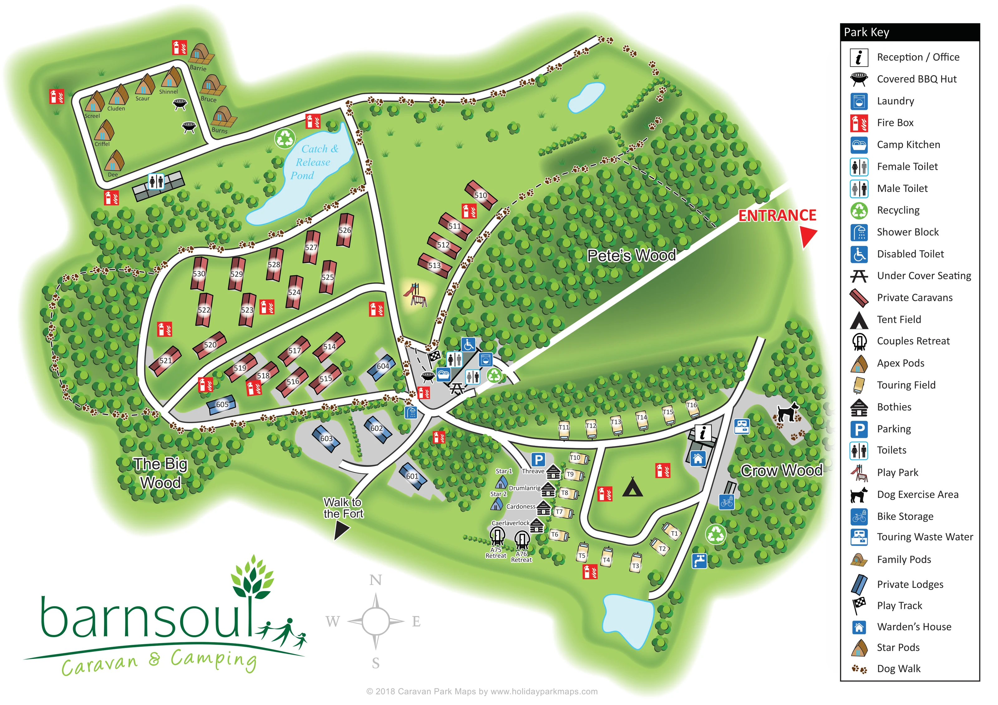
A large irregular blue pond is labelled Catch & Release Pond, between the north-western pods and the private caravan area.
ILLUSTRATED PARK MAP · P402
Shawhead, Dumfries · United Kingdom
 Enlarge the map ↗
A SENSE OF THE PLACE
Barnsoul is a lodge resort at Shawhead near Dumfries. Woodland trails, viewpoints and the surrounding Dumfries and Galloway countryside give it an outdoor focus.
Accommodation includes Wi-Fi and parking arrangements that vary by property. Selected lodges welcome pets, and reception provides local advice and board games to borrow. The map records the site layout and can be used alongside the resort's current accommodation information.
LOOK CLOSER
A large irregular blue pond is labelled Catch & Release Pond, between the north-western pods and the private caravan area.
Two smaller unlabelled blue water bodies are illustrated in the northern grassland and at the southern end of the touring area.
Three named wooded areas organise the landscape: Pete’s Wood dominates the eastern side, The Big Wood lies south-west, and Crow Wood borders the eastern touring road.
An information symbol identifies reception beside the eastern arrival road, close to the touring area.
A blue house symbol marks a building beside reception.
The central amenity cluster includes male and female toilets, showers and a toilet marked with a wheelchair symbol. Another toilet building is shown near the north-western pods, with an additional shower marker by the southern lodges.
A washing-machine symbol places the laundry in the central amenity cluster.
The camp kitchen is marked beside the central shared facilities.
An information symbol identifies reception beside the eastern arrival road, close to the touring area.
A blue house symbol marks a building beside reception.
The central amenity cluster includes male and female toilets, showers and a toilet marked with a wheelchair symbol. Another toilet building is shown near the north-western pods, with an additional shower marker by the southern lodges.
A washing-machine symbol places the laundry in the central amenity cluster.
The camp kitchen is marked beside the central shared facilities.
Barbecue symbols appear within the north-western pod area and at the central amenity hub.
A picnic-table symbol identifies under-cover seating at the central facilities.
Green recycling symbols appear beside the catch-and-release pond, at the central hub and near Crow Wood.
Repeated red fire-box symbols are distributed through the accommodation areas and beside shared facilities.
A blue parking symbol marks a space beside the southern pods and bothies.
A disposal symbol is placed on the eastern road near reception and the touring positions.
A blue tap symbol appears near the southern end of the eastern road, although it has no separate entry in the park key.
A bicycle symbol identifies storage beside the eastern road near Crow Wood.
A small illustrated slide and swing stand on the grass between the private caravans and the central facilities.
A chequered-flag marker identifies the play track immediately north of the central amenity cluster.
A dog silhouette marks an exercise area within Crow Wood on the eastern side.
Brown paw-print markers trace a substantial route around the western accommodation, past the pond and across the northern landscape and woodland margins.
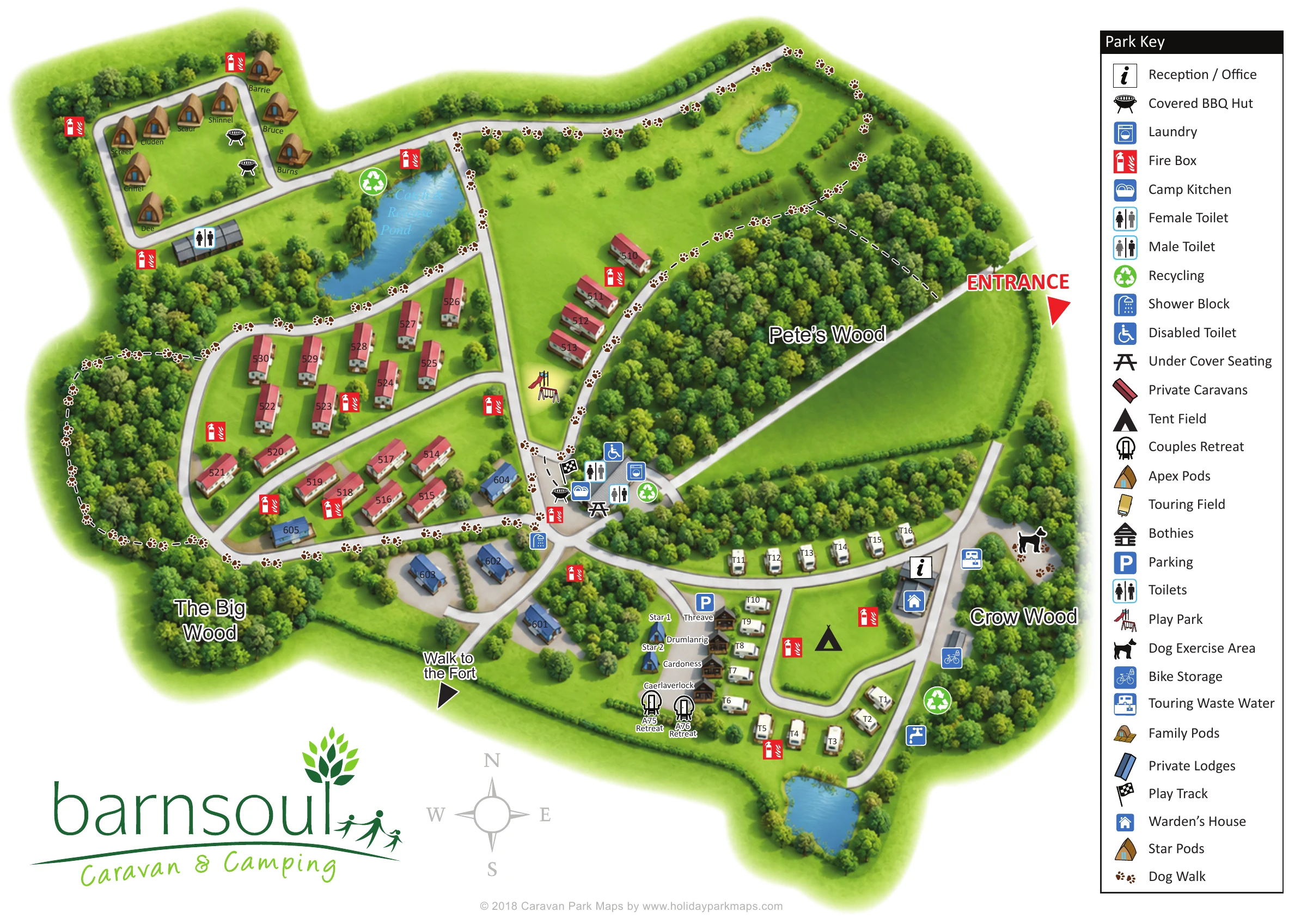
A large irregular blue pond is labelled Catch & Release Pond, between the north-western pods and the private caravan area.
Two smaller unlabelled blue water bodies are illustrated in the northern grassland and at the southern end of the touring area.
Three named wooded areas organise the landscape: Pete’s Wood dominates the eastern side, The Big Wood lies south-west, and Crow Wood borders the eastern touring road.
A large red entrance label and arrow mark arrival at the upper-right edge, beside the diagonal approach through Pete’s Wood.
White, dark-edged roads connect the central junction to western caravan loops, a north-western pod spur and the south-eastern touring and camping loop.
Dashed paths pass through wooded areas and connect with the paw-marked walking route.
A labelled arrow points out of the southern side of the plan towards a fort; the destination itself is not illustrated.
READING THE MAP
This illustrated map of Barnsoul Caravan Park at Shawhead, near Dumfries, brings a varied caravan, camping and glamping layout together within a strongly wooded setting. Pete’s Wood, The Big Wood and Crow Wood are prominent landmarks, while a labelled catch-and-release pond gives the north-western part of the plan another clear point of reference. White roads connect the accommodation areas, and brown paw prints make the dog-walking route immediately recognisable.
The artwork distinguishes private caravans, private lodges, touring positions and an open tent field, alongside several styles of pod, bothy and couples retreat. Rather than treating these as interchangeable plots, it gives each accommodation family its own colour or pictorial form. A tall park key explains the symbols for shared facilities, including the camp kitchen, laundry, toilets, showers and covered barbecue huts.
Large Barnsoul Caravan & Camping branding anchors the lower-left corner. The result is a useful sample for parks that need one visitor-facing map to explain different accommodation types, dispersed amenities and outdoor routes without losing the character of their landscape.
The plan is organised around a central road junction and shared amenity area. A conspicuous red entrance arrow marks arrival on the eastern edge beside Pete’s Wood, with a diagonal approach leading towards the middle of the park. Reception and the warden’s house are shown on the eastern road near the touring area. To the west, looping roads serve pink private caravans; blue private lodges occupy smaller spaces south of the junction.
A separate north-western enclosure contains named apex and family pods, with barbecue symbols and a nearby toilet building. Below this group, the irregular Catch & Release Pond sits beside trees and the paw-marked dog walk. In the south-east, cream touring-caravan symbols follow the road around an open tent field. Nearby, star pods, named bothies and couples retreats form a compact group beside parking and woodland.
The central facilities are communicated through a concentrated cluster of symbols: toilets, showers, an accessible-toilet marker, laundry, a camp kitchen, covered barbecue provision and under-cover seating. A play park is illustrated on the adjoining grass, and a chequered flag identifies the play track. Recycling and fire-box markers recur across the plan. Bike storage, touring waste-water disposal and a tap are shown along the eastern side.
Landscape and routes receive equal attention. Dense tree canopies define the three named woods, dashed paths cross the trees, and paw prints trace walking connections around accommodation and pond edges. A southern arrow points towards the fort without depicting the destination. Two further ponds add visual landmarks. The single artwork is accompanied by an overlapping enlargement of the key and eastern woodland; this is a detail view of the same design, not another site section.
 Enlarge this map ↗
KEEP EXPLORING
Chosen for shared landscapes, accommodation or facilities.
 Explore the map ↗
United Kingdom
A woodland estate park map combining caravan loops, touring pitches, riverside paths and Bruce’s Cave landmarks.
 Explore the map ↗
United Kingdom
A colour-zoned coastal park map with touring areas, woodland trails, ponds and a leisure club.
 Explore the map ↗
United Kingdom
Woodland holiday-park map with named accommodation areas, touring loops and illustrated recreation facilities.
Features may come from the sample artwork, its key or published park information. Approximate numbers describe the drawing and may cover only part of a park. They are intended to help you compare map examples. Current facilities and booking information should be checked with the park.
LET’S MAP YOUR PARK
For a map quotation, find your park and draw a rough boundary around it. The area you select helps us work out the design time and price.
Draw your park for a quote ↗Or talk to our map designers
01751 473136