
Fishing lakes
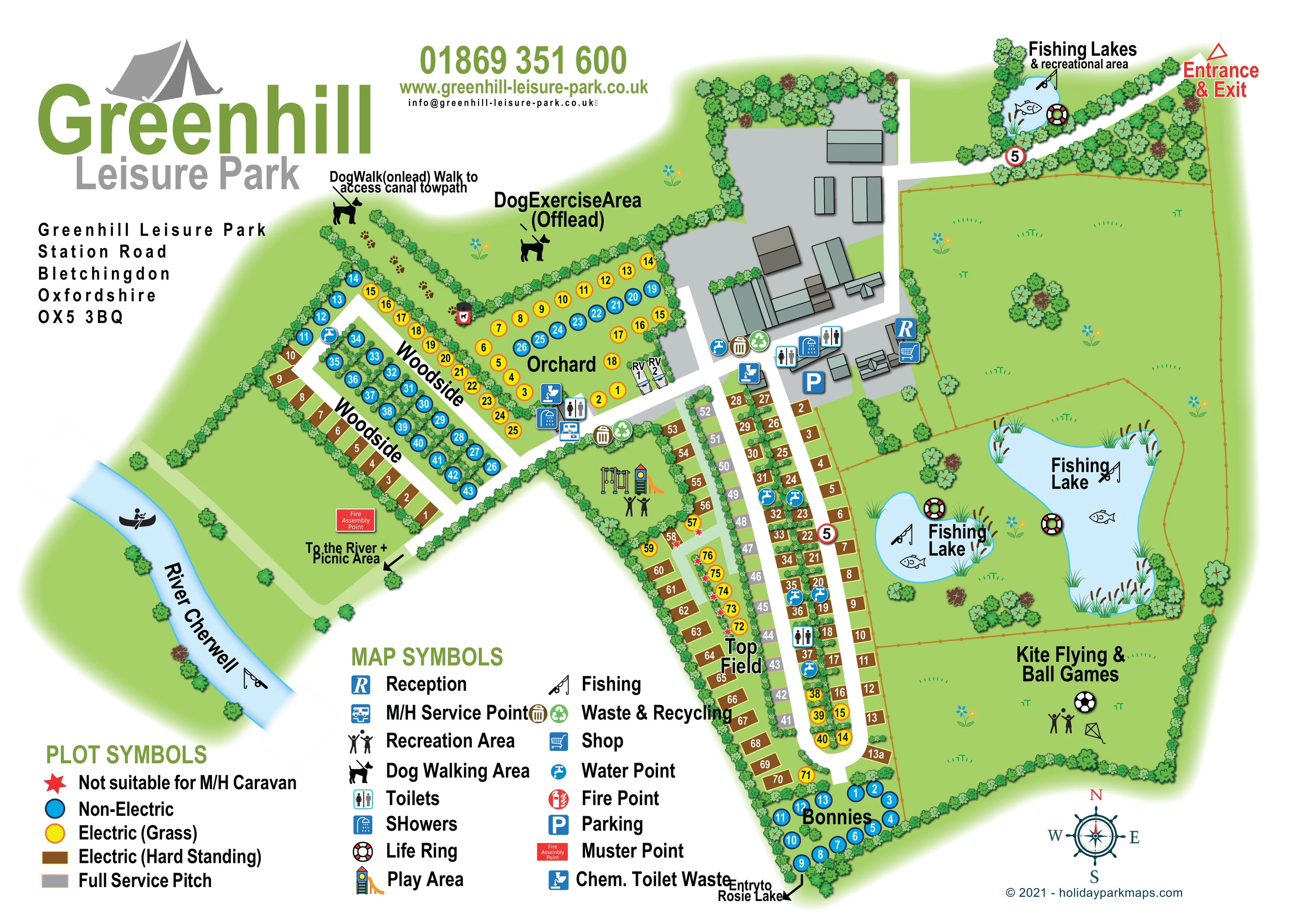
Three illustrated fishing waters are shown: a small lake beside the entrance approach and two larger lakes east of Top Field. Rods, fish and reeds reinforce their use and setting.
ILLUSTRATED PARK MAP · P482
Greenhill Leisure Park, Station Road, Bletchingdon, Oxfordshire · United Kingdom
 Enlarge the map ↗
A SENSE OF THE PLACE
Greenhill Leisure Park provides camping in countryside near Bletchingdon in Oxfordshire. The surrounding land offers opportunities for walking and watching wildlife, including deer and birds of prey.
A secure dog exercise field is a distinctive facility for visitors travelling with dogs. The map helps guests locate the camping areas and shared spaces within this rural park.
LOOK CLOSER
Three illustrated fishing waters are shown: a small lake beside the entrance approach and two larger lakes east of Top Field. Rods, fish and reeds reinforce their use and setting.
The named River Cherwell runs diagonally along the lower-left edge, with canoe and fishing illustrations.
Dense illustrated hedges and tree belts frame the entrance, separate camping areas and divide many individual pitches. Thin brown boundary lines enclose the eastern recreational grounds.
A blue reception symbol marks the building cluster beside the main internal road, between the entrance approach and Top Field.
The shop symbol is positioned beside reception in the central arrival and facilities cluster.
A blue parking symbol identifies a grey surfaced area immediately below the main buildings.
Toilet and shower symbols are grouped at the main buildings and beside Orchard; another toilet symbol appears within Top Field.
A motorhome service symbol appears at the shared facilities beside Orchard and the junction with Woodside.
A blue reception symbol marks the building cluster beside the main internal road, between the entrance approach and Top Field.
The shop symbol is positioned beside reception in the central arrival and facilities cluster.
A blue parking symbol identifies a grey surfaced area immediately below the main buildings.
Toilet and shower symbols are grouped at the main buildings and beside Orchard; another toilet symbol appears within Top Field.
A motorhome service symbol appears at the shared facilities beside Orchard and the junction with Woodside.
Chemical toilet disposal symbols are shown beside Orchard and near the central facilities.
Repeated blue tap symbols identify water points in Woodside, around the central buildings and along the Top Field pitch rows.
Paired bin and recycling symbols mark shared disposal locations beside the main buildings and Orchard.
A swing frame, climbing tower and slide illustrate a play area in the green space between Orchard and Top Field, accompanied by a recreation symbol.
Three illustrated fishing waters are shown: a small lake beside the entrance approach and two larger lakes east of Top Field. Rods, fish and reeds reinforce their use and setting.
Life-ring symbols are placed beside each of the three depicted fishing lakes.
A large open green area south of the fishing lakes is explicitly labelled for kite flying and ball games, with kite, football and recreation illustrations.
A broad green area above Orchard is labelled as an off-lead dog exercise area and marked with a dog silhouette.
A hedge-lined corridor above Woodside is labelled as an on-lead dog walk leading towards access to the canal towpath. Paw prints illustrate the route.
The named River Cherwell runs diagonally along the lower-left edge, with canoe and fishing illustrations.
An arrow below Woodside points onto a pale green route towards the river and picnic area.
A directional arrow at the southern end of Bonnies marks entry towards Rosie Lake, which is not itself drawn in that location.
Large red lettering and an outlined triangular marker identify the entrance and exit at the upper-right end of a tree-lined approach.
A red Fire Assembly Point sign is shown in the open green space between Woodside and the river route.
A fire point icon is included in the map-symbol legend; a corresponding location is not clearly identifiable on the plan.
Dense illustrated hedges and tree belts frame the entrance, separate camping areas and divide many individual pitches. Thin brown boundary lines enclose the eastern recreational grounds.
READING THE MAP
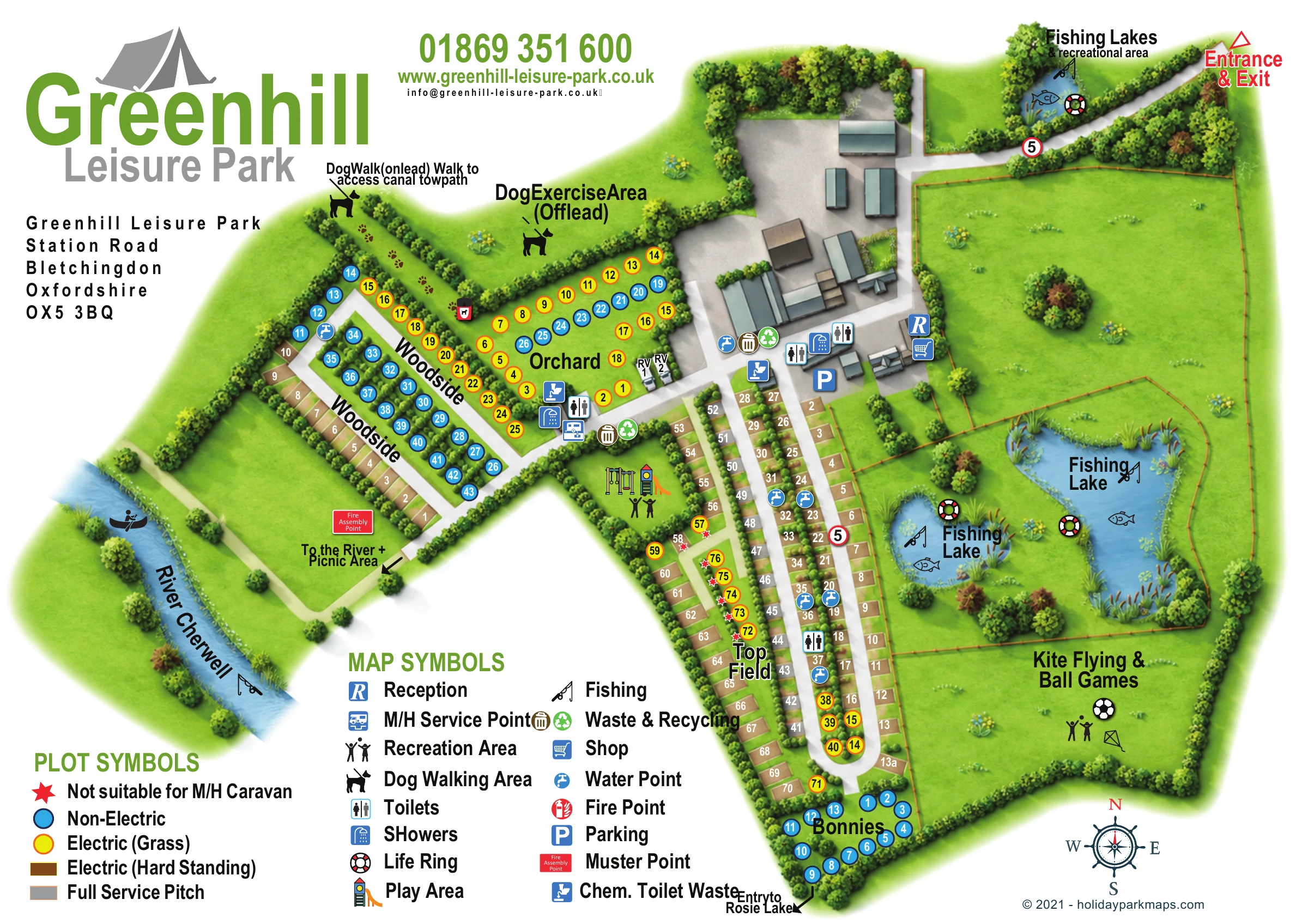
This illustrated map of Greenhill Leisure Park brings together camping and touring pitches, fishing lakes and outdoor recreation in a rural Oxfordshire setting. Located on Station Road in Bletchingdon, the park is presented as a collection of distinct areas rather than a single uniform campsite. Woodside and Orchard sit beside the central facilities, Top Field extends along a long touring loop, and Bonnies occupies a smaller pocket at the southern end.
The design makes pitch provision easy to distinguish through coloured circles and rectangular blocks, with separate symbols for non-electric, electric grass, hardstanding and full-service pitches. White access roads stand out against green grounds, while illustrated hedges give structure to both the larger areas and individual pitch rows.
Beyond the accommodation, the map gives substantial space to the park’s outdoor character. Fishing lakes, an off-lead dog exercise area, a dog walk towards the canal towpath and a field for kite flying and ball games all become useful visual landmarks. The River Cherwell and a route towards the riverside picnic area complete a plan that helps guests understand both their pitch location and the surrounding shared spaces.
The map is organised around a clear arrival sequence. A red Entrance & Exit label at the upper right leads into a tree-lined white road, passing a small fishing lake before reaching the main building cluster. Reception, the shop, parking, toilets and showers are marked here with blue pictograms. Water, chemical toilet disposal, waste and recycling symbols identify practical shared services without requiring lengthy labels beside every building.
From this central junction, the accommodation separates into recognisable neighbourhoods. Woodside has an angular road loop enclosed by illustrated hedges, with a mixture of circular grass-pitch markers and brown hardstanding blocks. Orchard occupies the adjacent triangular space, where grass pitches surround two small RV illustrations and another facilities group. Top Field stretches south in long, hedge-divided rows around a U-shaped access road. Grey full-service blocks, brown hardstanding pitches and yellow electric grass markers make its different provision visible at a glance. Bonnies forms a compact blue-marked non-electric area at the bottom of the plan.
The recreational landscape has equal visual importance. Two larger fishing lakes lie east of Top Field, with reeds, fish, fishing rods and life-ring symbols. Below them, a broad field is labelled for kite flying and ball games. A colourful playground sits between Orchard and Top Field. Above the western pitches, paw prints trace the on-lead dog walk towards canal towpath access, alongside the separately labelled off-lead exercise area.
At lower left, the River Cherwell is illustrated in pale blue beside the route to the river and picnic area. An arrow beyond Bonnies marks entry towards Rosie Lake. The single landscape-format artwork is completed by two symbol keys, prominent park branding and a compass rose; the enlarged views show details of this same plan.
 Enlarge this map ↗
KEEP EXPLORING
Chosen for shared landscapes, accommodation or facilities.
 Explore the map ↗
United Kingdom
Woodland park map with mixed pitches, bell tents, lodges and a fishing lake.
 Explore the map ↗
United Kingdom
Colour-coded touring and camping map beside Afon Llafar and Bala Lake, with bilingual Glanllyn branding.
 Explore the map ↗
United Kingdom
Orchard Holiday Park map with curved accommodation clusters, dog-walking lawns and a named waterside boundary.
Features may come from the sample artwork, its key or published park information. Approximate numbers describe the drawing and may cover only part of a park. They are intended to help you compare map examples. Current facilities and booking information should be checked with the park.
LET’S MAP YOUR PARK
For a map quotation, find your park and draw a rough boundary around it. The area you select helps us work out the design time and price.
Draw your park for a quote ↗Or talk to our map designers
01751 473136