
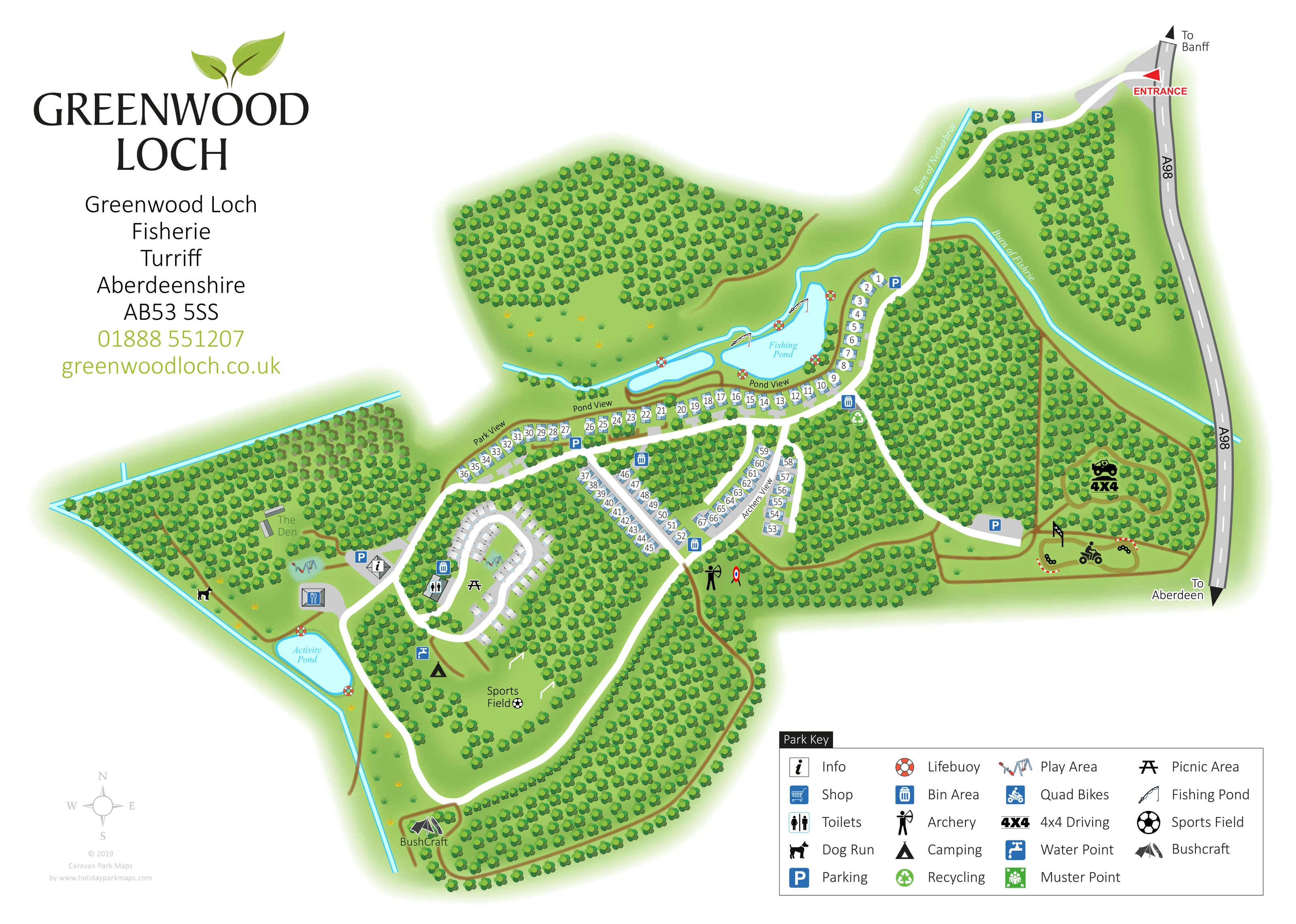
Extensive woodland
Dense clusters of stylised trees surround and divide the accommodation, ponds, activities and paths.
ILLUSTRATED PARK MAP · P484
Greenwood Loch, Fisherie, Turriff, Aberdeenshire · United Kingdom
 Enlarge the map ↗
A SENSE OF THE PLACE
Greenwood Loch is a family-oriented holiday park and activity centre near Turriff in Aberdeenshire. Holiday homes, touring pitches and camping provide several ways to stay.
Forest walks and an activity pond form part of the grounds, with a zip line among the advertised activities. Fully serviced hardstanding touring spaces and electric camping options support visitors bringing their own accommodation.
LOOK CLOSER
Dense clusters of stylised trees surround and divide the accommodation, ponds, activities and paths.
Named blue watercourses run through the northern and eastern grounds, with further blue channels along the western side.
A large irregular pond beside Pond View is labelled Fishing Pond and carries fishing-rod symbols; a smaller elongated pool sits immediately to its west.
A separate rounded pond lies in the western recreation area near the shop, play area and dog run.
Repeated red-and-white lifebuoy symbols appear around the fishing and activity waters.
An information symbol marks a small building beside parking at the western end of the main accommodation route.
The shop symbol is placed on a building in the western amenity cluster, close to the activity pond.
A toilet symbol marks a building on the western edge of the touring enclosure.
Dense clusters of stylised trees surround and divide the accommodation, ponds, activities and paths.
Named blue watercourses run through the northern and eastern grounds, with further blue channels along the western side.
A large irregular pond beside Pond View is labelled Fishing Pond and carries fishing-rod symbols; a smaller elongated pool sits immediately to its west.
A separate rounded pond lies in the western recreation area near the shop, play area and dog run.
Repeated red-and-white lifebuoy symbols appear around the fishing and activity waters.
An information symbol marks a small building beside parking at the western end of the main accommodation route.
The shop symbol is placed on a building in the western amenity cluster, close to the activity pond.
A toilet symbol marks a building on the western edge of the touring enclosure.
Small swing and seesaw illustrations identify the play area near The Den and the information point.
A picnic-table symbol appears in the grassy centre of the touring loop.
A dog symbol identifies a waterside clearing on the western side of the grounds.
A labelled grassy field south of the touring pitches includes a football symbol and illustrated goals.
An archer and target identify an activity clearing below the Archers View accommodation.
A quad-bike symbol and chequered markers identify a looping track in the eastern activity area.
A vehicle and bold 4X4 symbol mark a separate wooded driving circuit beside the eastern boundary.
A labelled bushcraft clearing with a shelter-and-tools illustration lies at the southern end of the woodland path network.
A small group of structures in the western woodland is labelled The Den; its specific function is not stated.
A blue tap symbol is positioned beside the camping area south of the touring loop.
Blue bin symbols are distributed at accommodation junctions and beside the touring area.
A muster-point symbol appears near the main junction below the pond-side accommodation.
Recycling is included in the Park Key; a separate corresponding location is not clearly identifiable in the overview.
Blue P symbols mark parking near the entrance, pond-side accommodation, western amenities and eastern activity area.
A red entrance arrow marks the connection to the A98 at the upper right, with external directions towards Banff and Aberdeen.
Broad white roads connect the entrance, pond-side plots, branching residential lanes, touring loop and southern grounds.
Narrow brown lines link clearings and follow woodland edges; eastern loops also describe the vehicle activity circuits.
Advertised in the supplied park information, but not separately identified on this artwork.
READING THE MAP
This illustrated map of Greenwood Loch brings together holiday accommodation, woodland and outdoor activities at Fisherie, near Turriff in Aberdeenshire. The plan follows the park from its A98 entrance through tree-lined roads to pond-side holiday homes, a separate touring enclosure and a camping area beside the sports field. Two different water destinations help structure the map: the fishing pond sits alongside Pond View, while the activity pond anchors the western amenity area.
The design gives the park’s recreation spaces as much attention as its accommodation. Archery, quad bikes, 4x4 driving and bushcraft are shown in distinct clearings, with play, picnic and dog-run symbols providing further landmarks. Bright blue water, broad white roads and dense green tree canopies make these relationships easy to follow.
A large Park Key explains the service and activity symbols, while numbered plots and named roads support more precise navigation. The leaf-branded title panel balances the detailed plan with clear park identification, making this a useful example for wooded holiday parks that need to explain both places to stay and things to do.
The map is arranged as a single overhead plan, with the entrance at the upper right and the main visitor facilities towards the left. The A98 forms a clear eastern reference, labelled with directions towards Banff and Aberdeen. From the red entrance arrow, a broad white road curves through woodland, crosses a blue watercourse and reaches the fishing pond and accommodation spine.
Pond View follows the water’s southern edge and turns north beside it. Park View extends west, while Archers View identifies the branching accommodation lanes below the central junction. Small pale holiday-home illustrations carry white number discs, with trees and grey plot aprons separating neighbouring units. Further west, touring caravans occupy an oval road layout around a grassy centre marked for picnics. Camping and a water point appear immediately south, near the labelled sports field and its goal illustrations.
The western recreation cluster includes an information point, shop, play equipment, dog run and the separately labelled Activity Pond. The Den is shown among nearby trees. At the opposite end of the plan, quad-bike and 4x4 symbols distinguish two wooded driving circuits. An archer and target mark another clearing, and brown paths continue around the southern woodland to the bushcraft area.
Parking and bin symbols recur at useful junctions, toilets are marked beside the touring enclosure, and lifebuoys are drawn around the water. A four-column Park Key occupies the lower-right corner. The large Greenwood Loch identity panel fills the upper-left white space, with a compass and designer credit below. The accompanying detail views enlarge portions of this same artwork rather than showing additional park sections.
KEEP EXPLORING
Chosen for shared landscapes, accommodation or facilities.
 Explore the map ↗
United Kingdom
A lakeside holiday-park and fishery map with numbered accommodation, fishing positions and clearly grouped visitor services.
 Explore the map ↗
United Kingdom
A woodland estate park map combining caravan loops, touring pitches, riverside paths and Bruce’s Cave landmarks.
 Explore the map ↗
United Kingdom
Trevornick’s colour-coded park map, with mixed accommodation, fishing ponds, golf and wooded trails.
Features may come from the sample artwork, its key or published park information. Approximate numbers describe the drawing and may cover only part of a park. They are intended to help you compare map examples. Current facilities and booking information should be checked with the park.
TAKE A CLOSER LOOK
View the illustrated map in detail or choose a file to download. These are sample maps; contact the park for current visitor information.


LET’S MAP YOUR PARK
For a map quotation, find your park and draw a rough boundary around it. The area you select helps us work out the design time and price.
Draw your park for a quote ↗Or talk to our map designers
01751 473136