
Boundary trees and scattered planting
Stylised trees form a substantial band along the upper boundary and indented left edge, with smaller clusters and individual trees among the homes.
ILLUSTRATED PARK MAP · U-J477
Lodge Park, Caterall Gates Lane, Caterall, Preston · United Kingdom
 Enlarge the map ↗
A SENSE OF THE PLACE
Lodge Park is a small residential park-home development at Catterall near Garstang in Lancashire. It sits within an established residential area, with the market town accessible by road or bus.
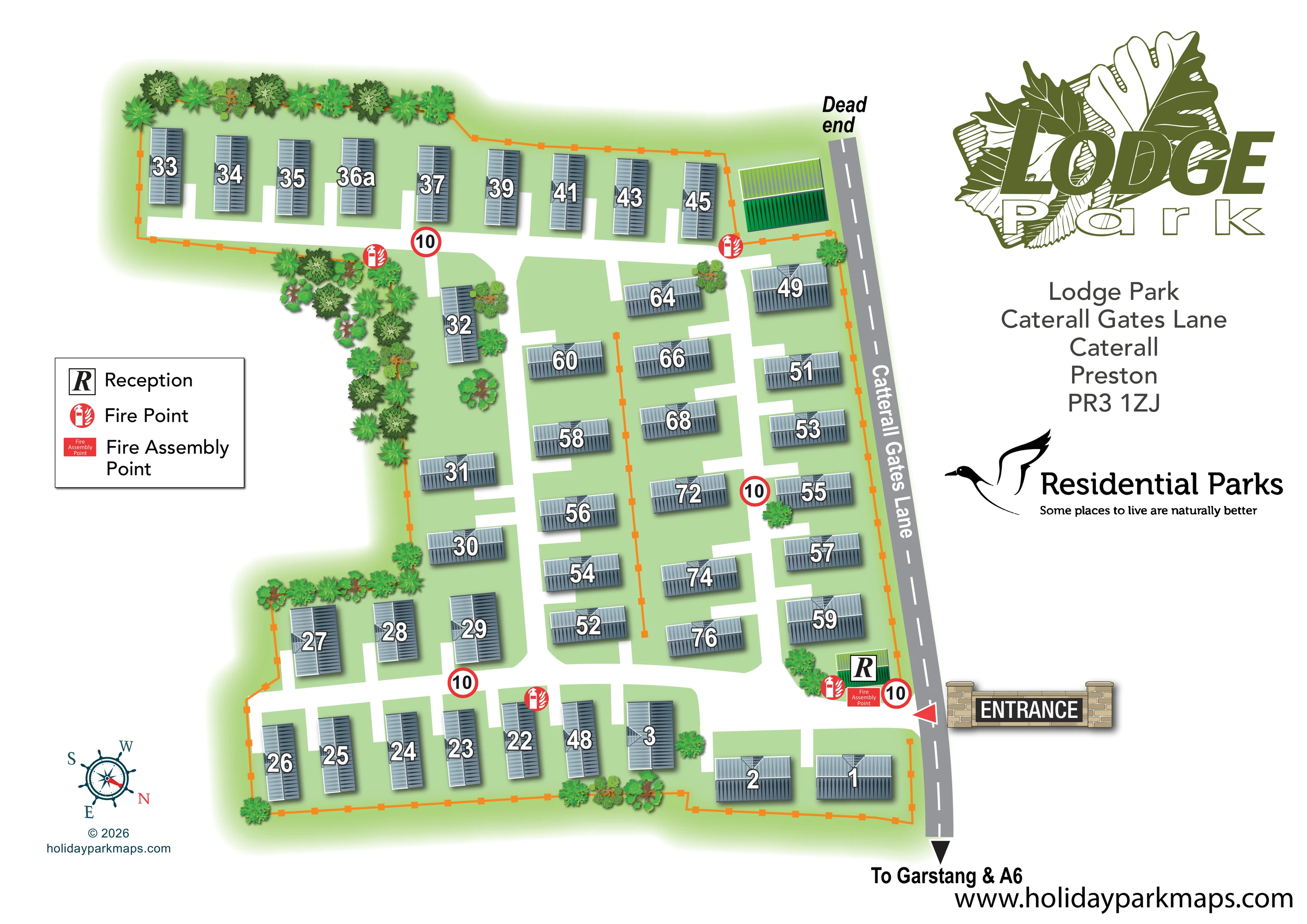
The map illustrates the arrangement of homes and internal access routes. This entry presents a residential site-map example, rather than holiday accommodation or a camping destination.
LOOK CLOSER
Stylised trees form a substantial band along the upper boundary and indented left edge, with smaller clusters and individual trees among the homes.
An orange line with square post-like marks follows the irregular perimeter and also divides part of the central plot arrangement.
A green-roofed building marked with a boxed R stands immediately inside the entrance beside Catterall Gates Lane.
Repeated red extinguisher symbols identify fire points near the entrance, along the lower access road and at the upper part of the site.
A red labelled assembly-point marker appears beside reception at the entrance.
A large illustrated entrance sign and red arrow identify the connection from Catterall Gates Lane to the internal road network.
White roads form linked longitudinal aisles and cross-connections, with short white branches leading towards individual homes.
The adjoining lane runs down the right side of the plan as a grey road with a dashed white centre line.
A green-roofed building marked with a boxed R stands immediately inside the entrance beside Catterall Gates Lane.
Repeated red extinguisher symbols identify fire points near the entrance, along the lower access road and at the upper part of the site.
A red labelled assembly-point marker appears beside reception at the entrance.
A large illustrated entrance sign and red arrow identify the connection from Catterall Gates Lane to the internal road network.
White roads form linked longitudinal aisles and cross-connections, with short white branches leading towards individual homes.
The adjoining lane runs down the right side of the plan as a grey road with a dashed white centre line.
A black arrow at the lower end of Catterall Gates Lane is labelled To Garstang & A6.
The upper end of the depicted external lane is labelled Dead end.
Red-ringed signs displaying 10 punctuate the entrance and internal roads; no unit is printed.
Stylised trees form a substantial band along the upper boundary and indented left edge, with smaller clusters and individual trees among the homes.
An orange line with square post-like marks follows the irregular perimeter and also divides part of the central plot arrangement.
A separate green-roofed rectangular building appears at the upper-right corner beside the lane. Its function is not identified.
READING THE MAP
This illustrated map of Lodge Park presents a small residential park-home development at Catterall near Garstang in Lancashire. Rather than organising holiday pitches or leisure attractions, it concentrates on the everyday task of finding a home, identifying reception and understanding the internal access roads. Roughly 40 homes are represented by blue-grey roof illustrations, with prominent numbers placed directly on each building.
The plan has a distinctive stepped outline: a long row of homes stretches across the top, while linked rows and access aisles fill the broader lower section. Catterall Gates Lane provides a clear reference along the right-hand edge, with the entrance picked out by a red arrow and an illustrated brick sign. Trees, pale-green plot spaces and an orange boundary line give the arrangement a landscaped character without competing with the labels.
A compact safety legend sits to the left, while Lodge Park and Residential Parks branding occupy a separate column on the right. The result is a residential mapping example built around numbered destinations, a recognisable arrival point and a straightforward road network.
The map shows the complete bounded residential layout on a single landscape-format page. Its irregular footprint includes a long upper arm, an indented planted edge on the left and a broader lower section beside Catterall Gates Lane. White internal roads connect the entrance to several longitudinal aisles and cross-roads. Short branches extend towards the individual homes, making the relationship between each numbered property and its approach easy to follow.
Home illustrations change orientation between the perimeter and central rows. Their blue-grey pitched roofs contain ridge lines, graphic roof textures and subtle shadows, with large white, dark-outlined numbers laid over them. Green space separates the buildings. An orange boundary line with square post-like marks follows the site edge and continues through part of the centre.
Reception is distinguished by a green roof and boxed R beside the entrance. A fire assembly marker is placed nearby, and red fire-point symbols recur around the site. Red-ringed signs displaying 10 appear along the access roads. A second green-roofed building at the upper-right corner is shown without a function label.
The adjoining lane uses a contrasting grey surface and dashed centre line. Its upper end is labelled Dead end, while a lower arrow points towards Garstang and the A6. Planting is strongest along the upper boundary and recessed left edge, with smaller tree clusters between homes. The left-hand legend and compass balance the large park logo, address and operator branding on the right. All detail views enlarge portions of this same plan; there is no separate inset or additional site variant.
KEEP EXPLORING
Chosen for shared landscapes, accommodation or facilities.
 Explore the map ↗
United Kingdom
Illustrated Sanday aire map with a seasonal maze, café barn and motorhome service area.
 Explore the map ↗
United Kingdom
Illustrated coastal campsite plan with named fields, electric pitch colours, beach routes and the Afon Hen.
 Explore the map ↗
United Kingdom
A woodland touring-park map with colour-coded pitches, a stream and footprint-marked walks.
Features may come from the sample artwork, its key or published park information. Approximate numbers describe the drawing and may cover only part of a park. They are intended to help you compare map examples. Current facilities and booking information should be checked with the park.
LET’S MAP YOUR PARK
For a map quotation, find your park and draw a rough boundary around it. The area you select helps us work out the design time and price.
Draw your park for a quote ↗Or talk to our map designers
01751 473136