
Nine bird-named areas
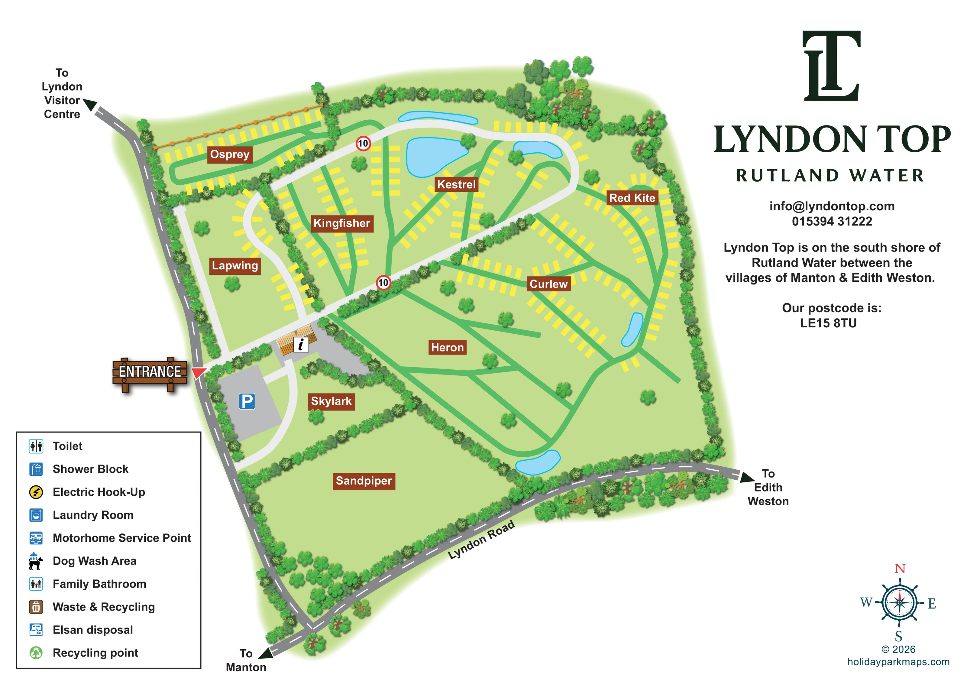
Sandpiper, Skylark, Heron, Curlew, Red Kite, Kestrel, Kingfisher, Lapwing and Osprey provide the main spatial reference system.
ILLUSTRATED PARK MAP · P199
South shore of Rutland Water, between Manton and Edith Weston · United Kingdom
 Enlarge the map ↗
A SENSE OF THE PLACE
Lyndon Top Caravan and Camping Park extends towards the southern shore of Rutland Water. Its broad, open setting offers lake views and space for family, couple and solo camping breaks.
Washroom facilities include showers and heated floors. The park's focus is a quieter stay beside the water, with the map helping visitors understand the camping areas and the layout across the grounds.
LOOK CLOSER
Sandpiper, Skylark, Heron, Curlew, Red Kite, Kestrel, Kingfisher, Lapwing and Osprey provide the main spatial reference system.
Five blue pond-like shapes appear within the grounds, including a cluster around Kestrel and others near the eastern and southern routes. Their use is not specified.
Dense illustrated planting encloses the site and divides fields, with individual trees scattered across the grass and larger clusters along parts of the boundary.
The branding and location paragraph establish the Rutland Water setting. The reservoir shoreline itself is not drawn.
A wooden-style ENTRANCE sign and red triangular pointer mark the arrival point from the road along the western edge.
A grey parking area with a blue P symbol lies just inside the entrance, beside Skylark.
A small orange-roofed building on a grey forecourt carries an information symbol near the entrance and main internal road junction.
Broad pale routes connect the entrance to the northern fields, while green loops and branching lines organise access within the accommodation areas.
Sandpiper, Skylark, Heron, Curlew, Red Kite, Kestrel, Kingfisher, Lapwing and Osprey provide the main spatial reference system.
Five blue pond-like shapes appear within the grounds, including a cluster around Kestrel and others near the eastern and southern routes. Their use is not specified.
Dense illustrated planting encloses the site and divides fields, with individual trees scattered across the grass and larger clusters along parts of the boundary.
A wooden-style ENTRANCE sign and red triangular pointer mark the arrival point from the road along the western edge.
A grey parking area with a blue P symbol lies just inside the entrance, beside Skylark.
A small orange-roofed building on a grey forecourt carries an information symbol near the entrance and main internal road junction.
Broad pale routes connect the entrance to the northern fields, while green loops and branching lines organise access within the accommodation areas.
Two red-bordered circular signs marked 10 appear on the main internal route. No unit is printed.
Lyndon Road runs along the southern edge. Directional arrows identify Manton, Edith Weston and Lyndon Visitor Centre; the visitor centre is an off-map destination.
Three washroom symbols are defined in the key, but corresponding positions are not marked on the plan.
A yellow circular lightning symbol is included in the legend. The yellow rectangular pitch markers are a different symbol and are not explicitly identified as hook-up pitches.
A laundry symbol appears in the key without a mapped location.
Both servicing facilities are listed in the key, without corresponding location symbols on the plan.
A dog-and-shower pictogram is defined in the legend, but no position is shown.
The key contains both Waste & Recycling and Recycling point entries; their locations are not plotted.
The branding and location paragraph establish the Rutland Water setting. The reservoir shoreline itself is not drawn.
READING THE MAP
This illustrated map of Lyndon Top Caravan Park presents a broad, field-based site on the south shore of Rutland Water, between Manton and Edith Weston. Rather than relying on numbered plots, it uses nine bird-named areas to give visitors a clear set of destinations, from Osprey and Kingfisher to Skylark and Sandpiper.
The plan brings together an entrance-side parking area, an information building, pale internal roads and green access loops. Bright yellow pitch markers follow the curves and branches of the routes, while larger open fields preserve the sense of space across the southern part of the grounds. Illustrated hedgerows, tree belts and small blue water features help distinguish one area from another without overwhelming the layout.
A substantial branding column gives the park name and local setting their own space alongside the plan. Direction arrows towards Manton, Edith Weston and Lyndon Visitor Centre place the park within its surroundings. The result is a useful sample for caravan and camping parks that need to explain named fields and arrival routes within an open landscape.
The single landscape page places the illustrated grounds across the left and centre, with Lyndon Top branding and location information on the right. A wooden-style entrance sign points to the western arrival junction. Immediately inside, a blue parking symbol identifies a grey parking area beside Skylark, and an information symbol marks a small orange-roofed building on a separate forecourt.
From this arrival hub, pale roads lead into the park and connect the northern sections. Green tracks form loops, forks and long diagonal branches within the fields. Osprey occupies a narrow, hedge-enclosed section at the upper left; Lapwing follows a curved pale road below it. Kingfisher and Kestrel fill much of the central northern ground, while Red Kite and Curlew extend across the eastern side. Yellow rectangles indicate schematic pitch positions along these routes, without distinguishing accommodation types or assigning plot numbers.
Heron has a more open branching layout, while Skylark and the broad Sandpiper field contain no individual yellow pitch markers. Dense tree and shrub illustrations separate areas and trace the site boundary. Five small blue water shapes add recognisable landmarks, particularly around Kestrel and the eastern and southern loops.
Outside the grounds, dark grey roads with dashed centre lines lead towards Manton, Edith Weston and Lyndon Visitor Centre. Lyndon Road is labelled along the southern edge. The lower-left legend lists washrooms, electric hook-up, laundry, motorhome servicing, dog washing and waste facilities, although their symbols are not placed within the plan. A decorative compass rose completes the lower-right corner. The overall composition combines a simplified field layout with more detailed landscape illustration.
KEEP EXPLORING
Chosen for shared landscapes, accommodation or facilities.
 Explore the map ↗
United Kingdom
Colour-coded campsite map with riverside pitches, bell tents, a swimming pool and fishing lake.
 Explore the map ↗
United Kingdom
Coastal park map with static-caravan rows, touring pitches, a camping field and two leisure clusters.
 Explore the map ↗
United Kingdom
A wooded Allerton park plan with colour-coded neighbourhoods, touring pitches and a central facilities hub.
Features may come from the sample artwork, its key or published park information. Approximate numbers describe the drawing and may cover only part of a park. They are intended to help you compare map examples. Current facilities and booking information should be checked with the park.
LET’S MAP YOUR PARK
For a map quotation, find your park and draw a rough boundary around it. The area you select helps us work out the design time and price.
Draw your park for a quote ↗Or talk to our map designers
01751 473136