
Tree and hedge boundaries
Dense illustrated trees enclose the park and form internal screens between pitch areas.
ILLUSTRATED PARK MAP · P533
Lydford Caravan & Camping Park, Lydford, Nr Okehampton, Devon · United Kingdom
 Enlarge the map ↗
A SENSE OF THE PLACE
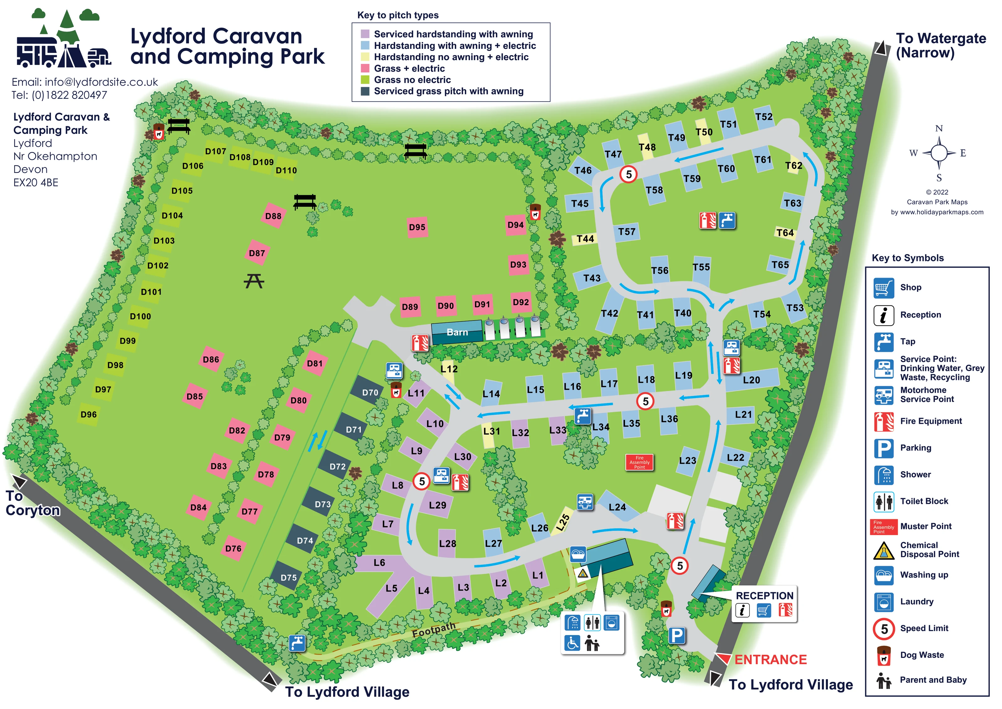
Lydford Caravan and Camping Park is located near Okehampton in Devon. Its facilities are grouped near the entrance, making them accessible from the different camping areas.
A shop stocks food and camping supplies, while heated showers, toilets, a wet room, laundry and dishwashing spaces support stays. The map helps visitors find these shared facilities and understand the pitch layout.
LOOK CLOSER
Dense illustrated trees enclose the park and form internal screens between pitch areas.
The western side is drawn as a broad green field with coloured grass pitches, scattered seating and planted divisions.
A labelled callout identifies reception in the building beside the lower-right entrance.
The shop symbol appears in the reception building callout.
A parking symbol is positioned just inside the entrance, near reception.
A pointer panel links shower and toilet symbols to the shared facilities building near the southern edge.
A washing-machine symbol is included in the shared facilities building callout.
The parent-and-baby symbol appears in the shared facilities callout.
A labelled callout identifies reception in the building beside the lower-right entrance.
The shop symbol appears in the reception building callout.
A parking symbol is positioned just inside the entrance, near reception.
A pointer panel links shower and toilet symbols to the shared facilities building near the southern edge.
A washing-machine symbol is included in the shared facilities building callout.
The parent-and-baby symbol appears in the shared facilities callout.
A wheelchair symbol is shown in the facilities callout. The artwork does not specify the detailed provision or establish wider site accessibility.
A washing-up symbol marks the shared facilities building beside the southern footpath.
A yellow triangular disposal symbol is positioned beside the shared facilities building.
Tap symbols appear in the upper pitch loop, central pitch area and beside the southern footpath.
Several service-point symbols are distributed through the pitch areas; the key defines their combined drinking-water, grey-waste and recycling function.
A distinct motorhome service symbol is positioned beside the lower internal road.
Repeated red fire-equipment symbols identify points around the road network, barn and reception.
A red Fire Assembly Point panel marks the open grass within the lower road loop.
Dog-waste symbols appear near reception and at several field edges and internal boundaries.
A teal-roofed building labelled Barn sits between the western grass field and the eastern road-served pitches. Its use is not specified.
Bench and picnic-table illustrations are placed in the western grass field and along its northern edge.
Dense illustrated trees enclose the park and form internal screens between pitch areas.
The western side is drawn as a broad green field with coloured grass pitches, scattered seating and planted divisions.
A prominent red entrance label and triangular marker identify the approach at the lower-right corner.
Pale-grey roads form linked loops through the eastern pitches. Cyan arrows indicate mapped travel directions, with paired arrows on some connecting sections.
Repeated red-ringed signs displaying 5 are placed along the internal roads.
A labelled yellow route with an orange dashed centre runs along the southern boundary towards Lydford Village.
Edge labels identify routes towards Lydford Village and Coryton, and towards Watergate with the qualification Narrow.
READING THE MAP
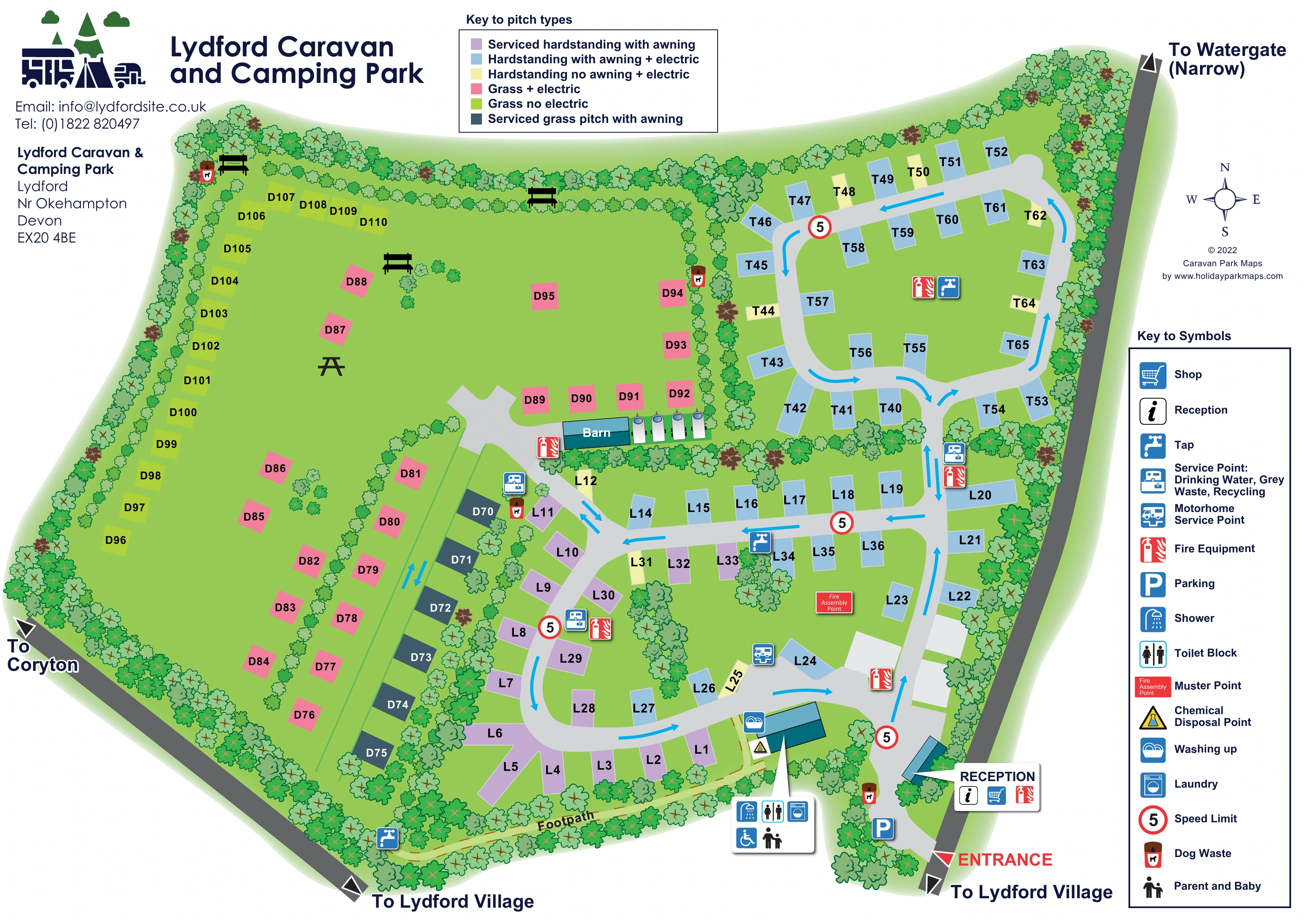
This illustrated map of Lydford Caravan and Camping Park, near Okehampton in Devon, brings together pitch selection, arrival information and everyday visitor wayfinding. The tree-lined plan has two distinct characters: an open grass field on the western side and a network of curving roads serving the more closely arranged pitches to the east. Approximately 100 marked pitches give the artwork a substantial but manageable level of detail.
A six-colour key distinguishes grass and hardstanding options, electric provision, servicing and awning allowance. Rather than filling the site with caravan illustrations, the design uses simple pitch blocks and bold references, leaving room for routes and facilities to remain clear. Reception and parking sit beside the prominently marked entrance, while a nearby callout identifies the shared shower, toilet and laundry facilities.
The map also shows water and waste service points, a dedicated motorhome service point, outdoor seating and a footpath towards Lydford Village. Dense illustrated planting gives the plan its green setting, while cyan road arrows, red safety markers and two separate legends keep the practical information distinct.
The plan is arranged around a lower-right entrance leading past parking and the reception building. From here, a pale-grey internal road continues up the eastern side and connects two looping pitch areas. Cyan arrows describe the mapped circulation, and repeated red-ringed 5 signs provide a consistent road marker. Large white callouts point to reception and the shared facilities building, allowing several service symbols to sit together without obscuring the roofs.
Across the eastern half, coloured rectangular pitches follow the road edges and curves. Light blue is the dominant hardstanding colour, with lavender and pale yellow identifying other specifications. The western half is more open: pink electric grass pitches and lime non-electric grass pitches occupy a broad field, while slate-blue serviced grass pitches form a narrow row beside an internal planted boundary. Benches and a picnic table add recognisable landmarks without replacing the functional pitch notation.
The labelled barn sits near the meeting point of the two areas. Water taps, combined drinking-water, grey-waste and recycling points, fire equipment and dog-waste bins are distributed around the site. A separate motorhome service point appears beside the lower loop, and the fire assembly point is marked on nearby open grass. The southern facilities building is associated with showers, toilets, laundry, washing-up, parent-and-baby and wheelchair symbols, with chemical disposal marked alongside.
A yellow footpath follows the southern boundary towards Lydford Village. External road labels also point towards Coryton and Watergate, the latter marked Narrow. The upper pitch key and right-hand symbol key support the main plan, with a compass completing orientation. The enlarged detail views show these same legends and neighbouring pitches; they are crops of one artwork, not separate map variants.
KEEP EXPLORING
Chosen for shared landscapes, accommodation or facilities.
 Explore the map ↗
United Kingdom
Colour-coded campsite map with riverside pitches, bell tents, a swimming pool and fishing lake.
 Explore the map ↗
United Kingdom
Coastal park map with static-caravan rows, touring pitches, a camping field and two leisure clusters.
 Explore the map ↗
United Kingdom
A wooded Allerton park plan with colour-coded neighbourhoods, touring pitches and a central facilities hub.
Features may come from the sample artwork, its key or published park information. Approximate numbers describe the drawing and may cover only part of a park. They are intended to help you compare map examples. Current facilities and booking information should be checked with the park.
TAKE A CLOSER LOOK
View the illustrated map in detail or choose a file to download. These are sample maps; contact the park for current visitor information.


LET’S MAP YOUR PARK
For a map quotation, find your park and draw a rough boundary around it. The area you select helps us work out the design time and price.
Draw your park for a quote ↗Or talk to our map designers
01751 473136
 lydfordmap_large.png