
Two dog-walking areas
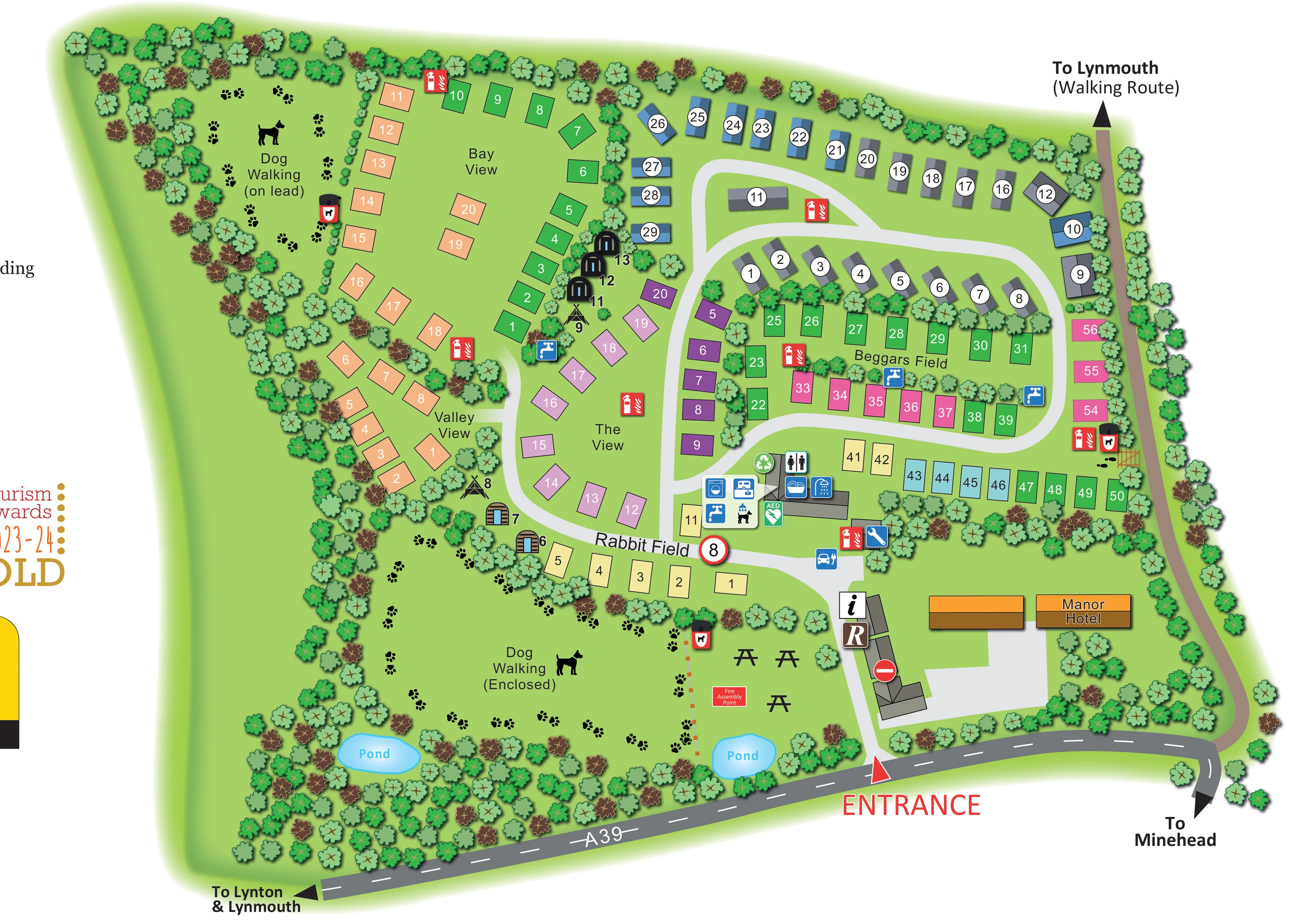
The upper-left area is labelled Dog Walking (on lead), while the larger lower-left area is labelled Dog Walking (Enclosed). Paw prints and dog silhouettes distinguish both spaces.
ILLUSTRATED PARK MAP · P200
Manor Farm, Lynton, North Devon · United Kingdom
 Enlarge the map ↗
A SENSE OF THE PLACE
Lynmouth Holiday Retreat, formerly Channel View, overlooks the Bristol Channel near Lynton. Footpaths through Exmoor's coastal and moorland scenery are a defining feature of the location.
Touring and camping pitches, pods, glamping accommodation and rental caravans offer different ways to stay. Washrooms include family facilities, and the map helps visitors locate accommodation and shared spaces within the retreat.
LOOK CLOSER
The upper-left area is labelled Dog Walking (on lead), while the larger lower-left area is labelled Dog Walking (Enclosed). Paw prints and dog silhouettes distinguish both spaces.
Two labelled blue ponds sit within the planted lower edge of the plan.
Dense tree symbols enclose the park and separate several accommodation rows and open spaces.
An information symbol and an R marker identify the arrival-side building cluster.
Toilet and shower pictograms mark the central shared-services building.
A dish-and-basin pictogram sits alongside the washroom symbols.
A washing-machine symbol marks the central service cluster.
Blue tap symbols appear at the service building and beside several pitch groups.
An information symbol and an R marker identify the arrival-side building cluster.
Toilet and shower pictograms mark the central shared-services building.
A dish-and-basin pictogram sits alongside the washroom symbols.
A washing-machine symbol marks the central service cluster.
Blue tap symbols appear at the service building and beside several pitch groups.
A caravan-and-disposal pictogram appears in the central facilities panel; its exact wording is not visible.
A dog beneath a shower pictogram is shown within the shared-services panel.
A green recycling symbol marks the service-building area.
A blue car-and-plug symbol is positioned beside the arrival route.
A spanner pictogram marks a small building near the arrival-side services.
A green AED marker is shown beside the washroom building.
Red extinguisher symbols are distributed across the accommodation areas; a labelled assembly point lies on the lawn near the entrance.
The upper-left area is labelled Dog Walking (on lead), while the larger lower-left area is labelled Dog Walking (Enclosed). Paw prints and dog silhouettes distinguish both spaces.
Red-and-black dog-bin symbols are placed beside the walking areas and the eastern pedestrian access.
Picnic-table silhouettes occupy the lawn between the enclosed dog-walking area and the entrance buildings.
Two labelled blue ponds sit within the planted lower edge of the plan.
Dense tree symbols enclose the park and separate several accommodation rows and open spaces.
An orange-roofed building labelled Manor Hotel is shown beside the entrance forecourt.
The entrance connects to the A39, with arrows towards Lynton and Lynmouth to the left and Minehead to the right.
A brown route follows the eastern boundary and ends in an outward arrow labelled To Lynmouth (Walking Route).
An 8 speed-limit-style marker appears on the internal road, with a no-entry symbol at the arrival building cluster.
READING THE MAP
This illustrated map of Lynmouth Holiday Retreat brings together a varied accommodation layout and a notably green setting near Lynton in North Devon. The plan shows caravan-style holiday units, coloured touring and camping pitch areas, and a small group of pods and tipi-style accommodation, all organised around curving internal roads. Named areas including Bay View, Valley View, The View, Beggars Field and Rabbit Field help visitors recognise different parts of the retreat rather than relying on pitch numbers alone.
The arrival sequence is particularly clear: a large red entrance marker leads from the A39 towards the reception and information buildings, with the Manor Hotel nearby. Shared facilities are grouped at a central junction, while two dog-walking areas occupy generous spaces on the western side. Ponds, picnic tables and dense illustrated planting give these open areas their own character.
A separate walking route towards Lynmouth extends along the eastern boundary. Together with road arrows towards Lynton, Lynmouth and Minehead, it connects the internal park plan to the surrounding coastal and Exmoor setting.
The map uses an overhead layout with lightly shaded buildings to make a complex mix of accommodation easy to distinguish. Blue- and grey-roofed caravan-style units sit around the upper road loop, each carrying a white circular number badge. Elsewhere, flat pitch rectangles in peach, green, purple, pink, yellow and turquoise form distinct rows and clusters. Large field names provide a second layer of orientation: Bay View and Valley View sit to the west, The View follows the central road, Beggars Field occupies the eastern loop, and Rabbit Field runs across the lower accommodation edge. Rounded pods and tipi-style symbols introduce a different visual vocabulary beside the western planting.
From the A39 entrance, the internal road passes the reception and information markers before reaching the shared-services building. Blue pictograms identify toilets, showers, washing-up, laundry and water, alongside a dog-wash illustration and a caravan disposal symbol. Recycling and AED markers use green, while fire points are picked out in red. An electric vehicle charging symbol and a maintenance spanner appear near the arrival-side junction.
The landscape is more than a decorative border. Tree belts separate accommodation groups and enclose two labelled dog-walking spaces, one marked on lead and the other enclosed. Dog silhouettes, paw prints and dog-bin symbols make their purpose immediately recognisable. Two bright blue ponds sit near the lower boundary, with picnic tables and a fire assembly point on the entrance-side lawn.
The dark A39 has dashed white road markings and destination arrows, contrasting with the pale internal roads and the brown walking route towards Lynmouth. The supplied views show one map artwork; the enlarged quadrants reveal its details rather than separate sections or additional accommodation.
KEEP EXPLORING
Chosen for shared landscapes, accommodation or facilities.
 Explore the map ↗
United Kingdom
Woodland-framed Barnsoul map with mixed accommodation, shared facilities and paw-marked walking routes.
 Explore the map ↗
United Kingdom
A woodland estate park map combining caravan loops, touring pitches, riverside paths and Bruce’s Cave landmarks.
 Explore the map ↗
United Kingdom
Trevornick’s colour-coded park map, with mixed accommodation, fishing ponds, golf and wooded trails.
Features may come from the sample artwork, its key or published park information. Approximate numbers describe the drawing and may cover only part of a park. They are intended to help you compare map examples. Current facilities and booking information should be checked with the park.
TAKE A CLOSER LOOK
View the illustrated map in detail or choose a file to download. These are sample maps; contact the park for current visitor information.


LET’S MAP YOUR PARK
For a map quotation, find your park and draw a rough boundary around it. The area you select helps us work out the design time and price.
Draw your park for a quote ↗Or talk to our map designers
01751 473136