
Central shared green space
A broad triangular lawn separates the diagonal caravan block from the lower frontage and contains the play area and a muster point.
ILLUSTRATED PARK MAP · P540
South Road, Brean, Somerset · United Kingdom
 Enlarge the map ↗
A SENSE OF THE PLACE
Merrybee Caravan Park is an ownership-focused holiday caravan park in Brean, Somerset. The village setting is close to the sandy beach and local amenities.
The park's published facilities include laundry, a children's play area and Wi-Fi. Its map shows the arrangement of privately owned holiday caravans and the routes connecting them with shared spaces.
LOOK CLOSER
A broad triangular lawn separates the diagonal caravan block from the lower frontage and contains the play area and a muster point.
Dense stylised trees outline most of the park perimeter, with smaller planted groups around the bungalow, lawn and road edges.
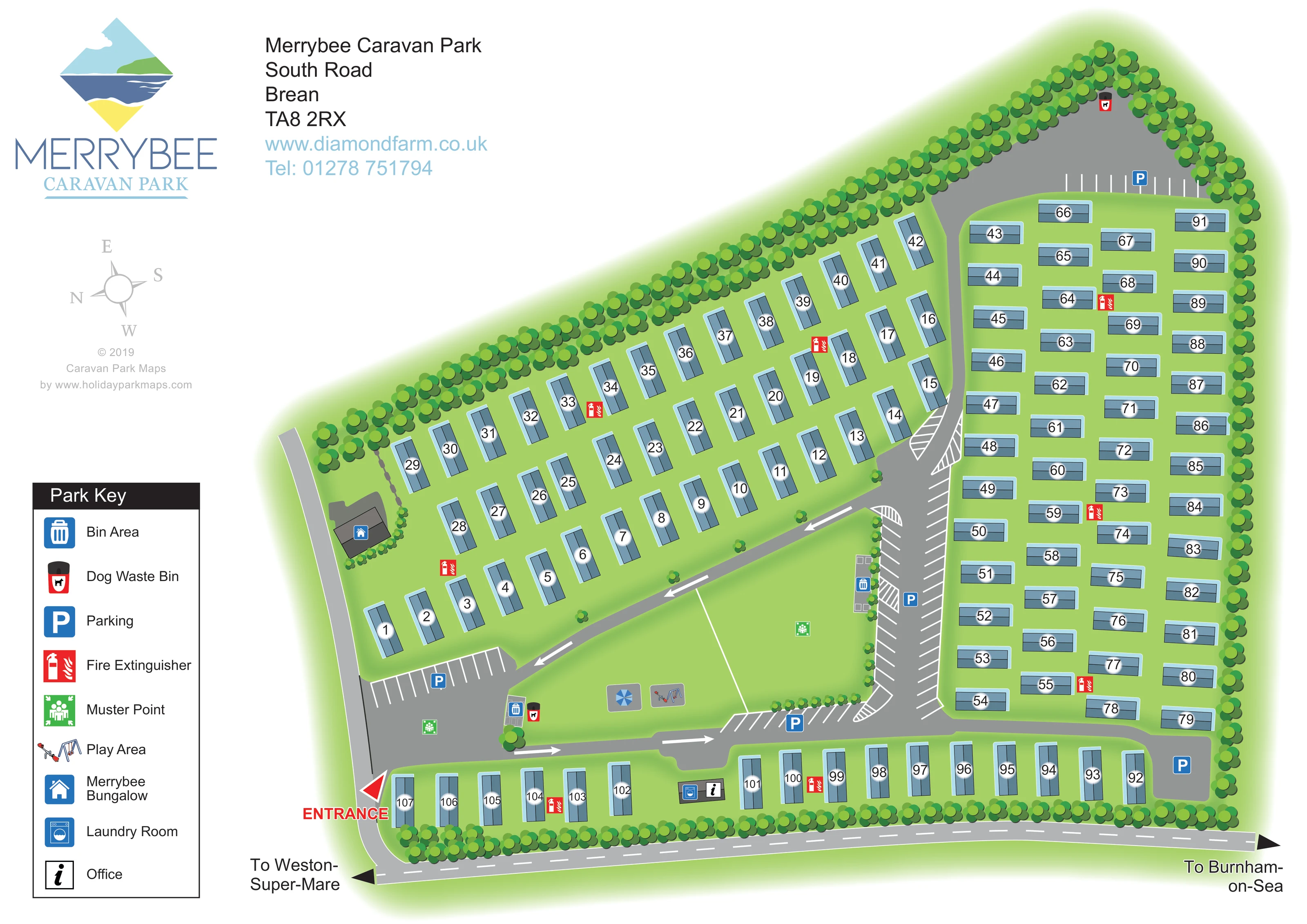
A prominent red arrow and ENTRANCE label mark the access from the road along the bottom of the plan.
Grey roads connect the entrance, lower frontage, central lawn and upper parking area. White directional arrows appear on the lower and diagonal routes.
Black arrows at opposite ends of the external road give onward directions to the two coastal towns.
Blue P symbols and white bay markings identify parking near the entrance, beside the central spine, along the lower road and at the far end of the park.
An information symbol marks the office in a small building beside the lower internal road, next to the laundry symbol.
A blue washing-machine symbol identifies the laundry room beside the office near the lower caravan row.
A prominent red arrow and ENTRANCE label mark the access from the road along the bottom of the plan.
Grey roads connect the entrance, lower frontage, central lawn and upper parking area. White directional arrows appear on the lower and diagonal routes.
Black arrows at opposite ends of the external road give onward directions to the two coastal towns.
Blue P symbols and white bay markings identify parking near the entrance, beside the central spine, along the lower road and at the far end of the park.
An information symbol marks the office in a small building beside the lower internal road, next to the laundry symbol.
A blue washing-machine symbol identifies the laundry room beside the office near the lower caravan row.
Illustrated swings and a seesaw sit on a small grey pad within the central green space, beside a separate blue-and-white parasol illustration.
A detached grey-roofed building beside the left-hand access road is identified by the house symbol in the key. Its accommodation or operational use is not specified.
Bin-area symbols appear around the central road and entrance-side lawn. Dog waste bins are shown near the entrance-side bin area and at the upper end of the park.
Red fire extinguisher symbols are distributed amongst the caravan rows.
Green assembly symbols mark points near the entrance parking and on the central lawn.
A broad triangular lawn separates the diagonal caravan block from the lower frontage and contains the play area and a muster point.
Dense stylised trees outline most of the park perimeter, with smaller planted groups around the bungalow, lawn and road edges.
READING THE MAP
This map of Merrybee Caravan Park in Brean, Somerset, presents an ownership-focused holiday caravan site as a clear, numbered plan. Its distinctive wedge-shaped outline is framed by illustrated trees, with blue-grey caravans arranged in diagonal rows, a more regular right-hand block and a row along the road frontage. A large central green creates a visual break between the accommodation areas and brings the children's play area into focus.
The entrance is picked out in red, while grey roads, white direction arrows and marked parking bays explain how the different parts of the park connect. The office, laundry room, Merrybee Bungalow, waste points and safety symbols are supported by a generous boxed key. Directions towards Weston-super-Mare and Burnham-on-Sea place the entrance road in its wider coastal context.
With the park's branding and contact details kept separate from the main plan, this sample shows how a compact caravan park map can combine plot-level navigation, shared facilities and a recognisable visual identity without relying on a photographic base.
The main plan fills the right-hand and lower portions of a landscape page. Its irregular boundary rises diagonally from the entrance side towards a rounded upper end, with dense bands of stylised trees enclosing most of the caravan areas. The accommodation is divided into three visually distinct arrangements: diagonal rows on the left, straighter rows on the right and a narrow frontage row along the bottom. Each caravan has a simplified blue-grey roof and a black number on a soft white disc.
Arrival is shown at the lower left, where a red arrow leads from the external road into the park. The internal road passes the frontage caravans and office/laundry building, then connects with the central parking-lined spine. A diagonal road borders the upper side of the shared lawn, and white arrows indicate movement along the illustrated routes. Parking is shown both through bay markings and blue P symbols, including areas near the entrance and at the upper end.
The central lawn contains illustrated swings and a seesaw, a nearby parasol graphic and a green muster-point symbol. Another muster point appears near the entrance parking. Bin areas, dog waste bins and red fire extinguisher symbols are distributed around the plan. Merrybee Bungalow is drawn separately beside the left-hand access road.
A large nine-entry key explains the facility symbols. Above it, the park logo, address and contact block sit in open white space alongside a rotated compass and designer credit. Destination arrows identify the road directions towards Weston-super-Mare and Burnham-on-Sea. The accompanying enlarged detail repeats the entrance and key from this same artwork; it is not a separate park section.
KEEP EXPLORING
Chosen for shared landscapes, accommodation or facilities.
 Explore the map ↗
United Kingdom
Coastal park map with static-caravan rows, touring pitches, a camping field and two leisure clusters.
 Explore the map ↗
United Kingdom
A wooded Allerton park plan with colour-coded neighbourhoods, touring pitches and a central facilities hub.
 Explore the map ↗
United Kingdom
Illustrated coastal holiday-home plan with dense alphanumeric plot labels, orange-roofed amenities, a numbered facility key and beach-side context.
Features may come from the sample artwork, its key or published park information. Approximate numbers describe the drawing and may cover only part of a park. They are intended to help you compare map examples. Current facilities and booking information should be checked with the park.
TAKE A CLOSER LOOK
View the illustrated map in detail or choose a file to download. These are sample maps; contact the park for current visitor information.


LET’S MAP YOUR PARK
For a map quotation, find your park and draw a rough boundary around it. The area you select helps us work out the design time and price.
Draw your park for a quote ↗Or talk to our map designers
01751 473136