
Railway corridor
A twin-rail and sleeper motif extends across the bottom of the plan, separated from the accommodation by planted boundaries.
ILLUSTRATED PARK MAP · P219
Shore Lane, Bolton-le-Sands, Carnforth, Lancashire · United Kingdom
 Enlarge the map ↗
A SENSE OF THE PLACE
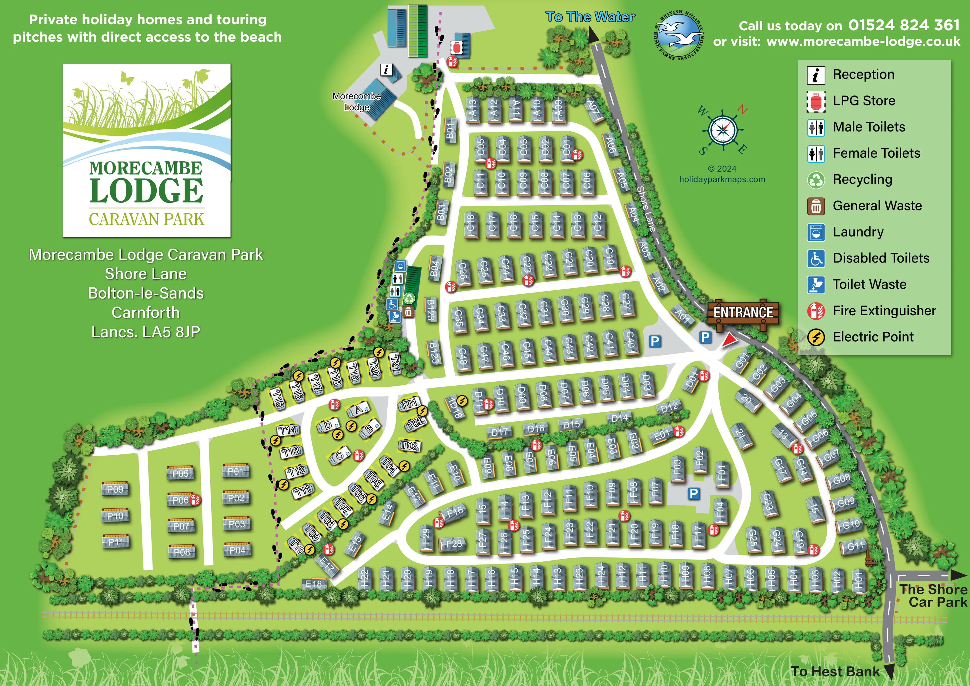
Morecambe Lodge Caravan Park lies on the edge of Morecambe Bay with direct access to the coast. The main park is reserved for holiday home owners, their families and friends.
Seasonal touring pitches provide another way to return regularly. The site focuses on a quieter coastal stay, with the map showing how the holiday homes, touring field and internal routes fit together.
LOOK CLOSER
A twin-rail and sleeper motif extends across the bottom of the plan, separated from the accommodation by planted boundaries.
Dense illustrated trees and shrubs frame the perimeter, screen Shore Lane and divide selected accommodation areas, including the separate left-hand enclosure.
An information symbol marks a small building beside the lodge and upper service yard.
A prominent blue-roofed building at the upper-left end of the plan is labelled 'Morecombe Lodge'; its specific visitor use is not stated.
A gas-cylinder symbol identifies the LPG store in the upper service-yard area.
Separate male and female toilet symbols are grouped at the green-roofed service building beside the touring area.
A wheelchair symbol at the same service building corresponds to the legend entry 'Disabled Toilets'.
A washing-machine symbol locates the laundry at the touring-side service building.
An information symbol marks a small building beside the lodge and upper service yard.
A prominent blue-roofed building at the upper-left end of the plan is labelled 'Morecombe Lodge'; its specific visitor use is not stated.
A gas-cylinder symbol identifies the LPG store in the upper service-yard area.
Separate male and female toilet symbols are grouped at the green-roofed service building beside the touring area.
A wheelchair symbol at the same service building corresponds to the legend entry 'Disabled Toilets'.
A washing-machine symbol locates the laundry at the touring-side service building.
A toilet-waste symbol appears in the service cluster beside the touring pitches.
Green recycling and brown general-waste symbols are grouped beside the service building.
Yellow lightning-bolt symbols are distributed through the touring area, with another shown close to the adjoining holiday-home section.
Red fire-extinguisher symbols recur throughout the holiday-home rows, touring area and upper service yard.
Blue P symbols mark grey parking pockets near the entrance and within the lower holiday-home area.
A timber-style entrance sign and red pointer identify the connection between Shore Lane and the main internal road junction.
A magenta dashed line with black footprints follows the left side of the main park, passes the touring area and continues across the railway corridor at the bottom of the drawing.
The headline states direct access to the beach, while an arrow at the upper end of Shore Lane reads 'To The Water'. The shoreline itself is not drawn.
At the lower-right edge, arrows point along Shore Lane towards Hest Bank and off to The Shore Car Park; these are directional references outside the internal park layout.
A twin-rail and sleeper motif extends across the bottom of the plan, separated from the accommodation by planted boundaries.
Dense illustrated trees and shrubs frame the perimeter, screen Shore Lane and divide selected accommodation areas, including the separate left-hand enclosure.
READING THE MAP
This illustrated map of Morecambe Lodge Caravan Park brings together a substantial private holiday-home layout, a smaller touring area and the routes connecting them. Set on the edge of Morecambe Bay at Bolton-le-Sands in Lancashire, the park’s coastal identity is expressed through the beach-access headline, the direction towards the water and a nautical compass.
The plan centres on the entrance from Shore Lane, then follows a network of white internal roads through rows of grey-roofed holiday homes. Touring caravans stand out on yellow pitch pads towards the left, close to a clearly marked service building. Trees and shrubs define the park boundary and separate selected accommodation groups, while a railway corridor provides a useful landmark along the bottom of the drawing.
A large pictorial key explains reception, toilets, laundry, waste facilities, electric points and fire-extinguisher locations. The combination of numbered accommodation, parking markers and a distinctive footprint-marked walking route makes this a useful sample for parks needing both plot-level orientation and a clear account of their wider setting.
The single landscape-format artwork presents the park as an overhead plan, with slightly raised caravan and building illustrations adding depth. Its footprint broadens towards the bottom of the page and narrows towards the lodge and reception area at the top. Shore Lane runs down the right-hand side, with a timber-style entrance sign and red pointer marking the main arrival junction. Grey parking pockets sit beside this junction and within the lower accommodation area.
Most holiday homes are arranged in closely spaced rows reached by broad white roads. Curved connections break up the grid and lead around planted islands. A separate enclosure on the left contains more widely spaced holiday homes served by straight road spurs. Immediately alongside it, touring caravans occupy yellow pads around a compact loop and adjoining lanes. Their bold outlined references contrast with the white references printed on the holiday-home roofs.
The touring-side service building carries grouped symbols for laundry, male and female toilets, an accessible toilet, toilet-waste disposal, recycling and general waste. Yellow electric-point symbols appear around the touring pitches, while red fire-extinguisher markers recur across the wider site. Reception and the LPG store are identified in the upper building cluster.
A magenta dashed route with black footprints follows the left edge of the main park and continues across the railway corridor shown along the lower boundary. External arrows indicate the water, Hest Bank and The Shore Car Park. The coastline is referenced rather than illustrated as a bay panorama. Dense tree belts, a botanical page footer, the large park logo and the pale-green facility key complete a composition that balances accommodation detail with broader orientation.
KEEP EXPLORING
Chosen for shared landscapes, accommodation or facilities.
 Explore the map ↗
United Kingdom
Coastal park map with static-caravan rows, touring pitches, a camping field and two leisure clusters.
 Explore the map ↗
United Kingdom
Coastal park plan with colour-coded pitches, named neighbourhoods and a Morecambe Bay walking route.
 Explore the map ↗
United Kingdom
Illustrated touring-park plan with facilities, public footpaths and adjoining field-access details.
Features may come from the sample artwork, its key or published park information. Approximate numbers describe the drawing and may cover only part of a park. They are intended to help you compare map examples. Current facilities and booking information should be checked with the park.
LET’S MAP YOUR PARK
For a map quotation, find your park and draw a rough boundary around it. The area you select helps us work out the design time and price.
Draw your park for a quote ↗Or talk to our map designers
01751 473136