
Wooded perimeter
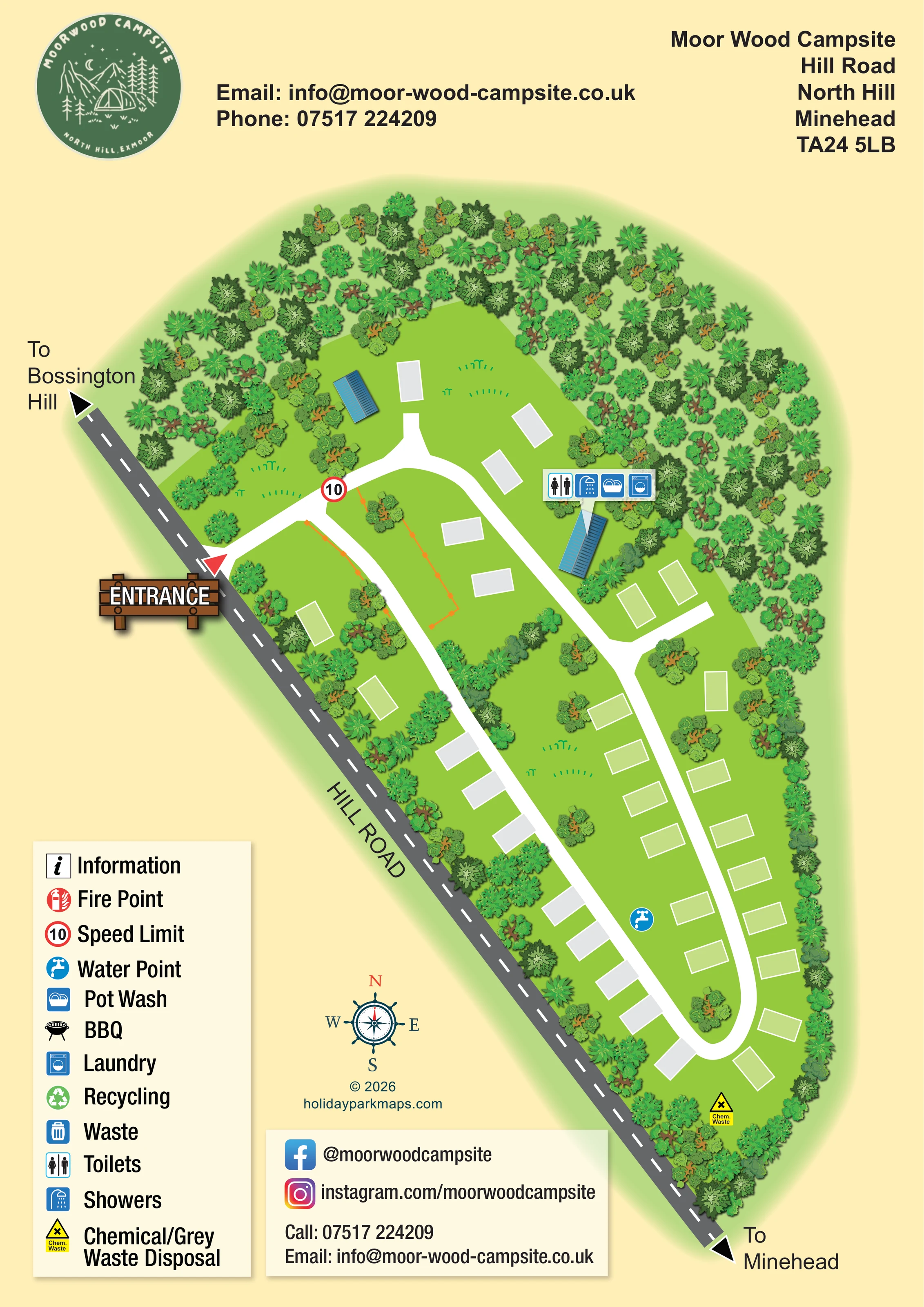
Dense illustrated trees surround the site, especially around the broad northern end, with a narrower wooded strip along the eastern and southern edges.
ILLUSTRATED PARK MAP · P218
Moor Wood Campsite, Hill Road, North Hill, Minehead · United Kingdom
 Enlarge the map ↗
A SENSE OF THE PLACE
Moor Wood Campsite is a small family-run site on North Hill above Minehead, within Exmoor. Tent and campervan pitches sit among countryside with moorland, woodland and coast nearby.
Walking and cycling routes, including access towards the South West Coast Path, are a central attraction. The campsite welcomes families and pets, offering a base for exploring Exmoor, West Somerset and the surrounding coast.
LOOK CLOSER
Dense illustrated trees surround the site, especially around the broad northern end, with a narrower wooded strip along the eastern and southern edges.
Bright green ground, grass tufts and scattered tree and shrub groups separate the pitch rows and frame the lanes.
A red triangular marker and illustrated timber entrance sign identify the access on the western side of the site.
The grey public road runs diagonally along the site's western boundary, with dashed white centre markings.
Black arrowheads at the ends of Hill Road point towards Bossington Hill at the upper left and Minehead at the lower right.
Broad white lanes branch from the entrance, run down both sides of the pitching area and join in a rounded southern loop, with short northern and eastern spurs.
A red-ringed marker displaying 10 appears just inside the entrance; the artwork does not state a unit.
A callout containing toilet and shower symbols points to the blue-roofed service building in the upper-right part of the site.
A red triangular marker and illustrated timber entrance sign identify the access on the western side of the site.
The grey public road runs diagonally along the site's western boundary, with dashed white centre markings.
Black arrowheads at the ends of Hill Road point towards Bossington Hill at the upper left and Minehead at the lower right.
Broad white lanes branch from the entrance, run down both sides of the pitching area and join in a rounded southern loop, with short northern and eastern spurs.
A red-ringed marker displaying 10 appears just inside the entrance; the artwork does not state a unit.
Dense illustrated trees surround the site, especially around the broad northern end, with a narrower wooded strip along the eastern and southern edges.
Bright green ground, grass tufts and scattered tree and shrub groups separate the pitch rows and frame the lanes.
A callout containing toilet and shower symbols points to the blue-roofed service building in the upper-right part of the site.
The pot-wash symbol is included in the service-building callout alongside the sanitary facilities.
A washing-machine symbol in the same callout identifies laundry at the service building.
A blue circular tap symbol marks a water point between the lower pitch rows.
A yellow chemical-waste symbol near the southern end of the loop corresponds to the key's chemical/grey waste disposal entry.
An information symbol is included in the key, but no corresponding position is clearly marked on the plan.
The key includes a red fire-point symbol without a clearly identifiable mapped location.
A barbecue pictogram appears in the key; a barbecue location is not established by the plan.
Separate recycling and waste symbols appear in the key, but their locations are not clearly marked within the site.
READING THE MAP
This illustrated map presents Moor Wood Campsite on North Hill above Minehead, with a compact pitching layout enclosed by a substantial belt of trees. Its portrait composition follows the site's long, tapering shape beside Hill Road, making the relationship between arrival, internal lanes and the wooded boundary easy to understand.
A timber-style entrance sign gives the access point particular prominence. From there, broad white lanes lead through the pitching areas and reconnect in a rounded loop at the southern end. Simple rectangular pitch spaces keep the plan uncluttered, while varied tree canopies and small planting groups convey the campsite's countryside character.
The map shows a service building with a grouped callout for toilets, showers, pot wash and laundry, plus separate water and chemical/grey waste disposal markers farther down the site. Directions towards Bossington Hill and Minehead provide useful local orientation. A circular campsite badge, large facility key and dedicated contact panel complete a design suited to a small campsite that needs practical visitor information without losing its individual woodland setting.
The single portrait map places Moor Wood Campsite within a dense illustrated woodland perimeter. Hill Road runs diagonally down the western edge, with black direction arrows towards Bossington Hill at the upper left and Minehead at the lower right. A red triangle and a large timber entrance sign identify the access, followed by a red-ringed speed marker displaying 10.
Inside the site, white lanes divide into two main branches. One follows the side nearest Hill Road; the other passes the service building and continues beside the eastern pitch rows. They join in a rounded loop near the southern tip. Short spurs extend into the broader northern area and towards pitches near the service building. The unnumbered pitch rectangles use grey and pale-green fills with white edges, although the key does not explain those distinctions.
Two small blue-roofed buildings stand near the northern end. A pointer above the eastern building carries toilet, shower, pot-wash and laundry symbols, making it the principal mapped service hub. A blue tap symbol identifies water between the lower rows, and a yellow chemical-waste marker near the southern loop corresponds to chemical/grey waste disposal in the key. An orange outlined enclosure near the entrance is drawn but not labelled.
The lower-left key includes further symbols for information, fire points, BBQ, recycling and waste, without clearly locating those entries on the plan. Above and below the illustration, the page accommodates the campsite badge, address, contact details and social links. A decorative compass and designer credit sit in the open space beside the diagonal road. The detail views enlarge this same artwork rather than showing additional sections or separate maps.
KEEP EXPLORING
Chosen for shared landscapes, accommodation or facilities.
 Explore the map ↗
United Kingdom
Woodland park map with mixed pitches, bell tents, lodges and a fishing lake.
 Explore the map ↗
United Kingdom
Woodland holiday-park map with named accommodation areas, touring loops and illustrated recreation facilities.
 Explore the map ↗
United Kingdom
Numbered touring pitches, central amenities and wildlife illustrations in a tree-lined countryside site map.
Features may come from the sample artwork, its key or published park information. Approximate numbers describe the drawing and may cover only part of a park. They are intended to help you compare map examples. Current facilities and booking information should be checked with the park.
LET’S MAP YOUR PARK
For a map quotation, find your park and draw a rough boundary around it. The area you select helps us work out the design time and price.
Draw your park for a quote ↗Or talk to our map designers
01751 473136