
Rowan Copse
A named green area occupies the lower western margin of the plan.
ILLUSTRATED PARK MAP · P586
The Old Barn, Ipplepen, Newton Abbot, Devon · United Kingdom
 Enlarge the map ↗
A SENSE OF THE PLACE
Ross Park is based at The Old Barn, Ipplepen, Newton Abbot, Devon. The park has views towards Dartmoor and lies on the edge of the English Riviera. Hardstanding pitches have electricity and water; Premiere pitches also include wastewater connections.
Facilities include a heated amenities block, laundry, dog exercise area and indoor soft play.
LOOK CLOSER
A named green area occupies the lower western margin of the plan.
A named meadow area is shown below Rowan Copse in the western extension.
Dense illustrated trees enclose the northern and western edges; smaller repeated hedge forms divide pitch rows and frame the southern lanes.
An office symbol marks the blue building near the entrance on the right-hand side.
An information symbol appears at the southern end of the narrow eastern facilities building.
The shop is identified within the entrance-side building group.
A wine-glass symbol identifies the restaurant and bar in the large upper-right building.
A prominently labelled section of the large building beside the restaurant and bar.
An office symbol marks the blue building near the entrance on the right-hand side.
An information symbol appears at the southern end of the narrow eastern facilities building.
The shop is identified within the entrance-side building group.
A wine-glass symbol identifies the restaurant and bar in the large upper-right building.
A prominently labelled section of the large building beside the restaurant and bar.
Grouped symbols identify toilets, showers and laundry beside the conservatory, with another toilet block farther north. A wheelchair symbol is also shown at the central amenities block.
Distinct symbols identify these activities in the narrow building along the eastern side of the central facilities area.
A dog-under-shower symbol marks a small service building on the western side of the pitches.
Blue P symbols mark parking beside the eastern facilities and near the entrance.
Yellow circular and triangular lightning symbols distinguish the two electric-point types throughout the pitch groups.
Repeated blue service symbols are distributed along pitch boundaries and beside facilities.
Yellow flask symbols mark disposal facilities beside the central amenities and the western service building.
Bin symbols recur around the internal roads, with recycling marked near the office-side building.
First aid is marked at the office-side building; red fire-point symbols occur around the pitch areas and a green assembly symbol sits beside the eastern facilities.
A telephone symbol appears beside the entrance-side building group.
A rectangular grey court with white line markings is drawn along the western edge. Its sporting use is not named.
A red arrow labelled 'To Play Park' points beyond the western edge of the main pitch plan; the play equipment itself is not depicted.
A named planted corridor crosses the middle of the accommodation layout.
A named green area occupies the lower western margin of the plan.
A named meadow area is shown below Rowan Copse in the western extension.
A red arrow near the southern tip points towards Cherry Orchard, accompanied by a small dog silhouette.
Dense illustrated trees enclose the northern and western edges; smaller repeated hedge forms divide pitch rows and frame the southern lanes.
The entrance is marked at the lower right. Broad grey roads connect the eastern facilities with central loops, perimeter pitches and the tapering southern extension.
READING THE MAP
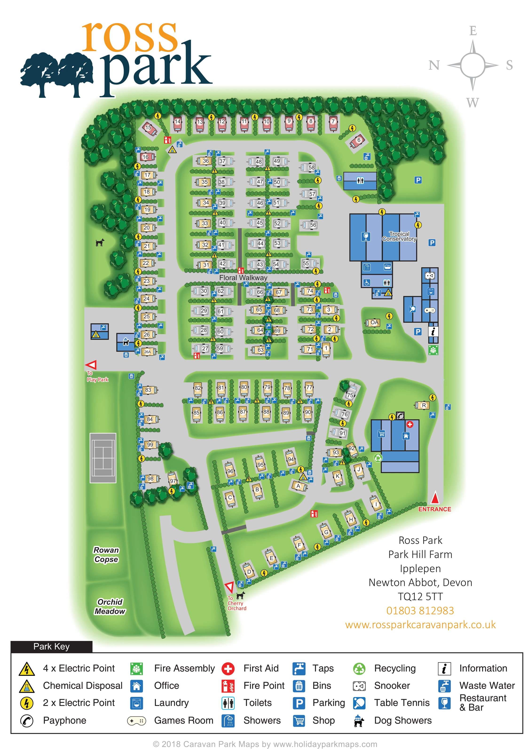
This illustrated map of Ross Park in Ipplepen, near Newton Abbot in Devon, brings a landscaped touring park into a single portrait-format plan. Around 110 individually marked pitches are arranged in hedge-divided rows, perimeter groups and a tapering southern extension. A substantial belt of trees frames the upper and left-hand edges, while Rowan Copse, Orchid Meadow and the Floral Walkway give the layout recognisable landscape landmarks.
The map combines pitch finding with practical visitor information. The entrance, office and shop sit on the right-hand side, with the main amenities and leisure buildings farther along the same route. A labelled Tropical Conservatory is a particularly distinctive feature, alongside symbols for the restaurant and bar, games room, snooker and table tennis. Dog showers and directions towards the play park and Cherry Orchard broaden the picture beyond the pitch rows.
Orange and dark-teal branding, blue facilities and bright service symbols establish a clear visual hierarchy. The generous bottom legend explains the information-rich plan without taking space away from the accommodation layout.
The plan is presented from directly overhead, with east at the top of the compass and north to the left. Arrival is marked by a red entrance arrow at the lower-right edge, close to the office and shop building. From here, the grey road network runs up the eastern side and branches into loops around the central pitch blocks. The southern end narrows into angled rows, including a lettered group, while the northern edge carries a tree-backed line of pitches.
Small caravan illustrations identify the accommodation, with pitch numbers or letters placed inside each unit. Repeated hedge shapes separate neighbouring spaces and make the rows easy to distinguish. Blue tap and wastewater symbols, together with yellow electric-point markers, sit close to many pitch boundaries. The key differentiates two- and four-way electric points and also explains chemical disposal, bins, recycling and safety symbols.
The main visitor facilities form a recognisable cluster on the right. A large blue building contains the restaurant and bar symbol and the labelled Tropical Conservatory. Toilets, showers and laundry are marked immediately below, with another toilet block farther north. A narrow neighbouring building carries symbols for snooker, table tennis, a games room and information. Parking symbols appear beside these facilities and near the office.
The western side includes a dog-shower building and an unlabelled line-marked sports court. A red arrow points towards the play park rather than illustrating it. Farther south, Rowan Copse and Orchid Meadow occupy a green strip beside the extended access lanes, and another arrow indicates Cherry Orchard. The Floral Walkway provides a named central landmark. Large branding, a compass, contact details and a full-width legend complete the single-sheet composition.
KEEP EXPLORING
Chosen for shared landscapes, accommodation or facilities.
 Explore the map ↗
United Kingdom
Illustrated Sanday aire map with a seasonal maze, café barn and motorhome service area.
 Explore the map ↗
United Kingdom
A woodland touring-park map with colour-coded pitches, a stream and footprint-marked walks.
 Explore the map ↗
United Kingdom
Colour-coded campsite map with riverside pitches, bell tents, a swimming pool and fishing lake.
Features may come from the sample artwork, its key or published park information. Approximate numbers describe the drawing and may cover only part of a park. They are intended to help you compare map examples. Current facilities and booking information should be checked with the park.
TAKE A CLOSER LOOK
View the illustrated map in detail or choose a file to download. These are sample maps; contact the park for current visitor information.


LET’S MAP YOUR PARK
For a map quotation, find your park and draw a rough boundary around it. The area you select helps us work out the design time and price.
Draw your park for a quote ↗Or talk to our map designers
01751 473136