
Dog Friendly Beach
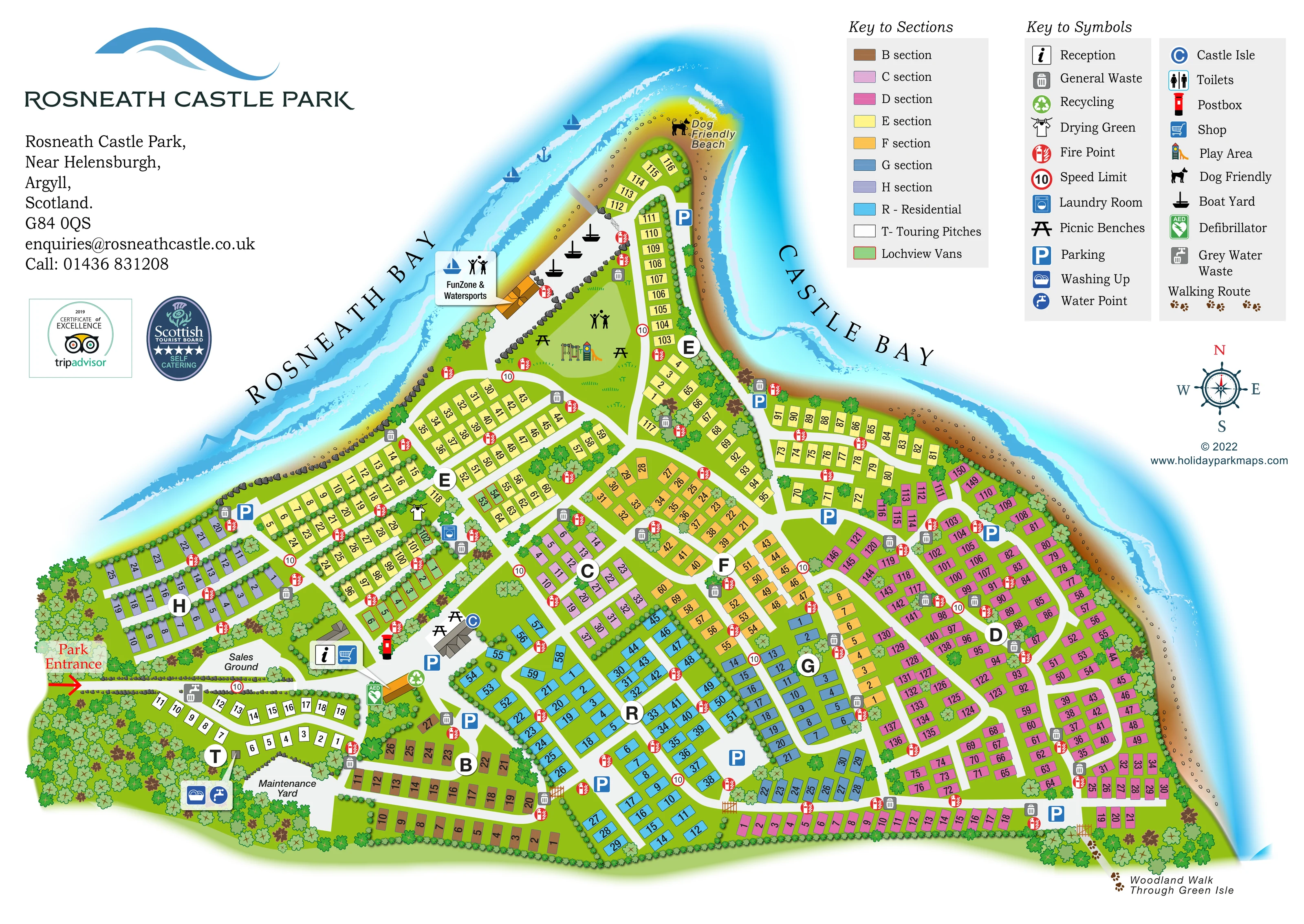
The northern tip is explicitly labelled Dog Friendly Beach and marked with a dog symbol.
ILLUSTRATED PARK MAP · P585
Rosneath, near Helensburgh, Argyll and Bute · United Kingdom
 Enlarge the map ↗
A SENSE OF THE PLACE
Rosneath Castle Park is based at Rosneath, near Helensburgh, Argyll and Bute. The park occupies a peninsula on the Gareloch. Caravan hire, holiday-home ownership and touring stays are offered. The touring area is described as 19 fully serviced hardstanding pitches with private bathrooms.
The park provides a bar and restaurant, shop, launderette and children's play facilities.
LOOK CLOSER
The northern tip is explicitly labelled Dog Friendly Beach and marked with a dog symbol.
Large curved bay labels flank the peninsula, with illustrated water, wave bands, beach and rocky shore edges.
Dense tree belts frame the southern and western edges, while scattered trees divide accommodation rows and recreation spaces.
Reception and shopping symbols identify an arrival-side building beside the sales ground.
A blue C symbol identifies Castle Isle at a substantial building near the central arrival facilities, with nearby picnic benches and parking.
Illustrated swings and a slide occupy an open green towards the northern end of the park.
A labelled waterfront facility sits on the Rosneath Bay side near the boat yard.
Several black boat-yard symbols mark a shore-side working area beside the northern recreation space.
Reception and shopping symbols identify an arrival-side building beside the sales ground.
A blue C symbol identifies Castle Isle at a substantial building near the central arrival facilities, with nearby picnic benches and parking.
Illustrated swings and a slide occupy an open green towards the northern end of the park.
A labelled waterfront facility sits on the Rosneath Bay side near the boat yard.
Several black boat-yard symbols mark a shore-side working area beside the northern recreation space.
Bench symbols appear around the play green and beside Castle Isle.
Laundry and drying-green symbols are grouped among the western-central accommodation rows.
Washing-up and water-point symbols sit beside the touring area; a grey-water waste symbol appears by its entrance-side road.
Toilets are included in the symbol key, but their location is not clearly identifiable in the overview.
General-waste symbols recur throughout the accommodation sections, with a recycling symbol near the central arrival facilities.
Red circular fire-point symbols are distributed along the internal roads and accommodation rows.
A green AED symbol marks a location near the entrance-side facilities and touring area.
A red postbox symbol appears beside the central service cluster.
Blue P symbols identify parking around the facilities, within accommodation sections and near the northern shore.
A red arrow and label identify the entrance at the lower-left edge of the plan.
Circular signs displaying 10 are positioned at intervals along the internal road network.
Small brown pawprint-style marks trace the coastal edge towards the northern beach and eastern woodland connection.
A labelled walking-route connection leaves the lower-right edge through a wooded strip.
The northern tip is explicitly labelled Dog Friendly Beach and marked with a dog symbol.
Large curved bay labels flank the peninsula, with illustrated water, wave bands, beach and rocky shore edges.
Dense tree belts frame the southern and western edges, while scattered trees divide accommodation rows and recreation spaces.
Both operational areas are labelled near the entrance, with the maintenance yard beside the touring section.
Operator information describes a bar and restaurant; the map itself does not explicitly label that function.
READING THE MAP
This illustrated map of Rosneath Castle Park places a large, colour-coded holiday park within its distinctive peninsula setting near Helensburgh in Argyll and Bute. Rosneath Bay and Castle Bay frame the site, with bright blue water, textured shoreline and a dog-friendly beach giving the plan an unmistakably coastal character.
The accommodation is organised into clearly named sections, each with its own colour, large letter marker and individually numbered units. A separate residential area, a compact touring loop and highlighted Lochview Vans add further distinctions without requiring separate plans. White internal roads connect the entrance, reception and shop with the accommodation neighbourhoods and shared facilities.
Beyond locating a holiday home, the map helps visitors understand the wider grounds. It shows the waterfront FunZone and watersports area, boat yard, children's play space, picnic benches and a walking connection through Green Isle. The sample demonstrates how a detailed park plan can combine everyday wayfinding with a recognisable sense of place.
The single-page artwork follows the peninsula from its broad southern base to a narrow northern headland. The park entrance is marked at the lower left, beside the sales ground and a compact touring area. Reception and shop symbols identify an arrival-side building, while Castle Isle, nearby picnic benches, parking and other service symbols form a central facilities cluster. The maintenance yard is labelled separately beside the touring loop.
Accommodation sections spread across a branching network of white roads. Brown, lavender, pink, yellow, orange and blue unit blocks distinguish sections B–H, with cyan used for the residential section and white for touring pitches. Large circular letters make the neighbourhoods easy to recognise at a glance. Individual unit numbers provide finer navigation, while green units edged in red identify Lochview Vans within the wider layout.
The northern part of the plan opens into a recreation green with illustrated play equipment and picnic benches. Along the Rosneath Bay shore, the FunZone and watersports label sits beside a boat-yard area. The headland beyond is marked Dog Friendly Beach. Walking-route marks follow the coastal edge, and a labelled connection at the lower right leads to the Woodland Walk Through Green Isle.
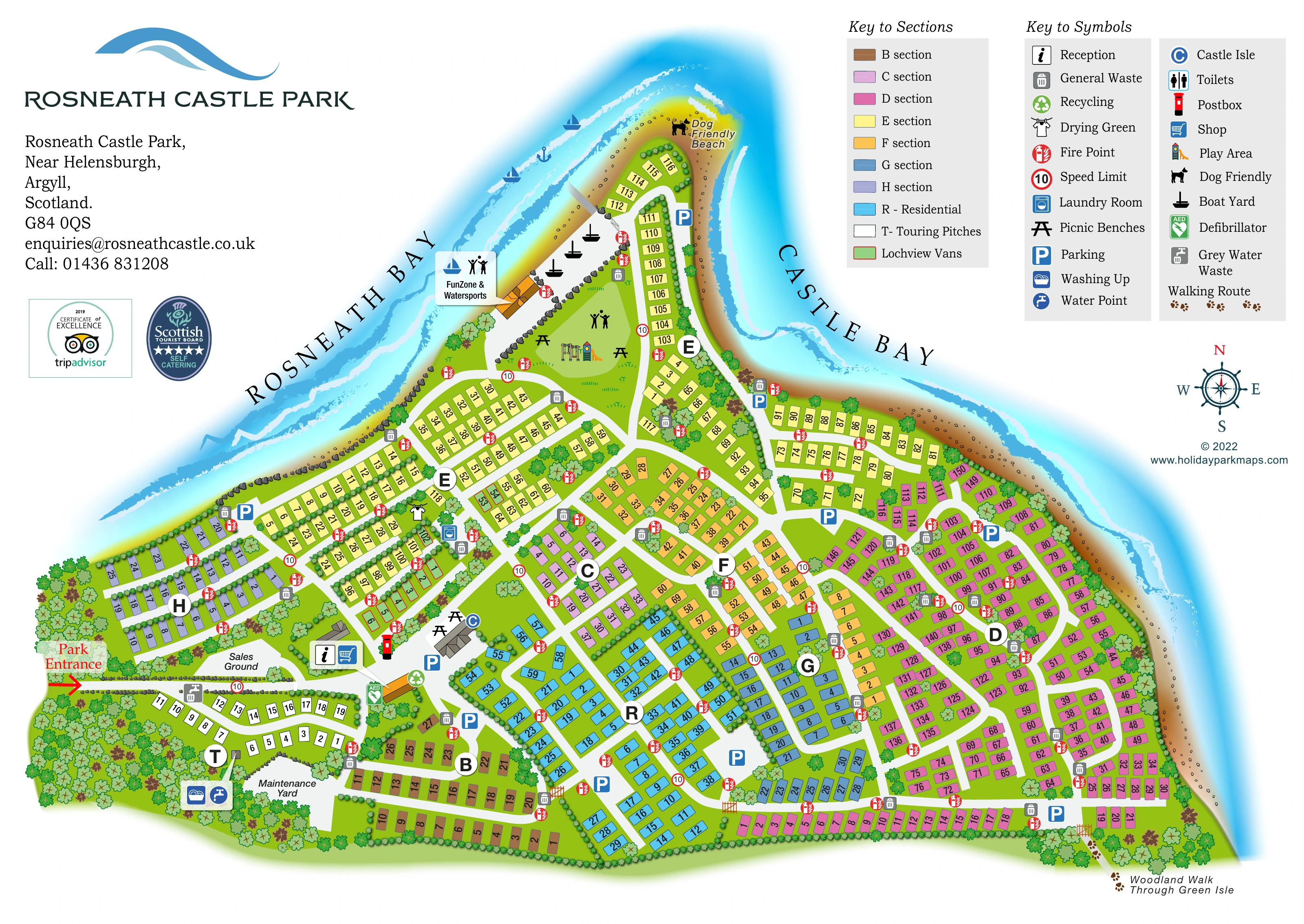
Repeated symbols locate parking, fire points and waste points throughout the park. Laundry, a drying green, recycling, a postbox and a defibrillator add practical detail, with washing-up and water facilities shown beside the touring area. Two upper-right keys explain section colours and facility symbols. The enlarged detail view repeats this same legend and shoreline rather than presenting an additional map or accommodation area.
KEEP EXPLORING
Chosen for shared landscapes, accommodation or facilities.
 Explore the map ↗
United Kingdom
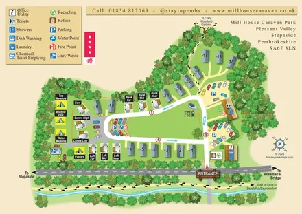
A tree-framed mixed-accommodation park map with a central green, service icons and coastal walking connections.
 Explore the map ↗
United Kingdom
A colour-zoned coastal park map with touring areas, woodland trails, ponds and a leisure club.
 Explore the map ↗
United Kingdom
Colour-coded accommodation, lakeside facilities and woodland routes at Burton Constable Holiday Park & Arboretum.
Features may come from the sample artwork, its key or published park information. Approximate numbers describe the drawing and may cover only part of a park. They are intended to help you compare map examples. Current facilities and booking information should be checked with the park.
TAKE A CLOSER LOOK
View the illustrated map in detail or choose a file to download. These are sample maps; contact the park for current visitor information.


LET’S MAP YOUR PARK
For a map quotation, find your park and draw a rough boundary around it. The area you select helps us work out the design time and price.
Draw your park for a quote ↗Or talk to our map designers
01751 473136
 rosneathparkmapa_large.png