
Sea-view direction
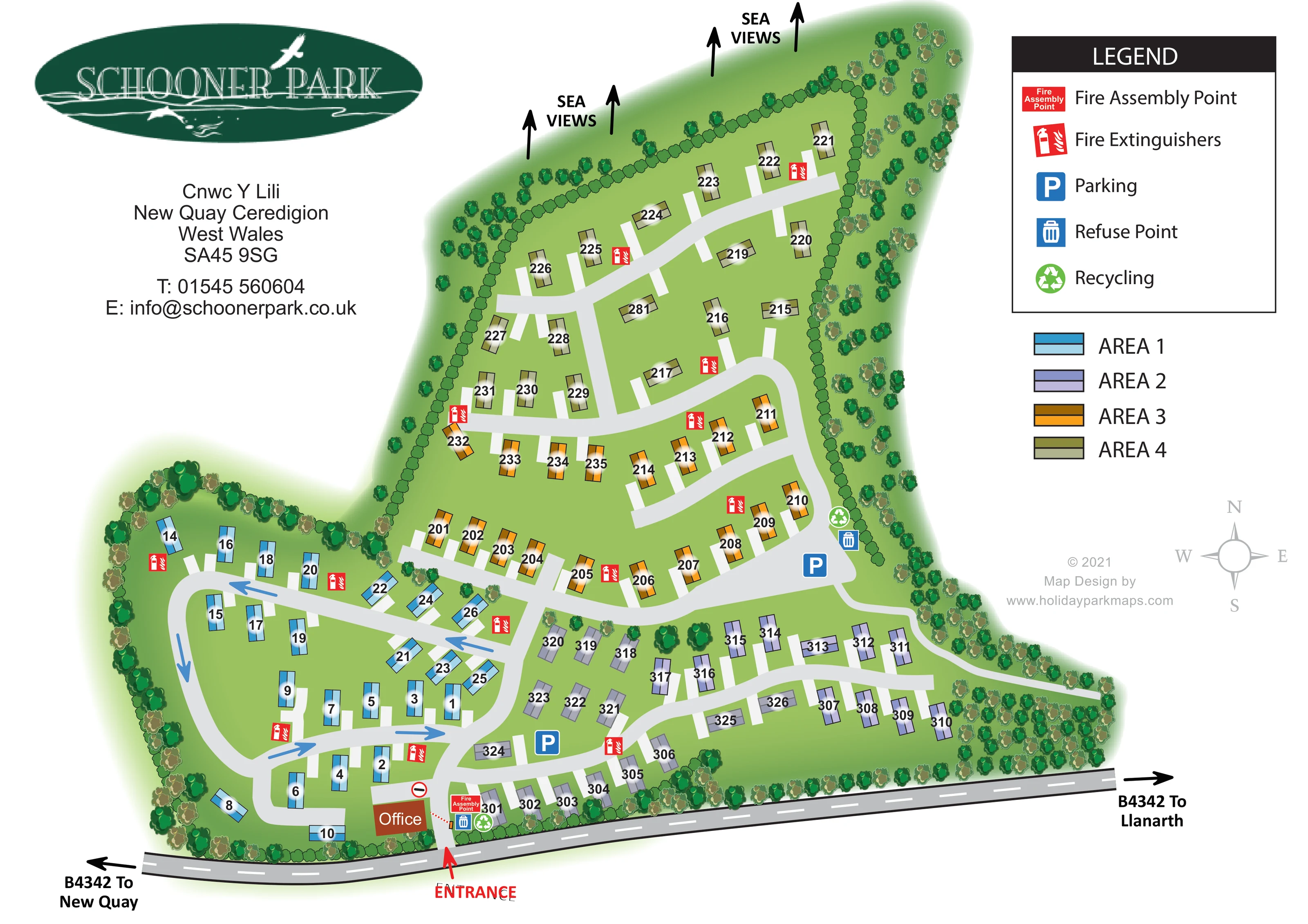
Two SEA VIEWS labels with black arrows point outwards beyond the upper boundary. The sea itself is not drawn.
ILLUSTRATED PARK MAP · P592
Cnwc Y Lili, New Quay, Ceredigion · United Kingdom
 Enlarge the map ↗
A SENSE OF THE PLACE
Schooner Park is based at Cnwc Y Lili, New Quay, Ceredigion. The operator describes its residents as predominantly retired or semi-retired.
Schooner is a residential park with a full residential licence. The estate is in coastal New Quay and includes sea-view plots.
LOOK CLOSER
Two SEA VIEWS labels with black arrows point outwards beyond the upper boundary. The sea itself is not drawn.
Dense stylised trees frame much of the estate, with a continuous scalloped hedge enclosing the upper section and scattered trees between some homes.
A labelled brown office building stands immediately inside the entrance, beside the western residential area.
Blue parking symbols mark two locations: one near the lower central road junction and another at the eastern side of the taller northern section.
Paired refuse and recycling symbols appear near the entrance and beside the parking area on the eastern side.
A red assembly-point marker is shown near the entrance, beside the lower waste and recycling symbols.
Repeated red extinguisher symbols are distributed along the internal roads across the residential areas.
A red arrow and ENTRANCE label identify access from the B4342 at the lower edge of the plan.
A labelled brown office building stands immediately inside the entrance, beside the western residential area.
Blue parking symbols mark two locations: one near the lower central road junction and another at the eastern side of the taller northern section.
Paired refuse and recycling symbols appear near the entrance and beside the parking area on the eastern side.
A red assembly-point marker is shown near the entrance, beside the lower waste and recycling symbols.
Repeated red extinguisher symbols are distributed along the internal roads across the residential areas.
A red arrow and ENTRANCE label identify access from the B4342 at the lower edge of the plan.
The frontage road is labelled towards New Quay to the left and Llanarth to the right.
Pale-grey roads form a western loop and branching routes through the northern and eastern sections. Blue arrows indicate the direction of circulation on the western loop; a no-entry symbol is shown near the office.
Home symbols identify Area 1 in blue, Area 2 in lavender, Area 3 in orange and Area 4 in olive, explained by swatches beneath the facility legend.
Two SEA VIEWS labels with black arrows point outwards beyond the upper boundary. The sea itself is not drawn.
Dense stylised trees frame much of the estate, with a continuous scalloped hedge enclosing the upper section and scattered trees between some homes.
Operator information identifies Schooner as a fully licensed residential park whose residents are predominantly retired or semi-retired.
READING THE MAP
This map of Schooner Park in New Quay, Ceredigion, presents a coastal residential estate as a clear, colour-coded site plan. Approximately 85 home plots are arranged across four areas, with blue, lavender, orange and olive roof symbols helping readers recognise each section at a glance. The estate’s irregular shape is easy to follow: a looping road serves the western homes, an eastern branch runs along the lower frontage, and a taller section extends towards the sea-view side of the park.
The design combines everyday navigation with a restrained landscape illustration. Numbered homes, the entrance, office, parking and waste points remain prominent, while repeated trees and hedge lines give the plan its green, enclosed character. Arrows towards New Quay and Llanarth connect the internal layout to the B4342, and separate sea-view arrows describe the outlook beyond the upper boundary.
An oval coastal logo, generous white margins and a clearly separated legend complete a sample suited to residential estates that need recognisable branding and practical plot-level wayfinding on a single page.
The plan places the B4342 along its lower edge, with New Quay indicated to the left and Llanarth to the right. A red entrance arrow leads into the estate beside the labelled office. Nearby symbols identify the fire assembly point, refuse and recycling, establishing a useful cluster of arrival landmarks without adding a separate entrance inset.
Inside the boundary, pale-grey roads organise four groups of numbered homes. Area 1 uses blue roof symbols around the western loop, where blue arrows indicate circulation. Area 2 uses lavender symbols across the lower and eastern section, with homes arranged on both sides of a gently curving branch road. Orange Area 3 occupies the middle of the northern extension, while olive Area 4 continues towards its upper end. Short white strips link the homes to the roads, and white highlights keep their black numbers legible against the coloured roofs.
Parking symbols appear near the lower central junction and on the eastern side of the northern section. Refuse and recycling are also marked at the latter location, while red extinguisher symbols recur beside roads throughout the estate. A no-entry symbol appears close to the office.
Trees frame the irregular perimeter, and a scalloped hedge line encloses much of the upper section. Black sea-view arrows point beyond this boundary; no coastline or water surface is illustrated. The upper-right legend explains the facility symbols, with a separate four-colour area key below it. A compass and small designer credit sit in the remaining white space. The accompanying enlarged detail shows the same legend and adjacent homes, rather than a separate map variant.
KEEP EXPLORING
Chosen for shared landscapes, accommodation or facilities.
 Explore the map ↗
United Kingdom
Illustrated Sanday aire map with a seasonal maze, café barn and motorhome service area.
 Explore the map ↗
United Kingdom
Illustrated coastal campsite plan with named fields, electric pitch colours, beach routes and the Afon Hen.
 Explore the map ↗
United Kingdom
Coastal park map with static-caravan rows, touring pitches, a camping field and two leisure clusters.
Features may come from the sample artwork, its key or published park information. Approximate numbers describe the drawing and may cover only part of a park. They are intended to help you compare map examples. Current facilities and booking information should be checked with the park.
TAKE A CLOSER LOOK
View the illustrated map in detail or choose a file to download. These are sample maps; contact the park for current visitor information.


LET’S MAP YOUR PARK
For a map quotation, find your park and draw a rough boundary around it. The area you select helps us work out the design time and price.
Draw your park for a quote ↗Or talk to our map designers
01751 473136