
Tree-lined boundaries and planted divisions
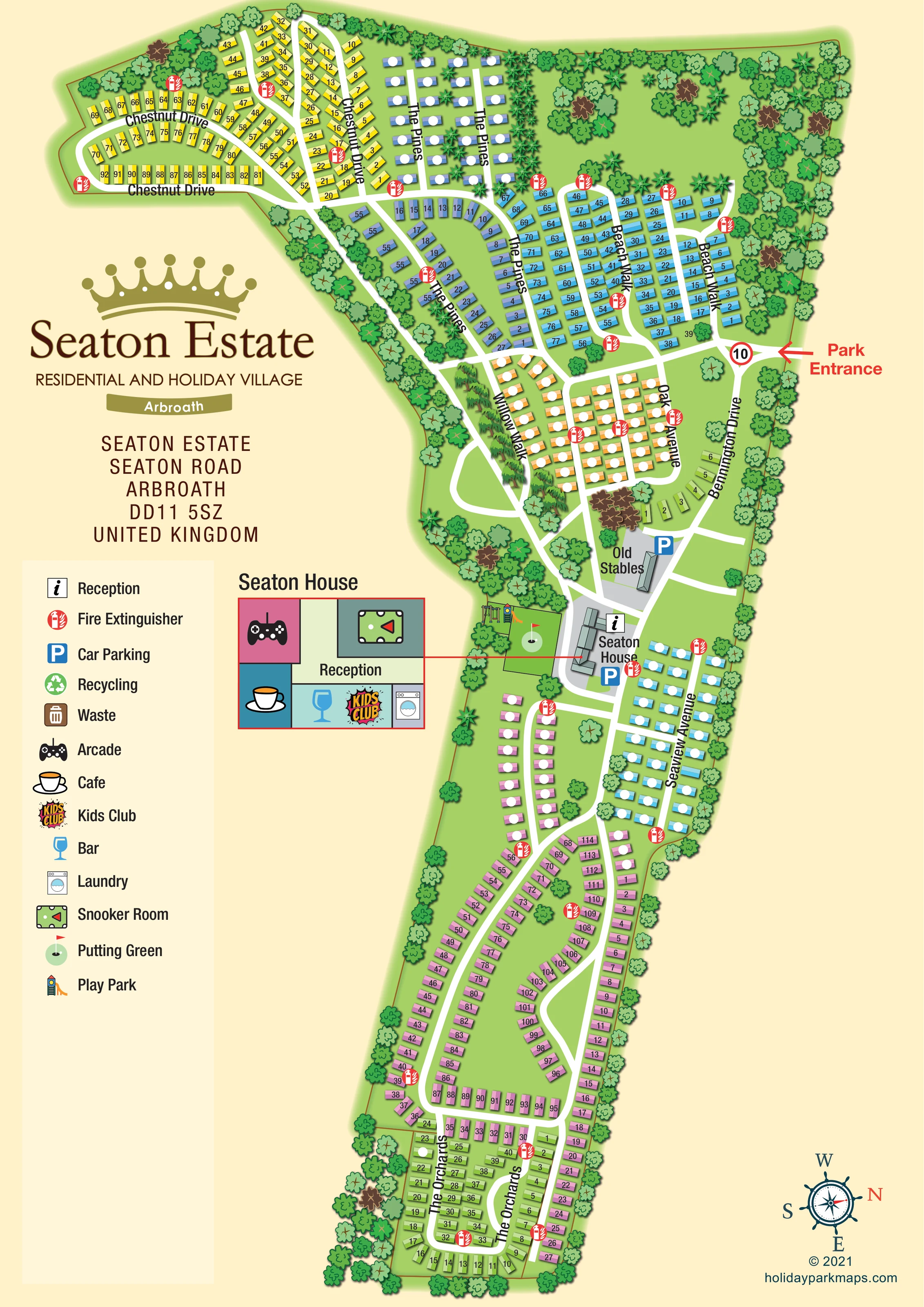
Dense illustrated trees frame the estate boundary, separate some neighbourhoods and surround a broad open green area at the upper right.
ILLUSTRATED PARK MAP · P594
Seaton Road, Arbroath, Angus · United Kingdom
 Enlarge the map ↗
A SENSE OF THE PLACE
Seaton Estate Holiday Village is based at Seaton Road, Arbroath, Angus. Seaton Estate provides holiday-home ownership and holiday rentals. The rental fleet includes lodges and holiday homes, with pet-friendly choices.
The map brings the site layout and its access routes together in one view, providing a reference for understanding the arrangement of the grounds.
LOOK CLOSER
Dense illustrated trees frame the estate boundary, separate some neighbourhoods and surround a broad open green area at the upper right.
A substantial grass-coloured area with scattered tree clusters occupies the upper-right portion of the plan.
An information symbol marks Seaton House, and the linked building inset explicitly labels reception.
Named central building with a red-linked inset showing its reception and leisure facilities.
A separate named building immediately above Seaton House on the page; its current function is not specified.
Blue parking symbols identify parking beside Seaton House and the Old Stables.
A games-controller symbol places the arcade within the Seaton House inset.
A cup symbol identifies the café within the Seaton House inset.
An information symbol marks Seaton House, and the linked building inset explicitly labels reception.
Named central building with a red-linked inset showing its reception and leisure facilities.
A separate named building immediately above Seaton House on the page; its current function is not specified.
Blue parking symbols identify parking beside Seaton House and the Old Stables.
A games-controller symbol places the arcade within the Seaton House inset.
A cup symbol identifies the café within the Seaton House inset.
A colourful Kids Club emblem appears in the lower part of the Seaton House inset.
A stemmed-glass symbol identifies the bar within the Seaton House inset.
A washing-machine symbol places the laundry in the Seaton House inset.
A table-and-balls symbol identifies the snooker room within the Seaton House inset.
A flag-and-hole symbol marks a green recreation area beside Seaton House.
Illustrated swings and a slide stand beside the putting green near Seaton House.
Repeated red circular extinguisher symbols are distributed throughout the accommodation neighbourhoods and central buildings.
A recycling symbol is defined in the key; no corresponding location is clearly established on the plan.
A waste-bin symbol is defined in the key; no corresponding location is clearly established on the plan.
Dense illustrated trees frame the estate boundary, separate some neighbourhoods and surround a broad open green area at the upper right.
A substantial grass-coloured area with scattered tree clusters occupies the upper-right portion of the plan.
A large red arrow marks the entrance on the right-hand boundary, at the junction serving Beach Walk and Bennington Drive.
Chestnut Drive, The Pines, Beach Walk, Willow Walk, Oak Avenue, Bennington Drive, Seaview Avenue and The Orchards label the connected internal routes.
A red-bordered roundel displaying 10 appears just inside the entrance; no unit is stated.
READING THE MAP
This illustrated map of Seaton Estate in Arbroath, Angus, brings a large residential and holiday village into a single portrait-format plan. Its distinctive shape is central to the design: a broad upper section narrows into a long stretch of accommodation, with Seaton House and the Old Stables forming a recognisable hub between the two. Coloured holiday-home symbols, named roads and a strong entrance marker help readers make sense of the many connected neighbourhoods.
The map shows tree-lined boundaries, planted divisions and open green space alongside the accommodation. Around Seaton House, parking, a play park and a putting green establish useful landmarks. A linked inset gives the building's reception and leisure facilities more room than they could occupy on the main plan, identifying the café, bar, arcade, Kids Club, laundry and snooker room.
Large Seaton Estate branding fills the space to the left of the grounds, above a practical facility key. The result is a sample suited to a sizeable holiday-home estate where visitors need both an overview of the neighbourhoods and a clear introduction to the central facilities.
The plan is drawn from above, with white roads laid across light-green grounds and accommodation represented by small, shaded roof forms. The upper-left Chestnut Drive neighbourhood uses yellow units around branching roads and a broad loop. Blue units define The Pines, while cyan rows occupy Beach Walk beneath a substantial open green area. Orange accommodation along Willow Walk and Oak Avenue sits closer to the middle of the estate, with a short green group beside Bennington Drive.
A red arrow marks the park entrance on the right-hand edge, beside a red-bordered 10 roundel. From this junction, the road network links the upper neighbourhoods with the Old Stables and Seaton House. Both buildings have parking symbols, and Seaton House carries the reception marker. Immediately alongside it, illustrated play equipment and a flag-and-hole symbol identify the play park and putting green.
The lower portion stretches down the page through cyan accommodation on Seaview Avenue and a larger pink neighbourhood arranged around curved roads and long rows. Green units around The Orchards complete the lower end. Tree belts trace much of the boundary, with additional planting between roads and accommodation groups. Many units display numbers, although the map does not explain the neighbourhood colours as accommodation categories.
A red leader line connects Seaton House to a separate schematic inset showing reception, arcade, café, bar, Kids Club, laundry and snooker room. The tall left-hand legend explains these icons alongside parking, extinguisher, recycling and waste symbols; red extinguisher markers recur across the grounds. A nautical compass indicates north to the right. The artwork is a single page, with the building inset supplementing rather than duplicating the estate plan.
KEEP EXPLORING
Chosen for shared landscapes, accommodation or facilities.
 Explore the map ↗
United Kingdom
A wooded Allerton park plan with colour-coded neighbourhoods, touring pitches and a central facilities hub.
 Explore the map ↗
United Kingdom
Illustrated coastal holiday-home plan with dense alphanumeric plot labels, orange-roofed amenities, a numbered facility key and beach-side context.
 Explore the map ↗
United Kingdom
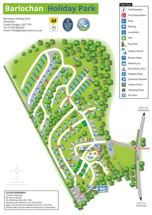
A wooded, mixed-accommodation park plan with winding lanes, a pool, camping areas and a clear facility key.
Features may come from the sample artwork, its key or published park information. Approximate numbers describe the drawing and may cover only part of a park. They are intended to help you compare map examples. Current facilities and booking information should be checked with the park.
TAKE A CLOSER LOOK
View the illustrated map in detail or choose a file to download. These are sample maps; contact the park for current visitor information.

LET’S MAP YOUR PARK
For a map quotation, find your park and draw a rough boundary around it. The area you select helps us work out the design time and price.
Draw your park for a quote ↗Or talk to our map designers
01751 473136
