
Leeds–Liverpool Canal
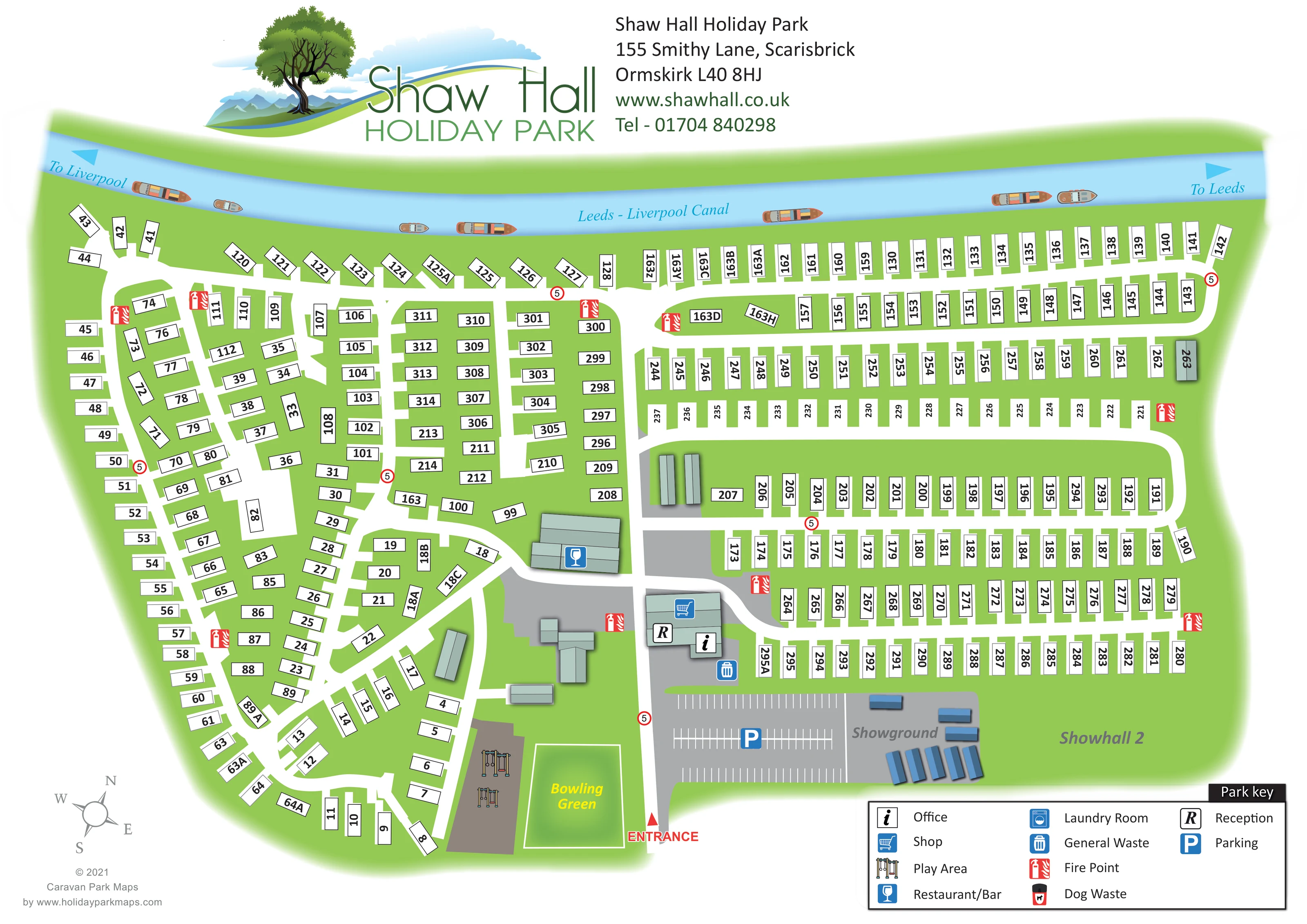
A broad blue canal forms the upper boundary of the plan, illustrated with narrowboats and directional arrows towards Liverpool and Leeds.
ILLUSTRATED PARK MAP · P294
155 Smithy Lane, Scarisbrick, Ormskirk · United Kingdom
 Enlarge the map ↗
A SENSE OF THE PLACE
Shaw Hall Holiday Park is based at 155 Smithy Lane, Scarisbrick, Ormskirk. Shaw Hall is beside the Leeds–Liverpool Canal at Scarisbrick. The park offers static holiday homes for ownership.
The park provides a restaurant and bar, shop, laundry and children's play areas.
LOOK CLOSER
A broad blue canal forms the upper boundary of the plan, illustrated with narrowboats and directional arrows towards Liverpool and Leeds.
A red arrow and ENTRANCE label identify the approach at the lower edge beside the bowling green and parking area.
A central approach branches into winding western lanes and elongated eastern loops. Small red-ringed signs marked 5 recur beside the routes.
Separate R and information symbols mark reception and office functions on the central building near the entrance route.
A blue shopping-trolley symbol marks the shop in the central reception and office building.
A blue wine-glass symbol identifies a separate building on the western side of the central arrival area.
A broad grey parking area with white bay markings and a blue P sits just inside the entrance, alongside the showground.
Illustrated play equipment occupies a brown rectangular area near the lower edge, beside the bowling green.
A broad blue canal forms the upper boundary of the plan, illustrated with narrowboats and directional arrows towards Liverpool and Leeds.
A red arrow and ENTRANCE label identify the approach at the lower edge beside the bowling green and parking area.
A central approach branches into winding western lanes and elongated eastern loops. Small red-ringed signs marked 5 recur beside the routes.
Separate R and information symbols mark reception and office functions on the central building near the entrance route.
A blue shopping-trolley symbol marks the shop in the central reception and office building.
A blue wine-glass symbol identifies a separate building on the western side of the central arrival area.
A broad grey parking area with white bay markings and a blue P sits just inside the entrance, alongside the showground.
Illustrated play equipment occupies a brown rectangular area near the lower edge, beside the bowling green.
A clearly outlined green rectangle with a yellow label lies immediately west of the entrance.
A labelled display area beside the car park contains blue illustrated caravan-like units, distinct from the numbered accommodation.
The artwork labels an open green area to the right of the showground as Showhall 2, without defining its use further.
Repeated red extinguisher symbols identify fire points throughout the accommodation areas and around the central facilities.
A blue bin symbol marks a general-waste point near the central reception and shop building.
The key includes a blue washing-machine symbol for a laundry room; its location is not clearly identifiable on the main plan.
A dog-waste bin appears in the key, but no corresponding position is clearly identifiable on the main plan.
READING THE MAP
The Leeds–Liverpool Canal gives this Shaw Hall Holiday Park map its most recognisable feature. Running across the full width of the illustration, the blue waterway, small narrowboats and arrows towards Leeds and Liverpool establish the park's canal-side setting in Scarisbrick, near Ormskirk. Below it, a substantial static holiday-home layout is presented through clear numbered rectangles and a connected network of white roads.
The design brings together two different patterns of development: winding lanes and angled plots on the left, and long, orderly rows on the right. Shared facilities form a central hub reached from the entrance at the bottom of the page. Reception, office, shop and restaurant/bar symbols help visitors identify the principal buildings, while the nearby parking area, showground, play area and bowling green make the arrival zone easy to recognise.
A large branded header and a compact lower-right key complete the page. This sample is useful for parks needing a legible overview of numerous holiday-home positions while retaining distinctive landscape features and clearly separating accommodation, facilities and display areas.
The plan is organised around a canal frontage at the top and an entrance at the lower edge. The arrival road runs between the bowling green and the parking/showground area, then passes the central facilities before connecting with both halves of the accommodation layout. Reception and office symbols share a building with the shop marker on the right of this route. A separate restaurant/bar building sits to the left, and a general-waste symbol appears near the central service area.
On the western side, roads curve around the perimeter and branch between loosely grouped holiday-home positions. The numbered white rectangles turn with the lanes, making the irregular geometry easy to follow. The eastern side is more regimented, with several long rows served by broad connecting roads and rounded end turns. Accommodation also follows the canal edge, creating a continuous upper band across the plan.
Near the entrance, white bay markings identify the sizeable parking area. Blue shaded display units distinguish the adjacent Showground, while the open green space beyond carries the label Showhall 2. On the opposite side of the approach, a brown play area contains illustrated equipment and sits beside the outlined bowling green. Red fire-point symbols are distributed through the park. The key also lists laundry and dog-waste symbols, although their positions are not clearly resolved in the main drawing.
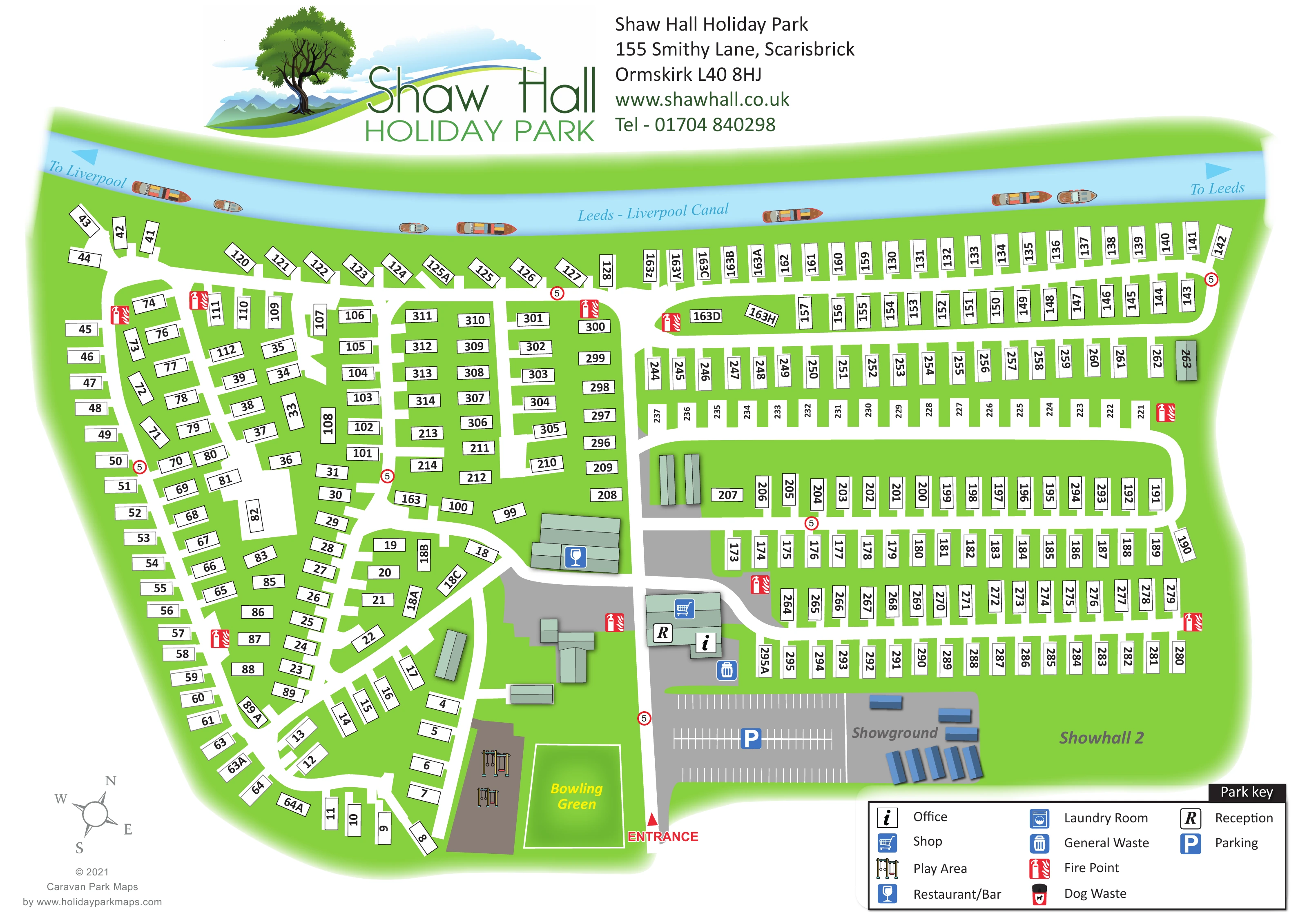
The presentation combines an overhead road-and-plot diagram with lightly dimensional facility roofs, display units and narrowboats. A grey compass, blue canal labels, red entrance arrow and boxed facility key support orientation without requiring named internal roads. The accompanying lower-edge enlargements show the same artwork's compass, entrance and key in greater detail; they are not separate park sections.
KEEP EXPLORING
Chosen for shared landscapes, accommodation or facilities.
 Explore the map ↗
United Kingdom
Coastal park map with static-caravan rows, touring pitches, a camping field and two leisure clusters.
 Explore the map ↗
United Kingdom
A wooded Allerton park plan with colour-coded neighbourhoods, touring pitches and a central facilities hub.
 Explore the map ↗
United Kingdom
Illustrated coastal holiday-home plan with dense alphanumeric plot labels, orange-roofed amenities, a numbered facility key and beach-side context.
Features may come from the sample artwork, its key or published park information. Approximate numbers describe the drawing and may cover only part of a park. They are intended to help you compare map examples. Current facilities and booking information should be checked with the park.
TAKE A CLOSER LOOK
View the illustrated map in detail or choose a file to download. These are sample maps; contact the park for current visitor information.


LET’S MAP YOUR PARK
For a map quotation, find your park and draw a rough boundary around it. The area you select helps us work out the design time and price.
Draw your park for a quote ↗Or talk to our map designers
01751 473136
 shawhall_large.png