
Coastline, beaches, coves and rock pools
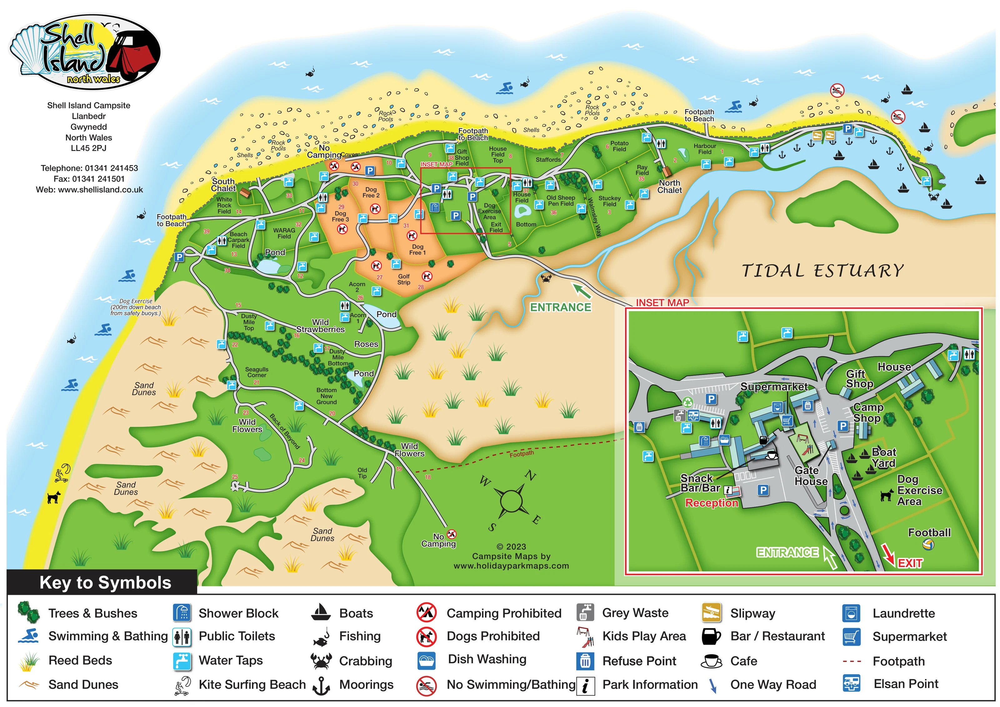
A long sandy coastal edge includes labelled rock pools, shells and coves, with several footpaths leading to the beach.
ILLUSTRATED PARK MAP · P295
Shell Island, Llanbedr, Gwynedd · United Kingdom
 Enlarge the map ↗
A SENSE OF THE PLACE
Shell Island Campsite is based at Shell Island, Llanbedr, Gwynedd. Camping, campervans and motorhomes are accepted; touring caravans are not. The operator states that there are no electric hook-ups.
The park provides shops, food outlets, a bar and games room.
LOOK CLOSER
A long sandy coastal edge includes labelled rock pools, shells and coves, with several footpaths leading to the beach.
A broad tan estuary occupies the right-hand side of the plan, crossed by branching blue tidal channels beside the approach road.
Large dune areas wrap around the western and southern camping fields, illustrated with sandy ground, orange dune marks and grass tufts.
Several pale-blue ponds appear among the camping areas. Reed-bed illustrations punctuate the sandy estuary margins and dune landscape.
Tree and bush clusters accompany labels for wild strawberries, roses and wild flowers, especially around the southern fields.
Reception is prominently labelled in red within the enlarged central facilities inset, beside the park-information symbol.
Three separately named shopping facilities surround the central roads and parking areas in the inset.
The inset labels a Snack Bar/Bar and places café and bar/restaurant symbols around the reception-side buildings.
Reception is prominently labelled in red within the enlarged central facilities inset, beside the park-information symbol.
Three separately named shopping facilities surround the central roads and parking areas in the inset.
The inset labels a Snack Bar/Bar and places café and bar/restaurant symbols around the reception-side buildings.
Shower and dish-washing symbols identify facilities around the central hub; toilet symbols also appear at several locations across the main plan.
Cyan tap symbols are distributed throughout the camping fields and around the facilities complex.
A washing-machine symbol marks the laundrette within the central building group.
The inset groups refuse, recycling, grey-waste and Elsan symbols around the service area west of the supermarket.
Illustrated play equipment sits within the central complex, while a football symbol and label mark a green area beside the entrance and exit.
A dog exercise area is labelled beside the boat yard and football area. A separate beach annotation identifies another dog exercise location.
Blue parking symbols identify spaces at the main complex, near the harbour and in western areas including Beach Carpark Field.
The eastern harbour contains boats and anchor symbols, with slipway symbols on its shore. A boat yard is separately labelled in the central inset.
A long sandy coastal edge includes labelled rock pools, shells and coves, with several footpaths leading to the beach.
A broad tan estuary occupies the right-hand side of the plan, crossed by branching blue tidal channels beside the approach road.
Large dune areas wrap around the western and southern camping fields, illustrated with sandy ground, orange dune marks and grass tufts.
Several pale-blue ponds appear among the camping areas. Reed-bed illustrations punctuate the sandy estuary margins and dune landscape.
Tree and bush clusters accompany labels for wild strawberries, roses and wild flowers, especially around the southern fields.
Blue swimmer symbols appear along the outer coast. Separate red prohibition symbols mark no-swimming/bathing locations near the harbour approach.
Fishing symbols occur along the coast and around the harbour; crabbing symbols appear beside the estuary-side road and harbour edge.
The kite-surfing symbol is positioned on the western beach.
The approach crosses the estuary margin into the central hub. The inset separates entrance and exit arrows and labels the gate house.
Grey roads branch through the camping fields, with loops and short spurs. Blue arrows show one-way movement around the central facilities.
Several coastal exits are labelled Footpath to Beach. A red dashed footpath crosses the lower inland portion of the plan, and Walmsley Way is named beside eastern fields.
Red prohibition symbols identify no-camping areas and dog restrictions. The central dog-free fields use a contrasting warm orange fill.
Named buildings provide landmarks on the coastal road and within the facilities inset; the artwork does not establish their accommodation use.
Operator information mentions a games room, but it is not separately identified on this map.
READING THE MAP
This illustrated map of Shell Island Campsite in Llanbedr, Gwynedd, puts the coastal landscape at the centre of the visitor experience. Beaches and rock pools curve around the upper and western edges, while broad sand dunes and a tidal estuary frame the camping fields inland. Rather than drawing individual pitches, the plan uses named and numbered areas to explain how this open campsite is organised.
Grey roads connect the fields to a central reception and shopping complex, with water taps and toilets marked across the site. A large inset gives the busiest part of the map more room, showing the supermarket, camp shop, gift shop, snack bar/bar, parking and gate house alongside entrance and exit arrows. Harbour facilities and beach activities add another layer of practical information.
The result is a useful example for campsites where visitors need to understand fields, shared services and access to the surrounding landscape. Its combination of a broad site overview and a detailed arrival inset avoids forcing every building and symbol into the same scale.
The main plan follows Shell Island's curved coastline, placing sandy beaches and rock pools above the northern camping fields and extending the dune landscape down the left-hand side. On the right, a labelled tidal estuary is drawn with branching blue channels. The approach road crosses this margin before reaching the central facilities, then divides into routes serving the coastal fields and the more widely spread southern areas.
Camping areas are identified through field names and red numbers, not individual pitch outlines. Several central dog-free areas stand out in orange against the green ground. Elsewhere, ponds, tree belts and labels for wild strawberries, roses and wild flowers help distinguish parts of the site. No-camping symbols appear at selected locations, while beach-access labels and a red dashed footpath explain pedestrian connections.
The harbour end includes boats, moorings, slipways and parking. Along the outer shore, pictograms identify swimming, fishing and kite surfing; crabbing symbols appear around the estuary and harbour. Water taps and toilets are distributed through the field network.
A red locator box connects the overview to the enlarged facilities inset at lower right. This shows reception, the supermarket, camp and gift shops, snack bar/bar, café symbols, the laundrette, showers and dish washing. Waste-service symbols, parking bays, play equipment, a boat yard, dog exercise area and football area complete the close-up. Directional arrows distinguish entrance, exit and one-way movement around the gate house.
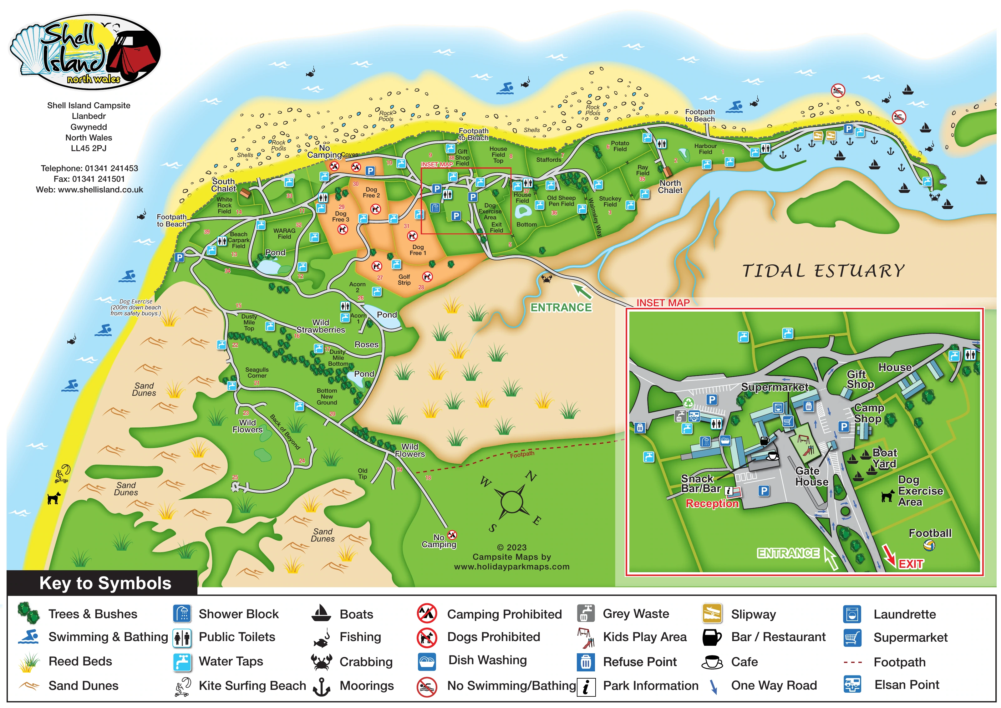
A full-width symbol key anchors the page beneath the artwork. The two accompanying legend enlargements are close-ups of that same key, not additional map variants or camping areas.
KEEP EXPLORING
Chosen for shared landscapes, accommodation or facilities.
 Explore the map ↗
United Kingdom
Colour-coded accommodation, central leisure facilities and coastal paths on an illustrated headland park map.
 Explore the map ↗
United Kingdom
Trevornick’s colour-coded park map, with mixed accommodation, fishing ponds, golf and wooded trails.
 Explore the map ↗
United Kingdom
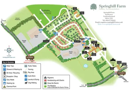
Mixed-accommodation farm map with separate entrances, touring loops, wigwams, cottages and an open camping meadow.
Features may come from the sample artwork, its key or published park information. Approximate numbers describe the drawing and may cover only part of a park. They are intended to help you compare map examples. Current facilities and booking information should be checked with the park.
TAKE A CLOSER LOOK
View the illustrated map in detail or choose a file to download. These are sample maps; contact the park for current visitor information.


LET’S MAP YOUR PARK
For a map quotation, find your park and draw a rough boundary around it. The area you select helps us work out the design time and price.
Draw your park for a quote ↗Or talk to our map designers
01751 473136
 shellislandmap_large.png