
Delta Area
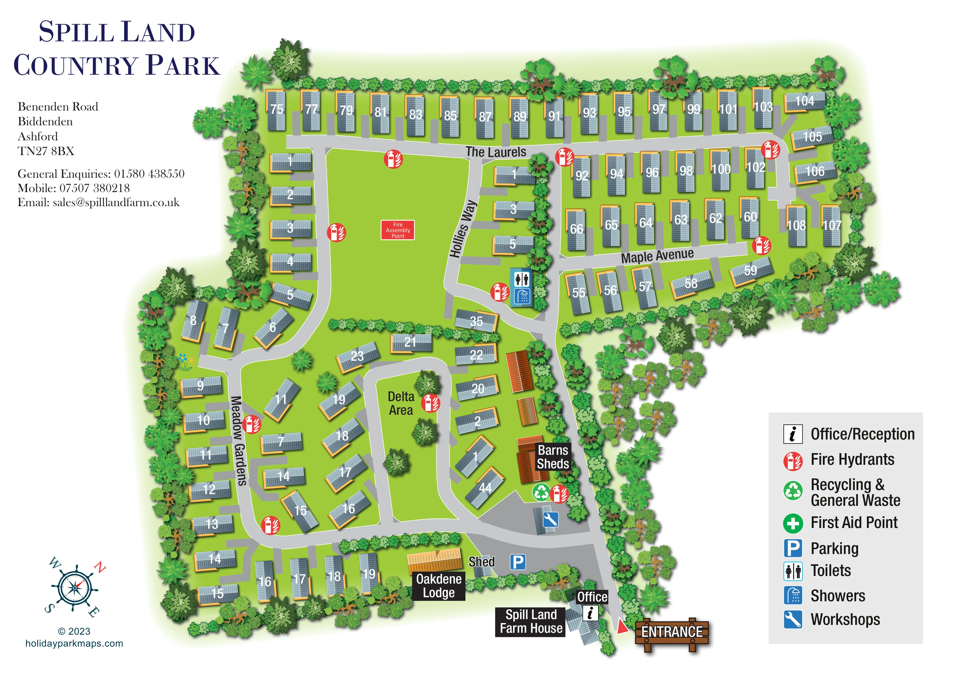
A long planted green island inside the lower inner loop is labelled Delta Area.
ILLUSTRATED PARK MAP · P309
Benenden Road, Biddenden, Ashford, Kent · United Kingdom
 Enlarge the map ↗
A SENSE OF THE PLACE
Spill Land Country Park is based at Benenden Road, Biddenden, Ashford, Kent. The park markets park homes to an over-45 community.
Published features include pet-friendly grounds, private parking and on-site maintenance. The site is south of Biddenden among woodland and agricultural land in the Weald of Kent.
LOOK CLOSER
A long planted green island inside the lower inner loop is labelled Delta Area.
A substantial unbuilt green space separates the upper streets from the lower residential groups and contains the assembly-point label.
Dense illustrated trees frame much of the perimeter and entrance road, while clipped-looking hedge rows divide residential groups and green spaces.
A timber-style ENTRANCE sign and red pointer identify the access at the lower-right edge, beside the office and farmhouse.
The Office label and information symbol mark the arrival-side building beside Spill Land Farm House.
A blue P marks the broad grey arrival-side area near Oakdene Lodge and the shed.
Paired toilet and shower symbols locate a block beside Hollies Way, close to its connection with the main internal spine.
A green recycling symbol marks the service area beside the barns and sheds.
A timber-style ENTRANCE sign and red pointer identify the access at the lower-right edge, beside the office and farmhouse.
The Office label and information symbol mark the arrival-side building beside Spill Land Farm House.
A blue P marks the broad grey arrival-side area near Oakdene Lodge and the shed.
Paired toilet and shower symbols locate a block beside Hollies Way, close to its connection with the main internal spine.
A green recycling symbol marks the service area beside the barns and sheds.
A blue spanner symbol identifies a small building in the grey service yard above the parking area.
Repeated red circular symbols mark fire hydrants along the named roads, lower loops and service area.
A red rectangular label identifies the fire assembly point within the large central lawn.
A green cross appears in the legend, but no corresponding location is clearly visible on the plan.
A named grey-roofed building cluster sits beside the office at the entrance end of the park; its use beyond the label is not specified.
A separately named ochre-roofed building lies beside the lower parking area. The label alone does not establish visitor accommodation.
Orange-roofed barns and sheds line the service side of the lower residential area, with another shed labelled near Oakdene Lodge.
The Laurels and Maple Avenue organise the upper rows, Hollies Way borders the central lawn, and Meadow Gardens follows the lower-left residential loop.
A long planted green island inside the lower inner loop is labelled Delta Area.
A substantial unbuilt green space separates the upper streets from the lower residential groups and contains the assembly-point label.
Dense illustrated trees frame much of the perimeter and entrance road, while clipped-looking hedge rows divide residential groups and green spaces.
READING THE MAP
This illustrated map of Spill Land Country Park presents a residential park-home community in Biddenden, Kent, through a clear overhead layout softened by trees, hedges and shaded roof graphics. Approximately 75 numbered homes are shown, arranged along named roads and around green spaces rather than as one undifferentiated block.
The entrance sits beside the office and Spill Land Farm House, with parking and service buildings close to the arrival route. Beyond this practical frontage, the map opens into two contrasting residential patterns: orderly rows along The Laurels and Maple Avenue, and curving groups around Meadow Gardens and the Delta Area. A broad central lawn gives the plan a strong visual centre and carries the fire assembly-point label.
The design combines individual home numbers with recognisable landmarks, direct building labels and a spacious facility key. Blue-grey residential roofs, orange-roofed service buildings and bright green grounds make the different parts of the site easy to distinguish. It is a useful example for residential parks needing a welcoming illustrated plan that still explains everyday access, addresses and shared facilities.
The map is composed as a single landscape-format plan, with the park title and contact information in the upper-left margin and the site extending across the centre and right. A decorative compass sits at lower left, while a large grey-backed legend occupies the lower-right white space. The compass places north diagonally towards the upper right rather than at the top of the page.
Arrival is marked by a timber-style ENTRANCE sign and a red pointer at the lower-right edge. The office and Spill Land Farm House sit immediately beside this access. Further along the internal road, a broad grey parking area adjoins Oakdene Lodge and a labelled shed. A neighbouring service yard contains the workshop symbol, recycling and general-waste marker, and orange-roofed barns and sheds.
The lower residential section is arranged around sweeping road bends. Meadow Gardens follows the outer group, while a narrower inner loop encloses the long, planted Delta Area. Homes face the roads at varied angles, each with a short grey approach strip. Above these groups, a large central lawn remains visually open, with a red fire assembly-point label and hedge divisions along its lower edge.
Hollies Way links this middle section to the more regular upper layout. The Laurels runs across the top rows, and Maple Avenue serves the rows below. Toilet and shower symbols appear beside Hollies Way. Red hydrant markers recur throughout the plan; the first-aid symbol is included in the key without a clearly plotted position.
Repeated grey roof illustrations and large white home numbers provide consistency, while dense perimeter trees and individual canopy shapes keep the plan pictorial. Black-backed labels distinguish named buildings from road names and unit numbers.
KEEP EXPLORING
Chosen for shared landscapes, accommodation or facilities.
 Explore the map ↗
United Kingdom
Illustrated Sanday aire map with a seasonal maze, café barn and motorhome service area.
 Explore the map ↗
United Kingdom
Illustrated coastal campsite plan with named fields, electric pitch colours, beach routes and the Afon Hen.
 Explore the map ↗
United Kingdom
A woodland touring-park map with colour-coded pitches, a stream and footprint-marked walks.
Features may come from the sample artwork, its key or published park information. Approximate numbers describe the drawing and may cover only part of a park. They are intended to help you compare map examples. Current facilities and booking information should be checked with the park.
LET’S MAP YOUR PARK
For a map quotation, find your park and draw a rough boundary around it. The area you select helps us work out the design time and price.
Draw your park for a quote ↗Or talk to our map designers
01751 473136