
Grassed grounds and tree planting
Green ground surrounds the caravans, with stylised tree clusters along the perimeter, around reception and between selected units.
ILLUSTRATED PARK MAP · P609
82 Acre Moss Lane, Morecambe · United Kingdom
 Enlarge the map ↗
A SENSE OF THE PLACE
Summerville Leisure Park is based at 82 Acre Moss Lane, Morecambe. The park is close to Morecambe Bay, the beach and town amenities. Static holiday homes are marketed for ownership, including ABI and Willerby models.
Pets are welcomed, with local dog-walking opportunities. The operator describes nearby bus services toward Morecambe, Heysham and Lancaster, plus a nearby railway station.
LOOK CLOSER
Green ground surrounds the caravans, with stylised tree clusters along the perimeter, around reception and between selected units.
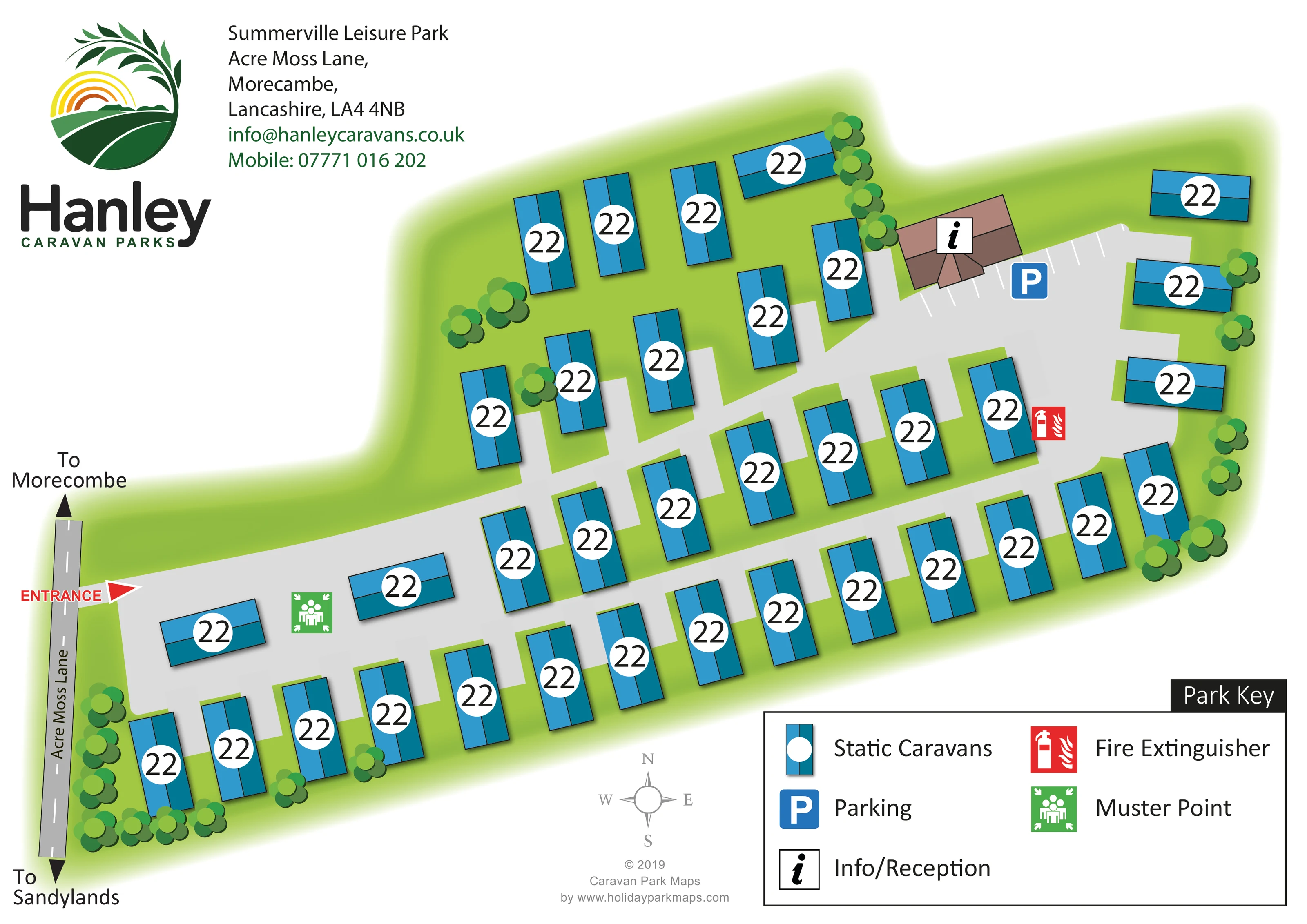
A brown, roof-shaped building towards the upper right carries the information symbol identified in the key as Info/Reception.
A blue parking symbol and white bay markings identify a parking area beside the reception building.
A red fire extinguisher symbol is placed beside the internal road in the right-hand part of the park.
A green muster-point symbol marks an open roadside area near the entrance end of the park.
A red ENTRANCE label and triangular arrow mark the connection from Acre Moss Lane into the internal road system.
Broad pale-grey roads form two long, roughly parallel runs with connecting branches and a wider area by reception.
Black arrows at either end of the illustrated Acre Moss Lane point towards Morecambe and Sandylands; the artwork spells the former destination 'Morecombe'.
A brown, roof-shaped building towards the upper right carries the information symbol identified in the key as Info/Reception.
A blue parking symbol and white bay markings identify a parking area beside the reception building.
A red fire extinguisher symbol is placed beside the internal road in the right-hand part of the park.
A green muster-point symbol marks an open roadside area near the entrance end of the park.
A red ENTRANCE label and triangular arrow mark the connection from Acre Moss Lane into the internal road system.
Broad pale-grey roads form two long, roughly parallel runs with connecting branches and a wider area by reception.
Black arrows at either end of the illustrated Acre Moss Lane point towards Morecambe and Sandylands; the artwork spells the former destination 'Morecombe'.
Green ground surrounds the caravans, with stylised tree clusters along the perimeter, around reception and between selected units.
READING THE MAP
This map of Summerville Leisure Park presents a compact static-caravan site on Acre Moss Lane in Morecambe, Lancashire. Its elongated layout runs diagonally across the page, with blue caravan symbols set against green grounds and broad grey access roads. The result is a clear overview of how the accommodation, entrance and reception area relate to one another, rather than a detailed street map of the surrounding town.
Arrival is given particular emphasis: a red entrance arrow connects the park to Acre Moss Lane, while destination arrows provide local context towards Morecambe and Sandylands. Reception and its adjacent parking area sit towards the opposite end of the site. A fire extinguisher point and muster point are also marked and explained in the substantial park key.
Large Hanley Caravan Parks branding anchors the upper-left corner. Rounded tree canopies, subtle building shadows and the softly fading green boundary give the otherwise geometric plan a recognisable landscaped character. This is a useful sample for a small holiday-home park needing straightforward site orientation alongside a prominent operator identity.
The single landscape-format artwork shows the park as an elongated green footprint, angled from the entrance at the lower left towards reception at the upper right. Acre Moss Lane runs along the left-hand edge, with a dashed centre line, its name set along the road and black arrows pointing towards the two named destinations. A red ENTRANCE label and triangular marker make the turn into the park easy to find.
Inside the site, broad pale-grey roads create two long, roughly parallel runs with short connecting sections. Static caravans occupy rows beside these roads, mostly positioned perpendicular to them. Smaller groups towards the upper edge and a handful of horizontally aligned units vary the otherwise regular arrangement. The depiction is of a small park, with approximately 40 caravan symbols rather than an extensive multi-zone development.
Reception stands out through its brown, multi-plane roof illustration and information marker. White parking-bay lines and a blue P symbol identify the neighbouring parking area. A red fire extinguisher icon appears beside the right-hand road, while the green muster-point symbol is positioned nearer the entrance. Trees soften the perimeter and punctuate selected spaces between caravans.
The lower-right key explains all five symbol types in a large bordered panel. A small compass sits below the plan, and the upper-left branding and address block occupy the principal white space. The two enlarged detail views show portions of this same artwork, including the key, compass and approach-road labels; they are not separate park sections or additional accommodation areas.
KEEP EXPLORING
Chosen for shared landscapes, accommodation or facilities.
 Explore the map ↗
United Kingdom
Coastal park map with static-caravan rows, touring pitches, a camping field and two leisure clusters.
 Explore the map ↗
United Kingdom
A wooded Allerton park plan with colour-coded neighbourhoods, touring pitches and a central facilities hub.
 Explore the map ↗
United Kingdom
Illustrated coastal holiday-home plan with dense alphanumeric plot labels, orange-roofed amenities, a numbered facility key and beach-side context.
Features may come from the sample artwork, its key or published park information. Approximate numbers describe the drawing and may cover only part of a park. They are intended to help you compare map examples. Current facilities and booking information should be checked with the park.
LET’S MAP YOUR PARK
For a map quotation, find your park and draw a rough boundary around it. The area you select helps us work out the design time and price.
Draw your park for a quote ↗Or talk to our map designers
01751 473136