
Communal lawns
Continuous green spaces surround the chalet blocks and separate them from parking and access routes.
ILLUSTRATED PARK MAP · P610
California Sands Estate, California, Great Yarmouth, Norfolk · United Kingdom
 Enlarge the map ↗
A SENSE OF THE PLACE
Sunbeach Holiday Village offers chalet accommodation in the California and Scratby coastal area of Norfolk. Communal lawns and parking areas sit around the holiday homes, with sandy beaches nearby.
Individually owned chalets are available through holiday letting providers. Some bookings include passes for the neighbouring Oasis leisure facilities; access depends on the particular chalet and provider rather than being assumed for every stay.
LOOK CLOSER
Continuous green spaces surround the chalet blocks and separate them from parking and access routes.
Stylised trees line the lower and right-hand boundaries, with larger trees along the upper edge and small planted circles within the chalet areas.
A red triangle and outlined entrance label mark the approach from the road along the bottom of the plan.
A broad white access spine branches towards parking courts, while thin grey paths curve through the accommodation lawns.
Several grey parking courts are positioned between chalet groups and beside the central service area, with white bay markings and blue P symbols.
A blue bin symbol marks the larger brown-roofed building in the central service cluster.
A spanner symbol identifies a small service building beside the main internal junction.
An illustrated slide and swings sit beside the central building and parking area.
Continuous green spaces surround the chalet blocks and separate them from parking and access routes.
Stylised trees line the lower and right-hand boundaries, with larger trees along the upper edge and small planted circles within the chalet areas.
A red triangle and outlined entrance label mark the approach from the road along the bottom of the plan.
A broad white access spine branches towards parking courts, while thin grey paths curve through the accommodation lawns.
Several grey parking courts are positioned between chalet groups and beside the central service area, with white bay markings and blue P symbols.
A blue bin symbol marks the larger brown-roofed building in the central service cluster.
A spanner symbol identifies a small service building beside the main internal junction.
An illustrated slide and swings sit beside the central building and parking area.
A red extinguisher symbol is placed by the central service area.
A blue BUS marker appears on the bottom boundary road, to the right of the entrance.
An outward arrow at the lower-right corner is labelled 'To The Beach'; the beach itself is outside the depicted site.
A left-pointing arrow on the bottom road provides wider local orientation.
A long yellow arrow from the left-hand panel points to the internal junction beside the maintenance building.
Included in the map key, without a clearly located matching symbol on this plan.
A washing-machine symbol is included in the key, but its location is not shown on the depicted site.
Named in the map key; no matching facility marker is placed within the Sunbeach plan.
Named in the key rather than located on the plan. Supplied park context also refers to neighbouring Oasis leisure facilities.
Represented by a colourful slot-machine graphic in the key, without a mapped location.
Listed in the key using a fish pictogram; no corresponding position is marked on this plan.
A wine-glass pictogram appears in the key, without a located restaurant marker.
Named in the key with a swimmer pictogram; the pool is not positioned within the illustrated Sunbeach site.
READING THE MAP
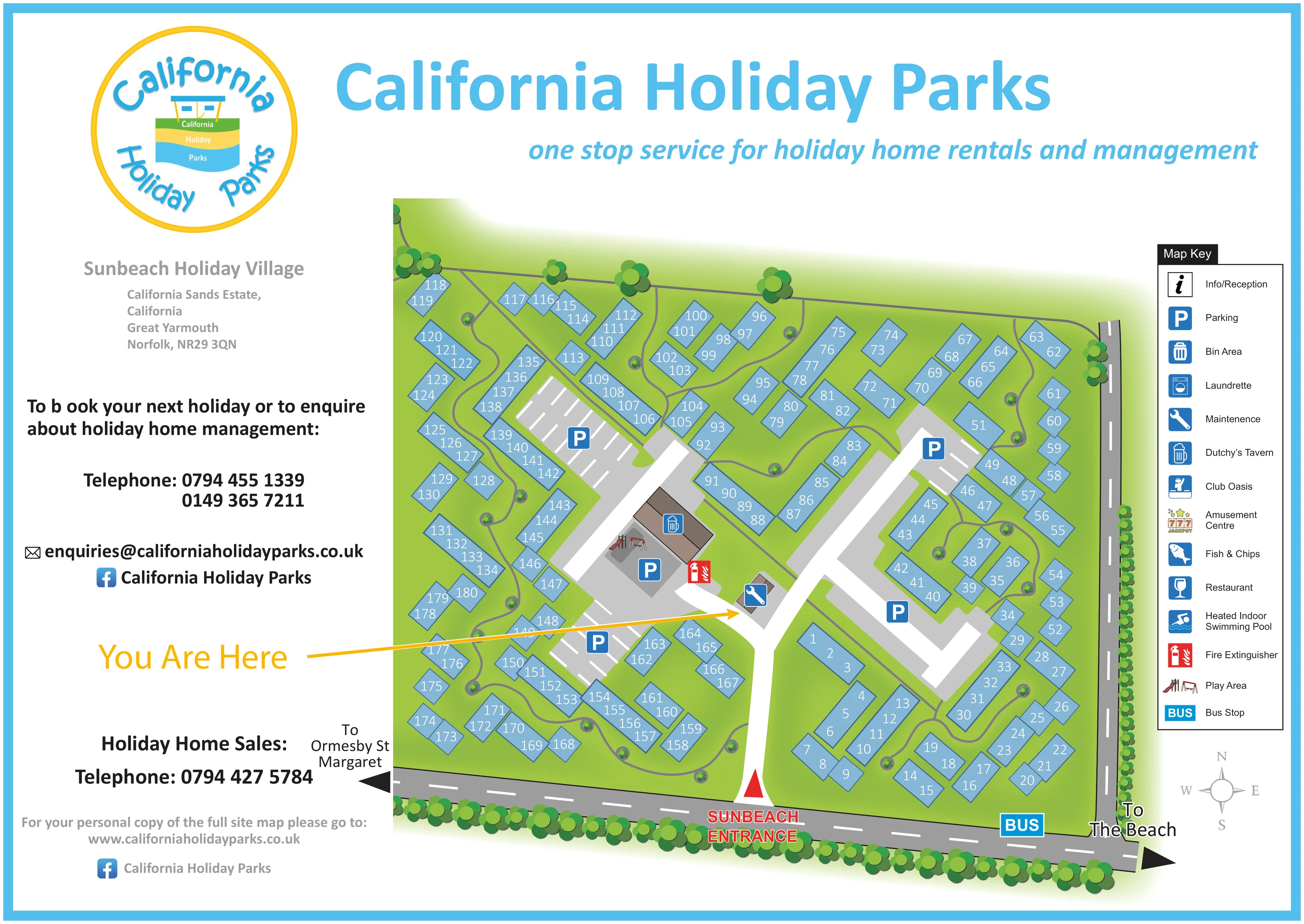
This map of Sunbeach Holiday Village presents a compact chalet community in the California and Scratby coastal area near Great Yarmouth, Norfolk. Numbered blue accommodation blocks sit across bright green communal lawns, with parking courts and winding paths breaking the village into easy-to-recognise groups. The beach is indicated by an outward direction arrow rather than drawn as part of the site, keeping the plan focused on finding a holiday home and understanding the immediate surroundings.
The artwork combines a practical site plan with a substantial California Holiday Parks information panel. A large brand heading and circular logo frame the page, while the Sunbeach name and address establish the individual location. The entrance, roadside bus stop and central service area provide useful arrival landmarks. A particularly prominent yellow You Are Here arrow points into the plan from the left-hand column.
For a chalet park with many similar-looking homes, the design prioritises clear numbering, shared parking and the relationship between buildings and open space. Its simple overhead view makes those everyday navigation details more prominent than architectural detail.
The plan places Sunbeach’s main entrance along the lower boundary road, with a broad white access route running into the centre of the village. Branching routes lead towards grey parking courts on both sides. White bay lines and blue P symbols make these shared parking areas distinct from the surrounding green lawns. Narrower grey paths curve between the accommodation blocks, creating a separate visual layer for local connections.
Around 180 chalet-style holiday homes are represented by light-blue rectangles with dark outlines. Most rectangles contain several white home numbers, expressing the grouped nature of the buildings without drawing every individual doorway. Blocks sit at varied angles rather than in one rigid grid, and the open spaces between them contain small circular planting motifs. Larger stylised trees line the upper boundary, while denser rows of trees soften the roads along the bottom and right-hand edges.
Near the central junction, brown-roofed service buildings, a bin marker, a maintenance symbol, a fire-extinguisher marker and illustrated play equipment form a recognisable landmark cluster. The yellow You Are Here arrow points beside this area. Along the lower road, a BUS symbol identifies a stop, and arrows indicate the beach to the right and Ormesby St Margaret to the left.
The right-hand key explains the mapped symbols and also lists reception, a laundrette, Dutchy’s Tavern, Club Oasis, an amusement centre, food outlets and a heated indoor swimming pool without locating them on this particular plan. A compass sits below the key. The accompanying close-up enlarges this same artwork’s key and eastern accommodation area; it is not a separate site or additional accommodation section.
KEEP EXPLORING
Chosen for shared landscapes, accommodation or facilities.
 Explore the map ↗
United Kingdom
Coastal park map with static-caravan rows, touring pitches, a camping field and two leisure clusters.
 Explore the map ↗
United Kingdom
A colour-zoned coastal park map with touring areas, woodland trails, ponds and a leisure club.
 Explore the map ↗
United Kingdom
Colour-coded accommodation, central leisure facilities and coastal paths on an illustrated headland park map.
Features may come from the sample artwork, its key or published park information. Approximate numbers describe the drawing and may cover only part of a park. They are intended to help you compare map examples. Current facilities and booking information should be checked with the park.
LET’S MAP YOUR PARK
For a map quotation, find your park and draw a rough boundary around it. The area you select helps us work out the design time and price.
Draw your park for a quote ↗Or talk to our map designers
01751 473136