
Amenity areas
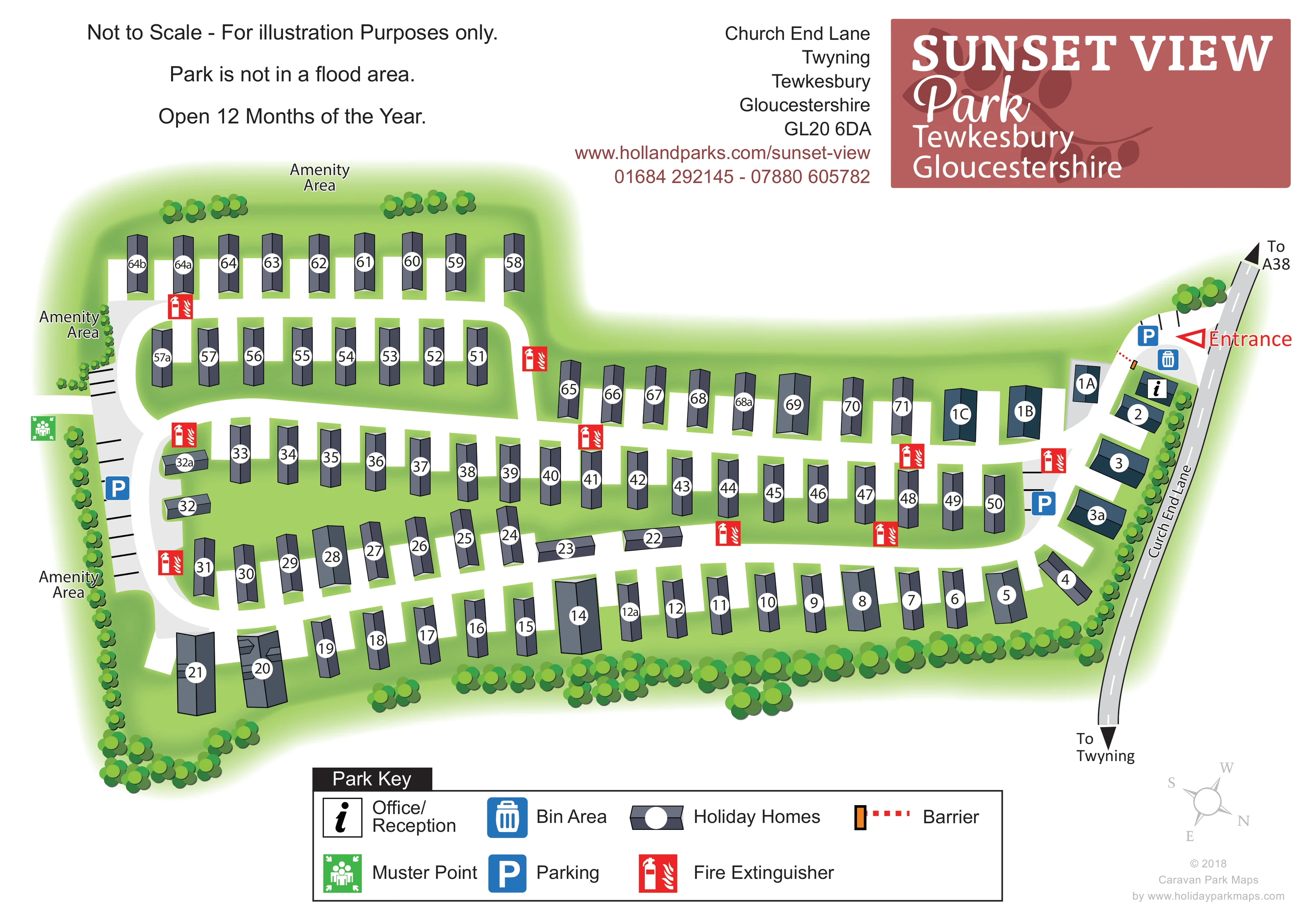
Grassed margins above and along the left side of the homes are labelled Amenity Area; no specific recreation equipment is depicted.
ILLUSTRATED PARK MAP · P612
Church End Lane, Twyning, Tewkesbury, Gloucestershire · United Kingdom
 Enlarge the map ↗
A SENSE OF THE PLACE
Sunset View Park is a holiday home development at Twyning near Tewkesbury in Gloucestershire. It is intended for owners and their family and friends, with a focus on quieter leisure time.
Gated access supports the private setting, and families and pets are welcomed. The map shows the arrangement of holiday homes and internal roads within the grounds.
LOOK CLOSER
Grassed margins above and along the left side of the homes are labelled Amenity Area; no specific recreation equipment is depicted.
Stylised trees form a substantial border along the lower and left edges, continue beside Church End Lane and appear in smaller groups around the upper amenity area.
An information symbol marks the office/reception building beside the entrance on the Church End Lane side.
Blue parking symbols and black bay markings identify parking near the entrance, beside the right-hand internal road and along the left-hand edge.
A blue bin symbol marks a bin area close to the entrance and reception.
Repeated red extinguisher symbols are distributed beside roads throughout the accommodation layout.
A green muster-point symbol appears on the left-hand side near the parking strip and amenity space.
A large red entrance pointer identifies the access from Church End Lane, with a barrier symbol across the entrance drive.
An information symbol marks the office/reception building beside the entrance on the Church End Lane side.
Blue parking symbols and black bay markings identify parking near the entrance, beside the right-hand internal road and along the left-hand edge.
A blue bin symbol marks a bin area close to the entrance and reception.
Repeated red extinguisher symbols are distributed beside roads throughout the accommodation layout.
A green muster-point symbol appears on the left-hand side near the parking strip and amenity space.
Grassed margins above and along the left side of the homes are labelled Amenity Area; no specific recreation equipment is depicted.
Stylised trees form a substantial border along the lower and left edges, continue beside Church End Lane and appear in smaller groups around the upper amenity area.
A large red entrance pointer identifies the access from Church End Lane, with a barrier symbol across the entrance drive.
Broad white roads connect long accommodation rows with rounded turns, including a smaller loop around the upper-left group.
The grey public road runs diagonally along the right edge, with arrows towards the A38 at the top and Twyning at the bottom.
READING THE MAP
This illustrated map presents Sunset View Park at Twyning, near Tewkesbury in Gloucestershire, as a compact holiday-home development framed by trees and green amenity space. Around 75 homes are shown in numbered rows, with broad white internal roads making the arrangement easy to follow against the green grounds. A smaller loop at the upper left gives the plan a distinctive stepped shape, while Church End Lane forms the diagonal boundary on the right.
The entrance receives particular emphasis: a red pointer leads the eye towards the barrier, reception, bin area and nearby parking. Other practical symbols identify parking areas, fire extinguisher points and a muster point without competing with the accommodation numbers. Labels for the amenity areas help explain the open margins around the homes.
The design combines a straightforward overhead layout with lightly dimensional roofs and rounded tree illustrations. A substantial key below the plan and a muted red title panel above it complete a self-contained visitor map, balancing individual-home identification with a clear introduction to the park’s overall organisation.
The main plan follows an elongated footprint, with an upper-left extension and a roadside entrance at the right. Church End Lane is drawn as a grey diagonal road with a dashed centre line; arrows at its ends point towards the A38 and Twyning. Just inside the entrance, the map groups the barrier, office/reception, bin area and parking, making the arrival sequence visually distinct from the accommodation rows.
Inside the grounds, wide white roads run between long lines of holiday homes and connect through rounded bends. A separate-looking but connected loop wraps around the upper-left group. Most homes are illustrated as narrow, two-tone roof forms, while several broader buildings introduce variation. Their orientation changes around bends and along the roadside edge. Large white number discs make each home identifiable without requiring detailed building drawings.
Green amenity margins lie above and to the left of the accommodation. Layered circles of foliage mark trees along the lower boundary, down the left edge and beside Church End Lane, with smaller clusters near the upper homes. Parking bays are indicated by short black strokes and blue parking signs. Red fire extinguisher markers recur around the roads, and a green muster-point symbol sits beside the left-hand parking area.
A two-row Park Key spans the lower centre of the page. Above the illustration, the title panel, address block and explanatory text occupy the white page margin rather than covering the site. The lower-right compass is deliberately rotated to match the plan’s orientation. The accompanying detail views enlarge the same legend and footer; they do not depict additional accommodation or separate sections of the park.
KEEP EXPLORING
Chosen for shared landscapes, accommodation or facilities.
 Explore the map ↗
United Kingdom
Coastal park map with static-caravan rows, touring pitches, a camping field and two leisure clusters.
 Explore the map ↗
United Kingdom
A wooded Allerton park plan with colour-coded neighbourhoods, touring pitches and a central facilities hub.
 Explore the map ↗
United Kingdom
Illustrated coastal holiday-home plan with dense alphanumeric plot labels, orange-roofed amenities, a numbered facility key and beach-side context.
Features may come from the sample artwork, its key or published park information. Approximate numbers describe the drawing and may cover only part of a park. They are intended to help you compare map examples. Current facilities and booking information should be checked with the park.
TAKE A CLOSER LOOK
View the illustrated map in detail or choose a file to download. These are sample maps; contact the park for current visitor information.


LET’S MAP YOUR PARK
For a map quotation, find your park and draw a rough boundary around it. The area you select helps us work out the design time and price.
Draw your park for a quote ↗Or talk to our map designers
01751 473136