
Firs Lawns, Middle Field and Long Meadow
Three named areas organise the accommodation, with broad green spaces retained between and within the rows.
ILLUSTRATED PARK MAP · P613
Vale Road, Dover, Kent · United Kingdom
 Enlarge the map ↗
A SENSE OF THE PLACE
Sutton Vale Country Park provides self-catering accommodation in the Kent countryside near Deal and Dover. Its grounds offer a quieter base within reach of the county's south coast.
The local visitor listing highlights apartments and the surrounding countryside setting. Dover's White Cliffs and the coastal towns provide options for excursions, while the map presents the layout of the holiday grounds.
LOOK CLOSER
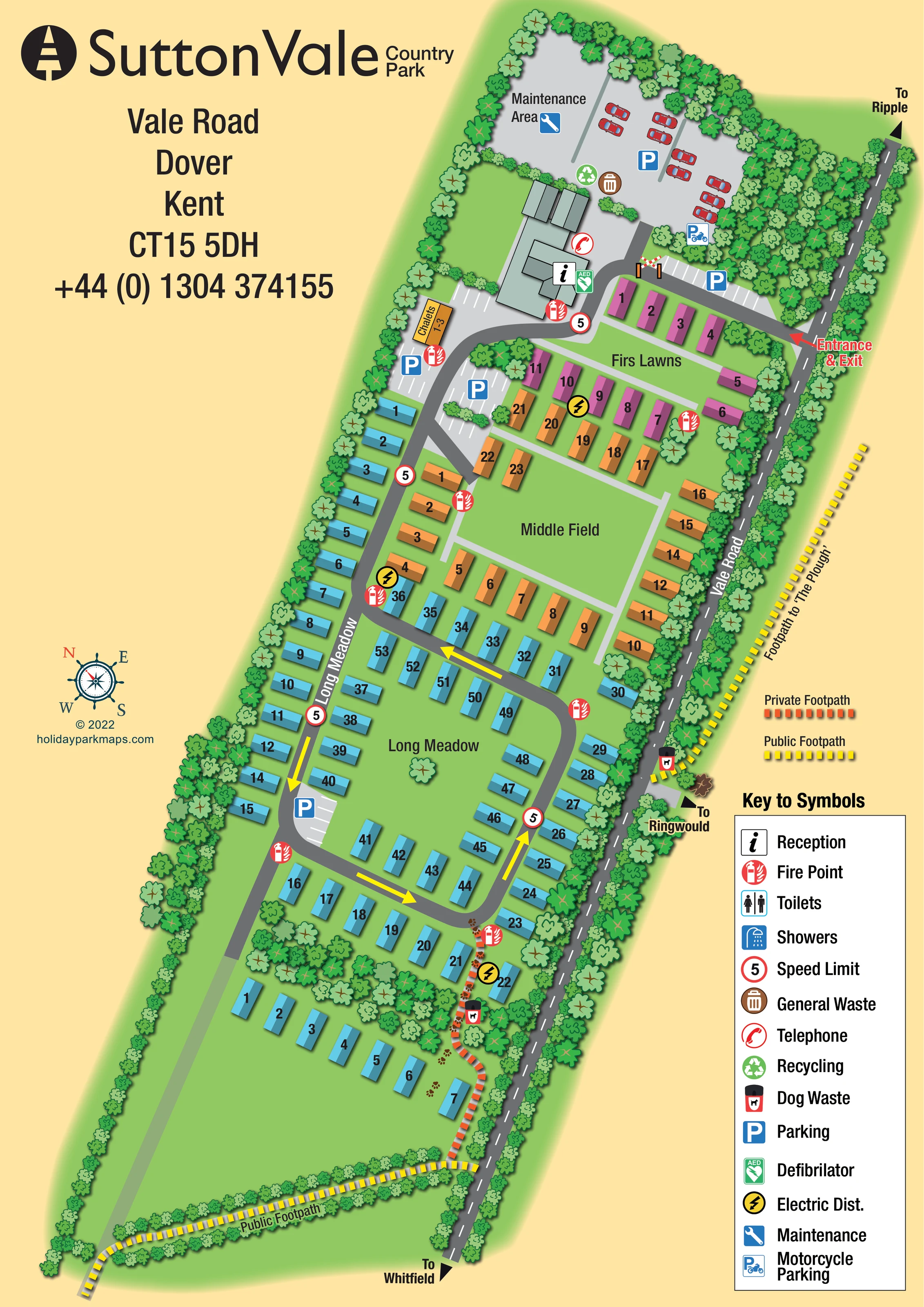
Three named areas organise the accommodation, with broad green spaces retained between and within the rows.
Dense illustrated trees and hedges enclose the elongated grounds, screen Vale Road and divide parts of the accommodation layout.
An information symbol identifies reception within the main grey-roofed building group near the entrance.
A labelled chalet block stands beside parking on the western side of the arrival area.
Blue parking symbols and white bay markings identify several parking areas, including the entrance frontage, upper compound and spaces beside accommodation roads.
A motorcycle parking symbol appears near the upper buildings and entrance-side parking.
The northern compound is labelled 'Maintenance Area' and includes a spanner symbol, parked vehicles and adjoining parking.
A red telephone symbol is placed beside the main building group.
An information symbol identifies reception within the main grey-roofed building group near the entrance.
A labelled chalet block stands beside parking on the western side of the arrival area.
Blue parking symbols and white bay markings identify several parking areas, including the entrance frontage, upper compound and spaces beside accommodation roads.
A motorcycle parking symbol appears near the upper buildings and entrance-side parking.
The northern compound is labelled 'Maintenance Area' and includes a spanner symbol, parked vehicles and adjoining parking.
A red telephone symbol is placed beside the main building group.
A green AED symbol is positioned at the reception building group.
Repeated red fire-point symbols are distributed around the arrival area and accommodation roads.
General waste and recycling symbols are grouped beside the upper service and parking area.
Dog-waste bin symbols appear beside the eastern public footpath and the southern private walking route.
Yellow lightning symbols mark several electrical distribution points within the accommodation layout.
A toilet symbol is included in the key; no corresponding position is clearly identifiable on the plan.
A shower symbol is included in the key; no corresponding position is clearly identifiable on the plan.
Three named areas organise the accommodation, with broad green spaces retained between and within the rows.
Dense illustrated trees and hedges enclose the elongated grounds, screen Vale Road and divide parts of the accommodation layout.
A prominently labelled entrance and exit connects Vale Road to the upper arrival area, where a barrier is illustrated.
Dark-grey roads connect the entrance to a long western spine and a lower loop. Yellow arrows indicate the depicted direction of travel around the Long Meadow circuit.
Red-ringed signs marked '5' recur along the internal roads.
Yellow dashed paths follow the southern boundary and run outside the eastern side of Vale Road; the eastern route is labelled as a footpath to 'The Plough'.
An orange dashed route winds through the southern planting and accommodation edge towards the southern public footpath.
Vale Road forms the eastern edge, with direction pointers towards Ripple, Ringwould and Whitfield.
READING THE MAP
This illustrated map of Sutton Vale Country Park presents a long, tree-lined holiday site on Vale Road in the Kent countryside near Dover and Deal. The portrait composition follows the shape of the grounds, placing the entrance, reception buildings and maintenance area towards the top, with accommodation extending through Firs Lawns, Middle Field and Long Meadow below.
Blue, orange and purple accommodation symbols make the different parts of the plan easy to distinguish, while bold unit numbers and large area names provide practical reference points. The map also shows a small chalet group, several parking areas and a road circuit marked with yellow directional arrows. Dense boundary planting gives the artwork a recognisable rural character without obscuring the routes.
Walking connections are a particularly useful part of this sample. Public footpaths are picked out in yellow, including a route towards 'The Plough', while an orange private footpath winds through the southern end of the grounds. A substantial symbol key, prominent entrance label and local direction pointers bring accommodation, facilities and surrounding access together on one visitor-facing page.
The plan is arranged diagonally across a pale cream-yellow portrait page, allowing the park’s narrow footprint to remain large and readable. Vale Road runs along the eastern side, with pointers towards Ripple, Ringwould and Whitfield. The entrance and exit lead into a compact arrival area containing reception, a telephone symbol, an AED marker and marked parking. Beyond the main buildings, a separate northern compound is labelled as the maintenance area and includes vehicle parking, recycling and general waste symbols. Motorcycle parking is also identified near the upper buildings.
Accommodation is organised into three named areas. Purple units occupy Firs Lawns near the entrance, orange units surround Middle Field, and blue units extend through Long Meadow and into the southern grounds. A separate block beside the arrival area is labelled 'Chalets 1–3'. The coloured units have simple shaded roof forms and large black numbers; the artwork does not provide a key explaining what the accommodation colours signify.
A dark-grey road follows the western side and forms a loop around the open centre of Long Meadow. Yellow arrows make the depicted circulation clear, while red-ringed speed markers and repeated fire-point symbols provide additional route information. Pale-grey links divide the upper accommodation rows, and white bay markings distinguish parking from surrounding hardstanding.
Tree and hedge illustrations form dense outer boundaries and smaller internal screens. Yellow dashed public footpaths follow the southern boundary and the eastern roadside, including the labelled route to 'The Plough'. An orange dashed private footpath winds through the southern planting, with dog-waste symbols shown beside walking routes. The lower-right legend explains the facility symbols and path styles; toilets and showers are listed there without clearly identifiable map positions. The accompanying enlargement is a closer view of this same plan, not a separate map variant.
KEEP EXPLORING
Chosen for shared landscapes, accommodation or facilities.
 Explore the map ↗
United Kingdom
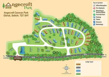
Tree-framed Angecroft Park map with colour-coded roofs, looping roads and a signed B709 entrance.
 Explore the map ↗
United Kingdom
Ashby Park map with seven fishing lakes, colour-coded accommodation and illustrated wooded shorelines.
 Explore the map ↗
United Kingdom
Woodland-framed Barnsoul map with mixed accommodation, shared facilities and paw-marked walking routes.
Features may come from the sample artwork, its key or published park information. Approximate numbers describe the drawing and may cover only part of a park. They are intended to help you compare map examples. Current facilities and booking information should be checked with the park.
LET’S MAP YOUR PARK
For a map quotation, find your park and draw a rough boundary around it. The area you select helps us work out the design time and price.
Draw your park for a quote ↗Or talk to our map designers
01751 473136