
Northern Lakeside lake
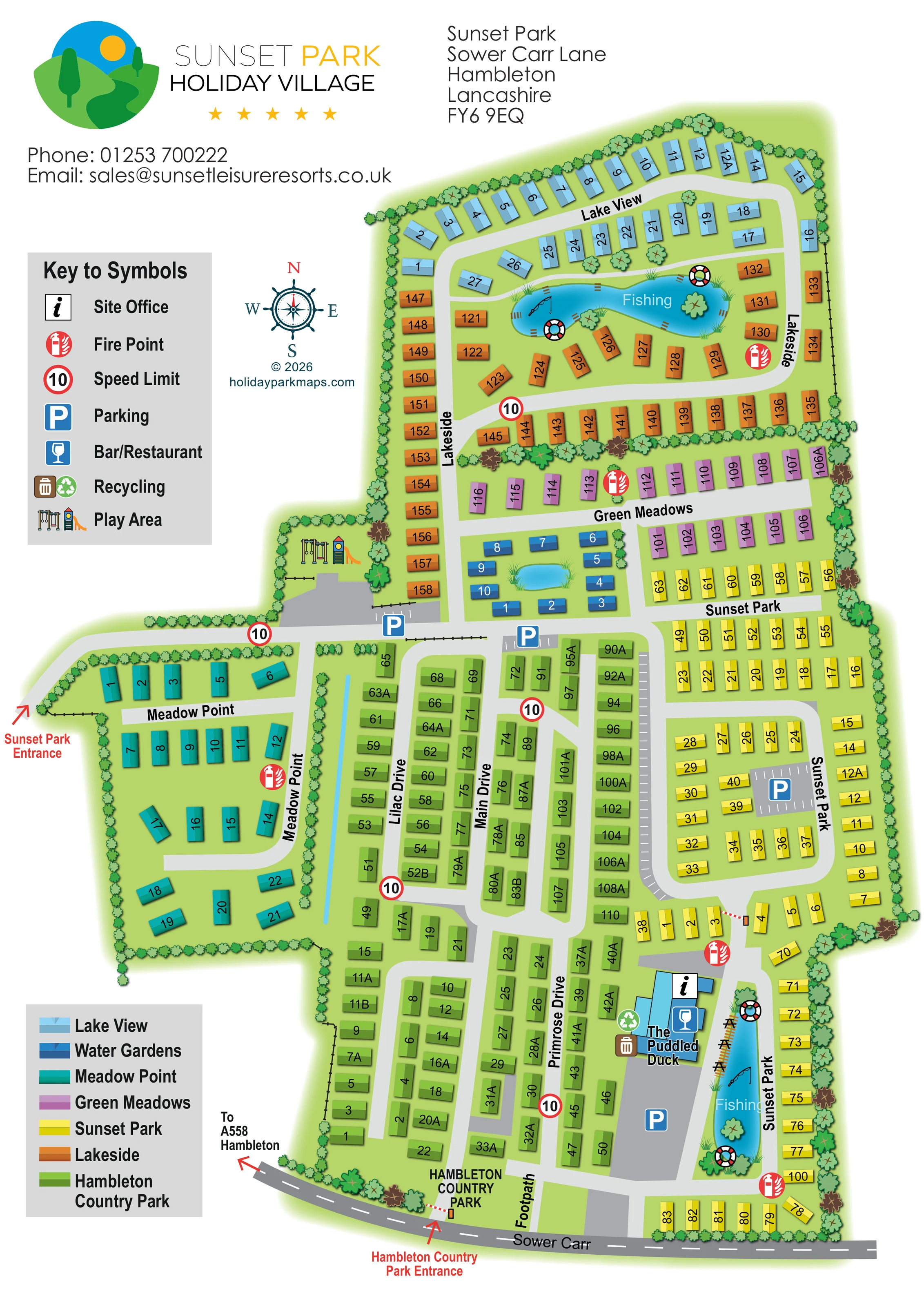
An irregular blue lake forms the centrepiece of the orange Lakeside accommodation area, with reeds, small waterside details and lifebuoy illustrations.
ILLUSTRATED PARK MAP · P322
Sower Carr Lane, Hambleton · United Kingdom
 Enlarge the map ↗
A SENSE OF THE PLACE
Sunset Park is based at Sower Carr Lane, Hambleton. Sunset Park is part of the family-run Sunset Leisure Resorts business. The park offers holiday homes and single or twin lodges.
Its Lakeside development has holiday-home plots around a fishing lake.
LOOK CLOSER
An irregular blue lake forms the centrepiece of the orange Lakeside accommodation area, with reeds, small waterside details and lifebuoy illustrations.
A narrow, elongated blue pond lies alongside the Sunset Park road and amenity building, with reeds, a timber-coloured waterside edge and lifebuoy illustrations.
A small ornamental-looking pond sits within a compact group of dark-blue accommodation blocks in Water Gardens; it is not labelled as a fishing water.
A slim blue channel separates Meadow Point from part of the green Hambleton Country Park accommodation area.
Repeated tree and shrub symbols enclose the site, divide neighbourhoods and punctuate waterside spaces.
An information symbol locates the site office at the building cluster beside The Puddled Duck in the lower-right part of the plan.
A named blue building beside the long southern fishing pond carries the bar/restaurant symbol.
Illustrated swings and a slide sit in a tree-enclosed pocket beside the junction between Meadow Point, Lakeside and the central accommodation areas.
An information symbol locates the site office at the building cluster beside The Puddled Duck in the lower-right part of the plan.
A named blue building beside the long southern fishing pond carries the bar/restaurant symbol.
Illustrated swings and a slide sit in a tree-enclosed pocket beside the junction between Meadow Point, Lakeside and the central accommodation areas.
Blue parking symbols and marked bays identify parking near the play area, Water Gardens, the eastern Sunset Park loop and the southern amenity building.
Paired recycling and bin symbols are positioned beside The Puddled Duck.
Repeated red fire-point symbols are distributed through the accommodation areas and beside the southern fishing pond.
Two waters are explicitly labelled Fishing: the northern lake within Lakeside and the elongated pond beside The Puddled Duck. Fishing-rod illustrations reinforce their use.
An irregular blue lake forms the centrepiece of the orange Lakeside accommodation area, with reeds, small waterside details and lifebuoy illustrations.
A narrow, elongated blue pond lies alongside the Sunset Park road and amenity building, with reeds, a timber-coloured waterside edge and lifebuoy illustrations.
A small ornamental-looking pond sits within a compact group of dark-blue accommodation blocks in Water Gardens; it is not labelled as a fishing water.
A slim blue channel separates Meadow Point from part of the green Hambleton Country Park accommodation area.
Repeated tree and shrub symbols enclose the site, divide neighbourhoods and punctuate waterside spaces.
A red arrow identifies the western entrance leading into Meadow Point and the principal cross-site road.
A separately labelled entrance joins Sower Carr at the southern edge of the green accommodation section.
The southern boundary road is labelled Sower Carr, with an outward arrow reading To A558 Hambleton.
A route labelled Footpath runs northwards from the southern road into the central green section.
Main Drive, Lilac Drive and Primrose Drive structure the green section, while neighbourhood names also label roads through the other accommodation areas.
Repeated red-ringed 10 symbols appear on the internal road network, matching the speed-limit entry in the key.
READING THE MAP
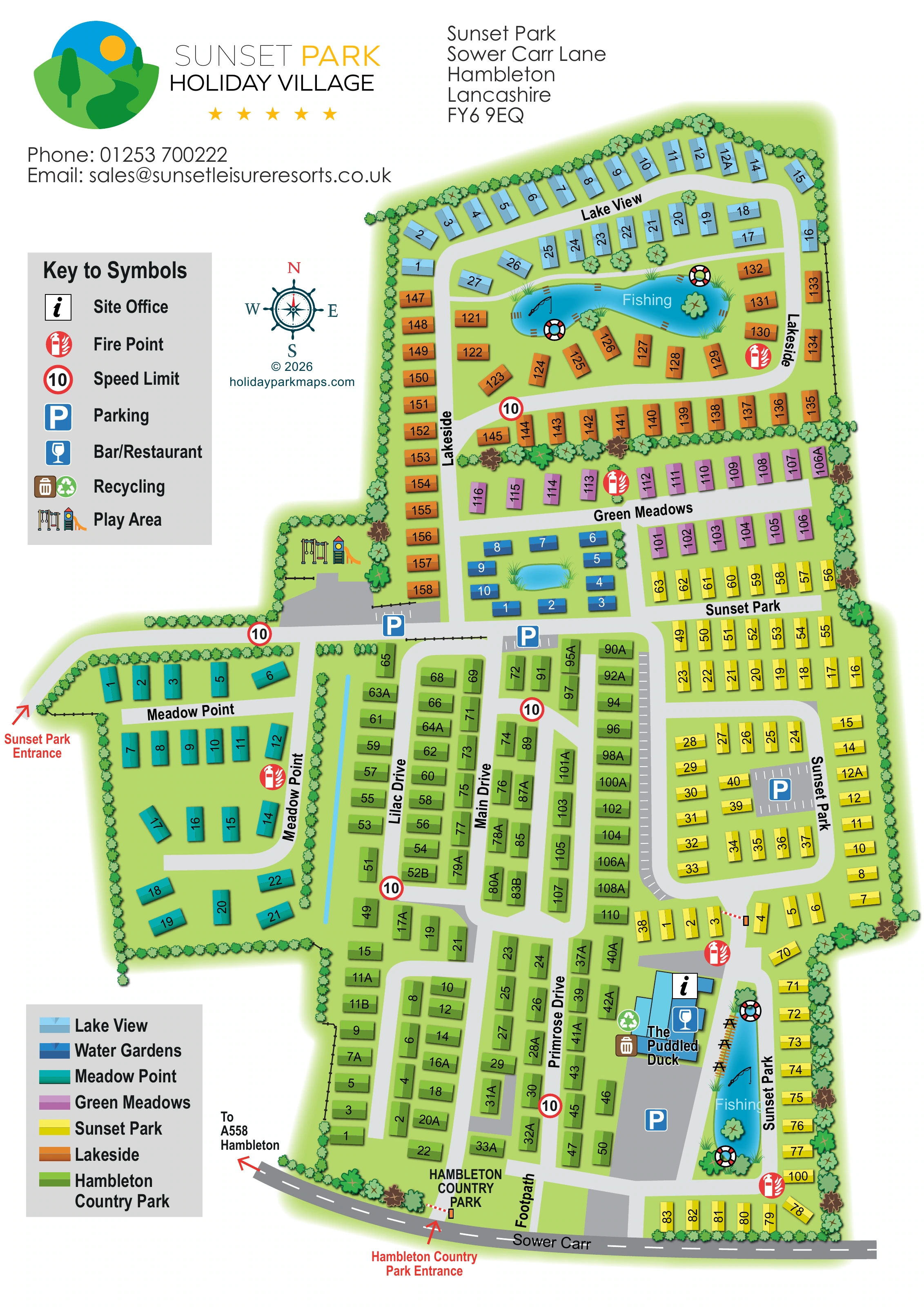
This map of Sunset Park Holiday Village in Hambleton, Lancashire, shows how a large holiday-home development can be made readable through clearly defined neighbourhoods. Seven accommodation colours distinguish Lake View, Water Gardens, Meadow Point, Green Meadows, Sunset Park, Lakeside and the adjoining section labelled Hambleton Country Park. The result is a single plan that explains both the overall site and the smaller areas visitors need to find.
Water provides several useful landmarks. A fishing lake sits within Lakeside at the northern end, a second fishing pond lies beside The Puddled Duck towards the south, and a smaller pond gives Water Gardens its own visual focus. Tree-lined boundaries and planted divisions help separate the accommodation groups without obscuring the road network.
The artwork combines numbered accommodation blocks with named roads, parking symbols, a play area and clearly marked entrances. Its portrait composition leaves room for the park branding, contact details, compass and two separate keys. This sample is particularly relevant to parks with several named developments that need to work together on one visitor-facing map.
The plan is organised around a connected pale-grey road network, with accommodation arranged in loops, parallel rows and smaller landscaped groups. At the northern tip, light-blue Lake View follows the outer boundary. Immediately below, orange Lakeside wraps around an irregular fishing lake. Mauve Green Meadows forms a pair of rows beneath this area, while the compact dark-blue Water Gardens group surrounds a small pond near the central junction.
Meadow Point projects westwards from the main site and is shown in teal, with a curving internal road and a strongly planted perimeter. Yellow Sunset Park accommodation occupies much of the eastern side. The large green section labelled Hambleton Country Park extends through the centre and south, structured by Lilac Drive, Main Drive and Primrose Drive. A narrow blue water feature lies between this section and Meadow Point.
Two red entrance arrows distinguish the western Sunset Park approach from the Hambleton Country Park entrance on Sower Carr. The southern boundary road also carries a direction towards the A558 at Hambleton. Within the site, parking courts, repeated fire-point symbols and red-ringed speed markers add practical information. A play area with swings and a slide sits near the western-central junction. Further south, The Puddled Duck is labelled beside an elongated fishing pond, with office, bar/restaurant, recycling and parking symbols nearby. A separate route is labelled Footpath.
The portrait page balances this detailed plan with a spacious header and left-hand information column. One key explains facilities; the other identifies all seven neighbourhood colours. The enlarged detail view shows the same artwork, making the facility key and Meadow Point area easier to read rather than adding another map section.
KEEP EXPLORING
Chosen for shared landscapes, accommodation or facilities.
 Explore the map ↗
United Kingdom
Illustrated lakeside park plan with numbered holiday units, leisure buildings and a looping Woodland Walk.
 Explore the map ↗
United Kingdom
Tree-lined caravan park plan with linked road loops, a central pond and an illustrated fishing lake.
 Explore the map ↗
United Kingdom
A lakeside holiday-park and fishery map with numbered accommodation, fishing positions and clearly grouped visitor services.
Features may come from the sample artwork, its key or published park information. Approximate numbers describe the drawing and may cover only part of a park. They are intended to help you compare map examples. Current facilities and booking information should be checked with the park.
TAKE A CLOSER LOOK
View the illustrated map in detail or choose a file to download. These are sample maps; contact the park for current visitor information.


LET’S MAP YOUR PARK
For a map quotation, find your park and draw a rough boundary around it. The area you select helps us work out the design time and price.
Draw your park for a quote ↗Or talk to our map designers
01751 473136
 sunsetpark_large.png