
Tree-lined estate boundary
Continuous or closely spaced illustrated trees frame much of the northern and western boundary, with further planting along the eastern edge and Bakers Lane frontage.
ILLUSTRATED PARK MAP · P616
Bakers Lane, West Hanningfield, Chelmsford, Essex · United Kingdom
 Enlarge the map ↗
A SENSE OF THE PLACE
Templeton Park is based at Bakers Lane, West Hanningfield, Chelmsford, Essex. This is a residential park-home estate near Chelmsford, aimed primarily at retired and semi-retired residents. The estate markets both new and pre-owned park homes.
The operator explicitly states that the estate holds a full residential licence for year-round occupation.
LOOK CLOSER
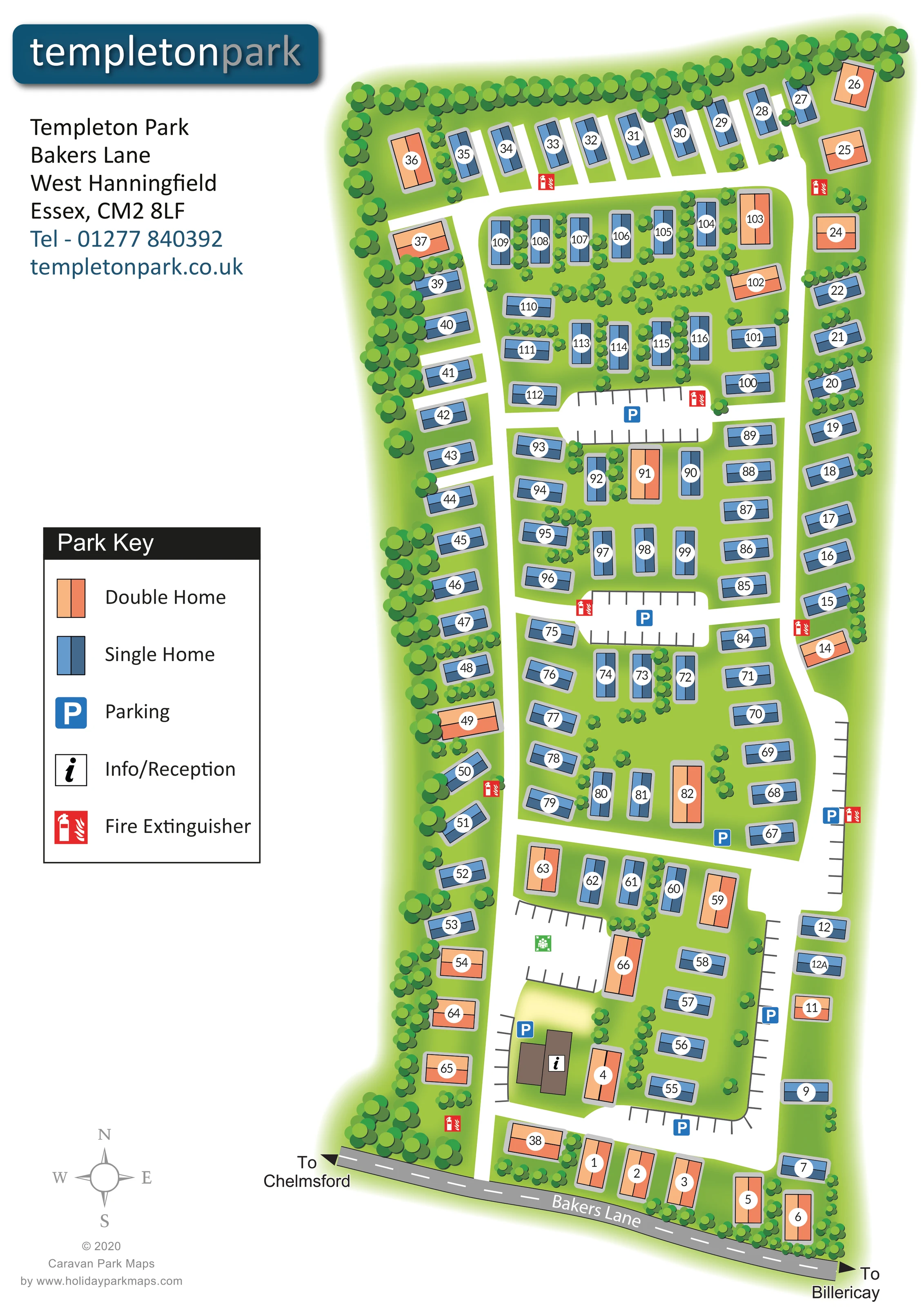
Continuous or closely spaced illustrated trees frame much of the northern and western boundary, with further planting along the eastern edge and Bakers Lane frontage.
Smaller tree and shrub clusters divide home groups and occupy green spaces between the internal roads.
A brown, two-part building marked with an information symbol stands near the southern entrance, within the lower internal road loop.
Blue P symbols identify parking throughout the estate. The artwork includes two prominent central parking courts, roadside bays on the eastern side and parking around the reception area.
Repeated red extinguisher symbols appear beside internal roads, parking courts and perimeter home rows; the key identifies their meaning.
A green assembly-point pictogram is placed in the marked court immediately north of reception. It is visible on the plan but is not explained in the printed key.
Bakers Lane is labelled along the southern edge. An opening from this road connects directly to the internal estate road network near reception.
White roads run north along both sides of the estate and connect through cross-routes, dividing the elongated site into several residential blocks.
A brown, two-part building marked with an information symbol stands near the southern entrance, within the lower internal road loop.
Blue P symbols identify parking throughout the estate. The artwork includes two prominent central parking courts, roadside bays on the eastern side and parking around the reception area.
Repeated red extinguisher symbols appear beside internal roads, parking courts and perimeter home rows; the key identifies their meaning.
A green assembly-point pictogram is placed in the marked court immediately north of reception. It is visible on the plan but is not explained in the printed key.
Continuous or closely spaced illustrated trees frame much of the northern and western boundary, with further planting along the eastern edge and Bakers Lane frontage.
Smaller tree and shrub clusters divide home groups and occupy green spaces between the internal roads.
Bakers Lane is labelled along the southern edge. An opening from this road connects directly to the internal estate road network near reception.
White roads run north along both sides of the estate and connect through cross-routes, dividing the elongated site into several residential blocks.
Arrowheads at opposite ends of Bakers Lane indicate Chelmsford to the left and Billericay to the right.
A four-point compass in the lower-left margin gives north, east, south and west orientation.
READING THE MAP
This illustrated map of Templeton Park shows a residential park-home estate at West Hanningfield, near Chelmsford in Essex. The long, tree-lined site extends north from Bakers Lane, with numbered homes arranged around linked internal roads and shared parking areas. Rather than presenting holiday pitches or leisure zones, the design concentrates on the everyday task of finding a particular home, locating reception and understanding the estate’s circulation.
Two contrasting colours make the housing mix immediately legible: blue for single homes and peach-orange for double homes. White circular number labels remain prominent against both colours, while green planting gives the plan a clear landscape frame. Parking courts and roadside bays are drawn directly into the road layout, supported by familiar blue P symbols.
The portrait page reserves a generous left-hand column for the Templeton Park branding, contact details and an easily scanned key. A compass and directions towards Chelmsford and Billericay complete the orientation information. It is a useful sample for residential estates needing a complete, numbered site plan with simple building categories and practical arrival landmarks.
The plan presents Templeton Park as an elongated estate running inland from Bakers Lane. The main entrance is shown near the lower-left part of the frontage, leading towards a brown information/reception building. From here, white internal roads connect the southern home groups with routes extending along both sides of the estate. Cross-connections divide the interior into a series of residential blocks, while the northern road curves around the uppermost group.
Homes line the outer edges and occupy smaller rows within the centre. Their varied orientations follow the road pattern and irregular boundary rather than a rigid page-wide grid. The key distinguishes narrow blue single homes from broader peach-and-orange double homes. Each footprint has a grey surround, a black outline and a white circular number label. A group of double homes gives the Bakers Lane frontage a particularly warm colour accent.
Parking is integral to the drawing. Two sizeable courts interrupt the central home groups, and further marked bays follow the eastern road and surround the lower reception area. Blue parking symbols reinforce these locations. Red fire-extinguisher pictograms recur beside roads and courts, and a green assembly-point symbol appears in the court north of reception.
Layered circular tree symbols frame the boundaries and form smaller planted divisions between homes. The green site surface fades gently into the white page. Outside the estate, Bakers Lane has a grey carriageway, dashed centre markings and arrows towards Chelmsford and Billericay. The left-hand branding, address block, five-entry key and compass balance the tall plan. The accompanying enlarged views show overlapping portions of this same single-page artwork, not separate estate sections.
KEEP EXPLORING
Chosen for shared landscapes, accommodation or facilities.
 Explore the map ↗
United Kingdom
Illustrated Sanday aire map with a seasonal maze, café barn and motorhome service area.
 Explore the map ↗
United Kingdom
Illustrated coastal campsite plan with named fields, electric pitch colours, beach routes and the Afon Hen.
 Explore the map ↗
United Kingdom
A woodland touring-park map with colour-coded pitches, a stream and footprint-marked walks.
Features may come from the sample artwork, its key or published park information. Approximate numbers describe the drawing and may cover only part of a park. They are intended to help you compare map examples. Current facilities and booking information should be checked with the park.
TAKE A CLOSER LOOK
View the illustrated map in detail or choose a file to download. These are sample maps; contact the park for current visitor information.


LET’S MAP YOUR PARK
For a map quotation, find your park and draw a rough boundary around it. The area you select helps us work out the design time and price.
Draw your park for a quote ↗Or talk to our map designers
01751 473136