
Tree-lined boundary
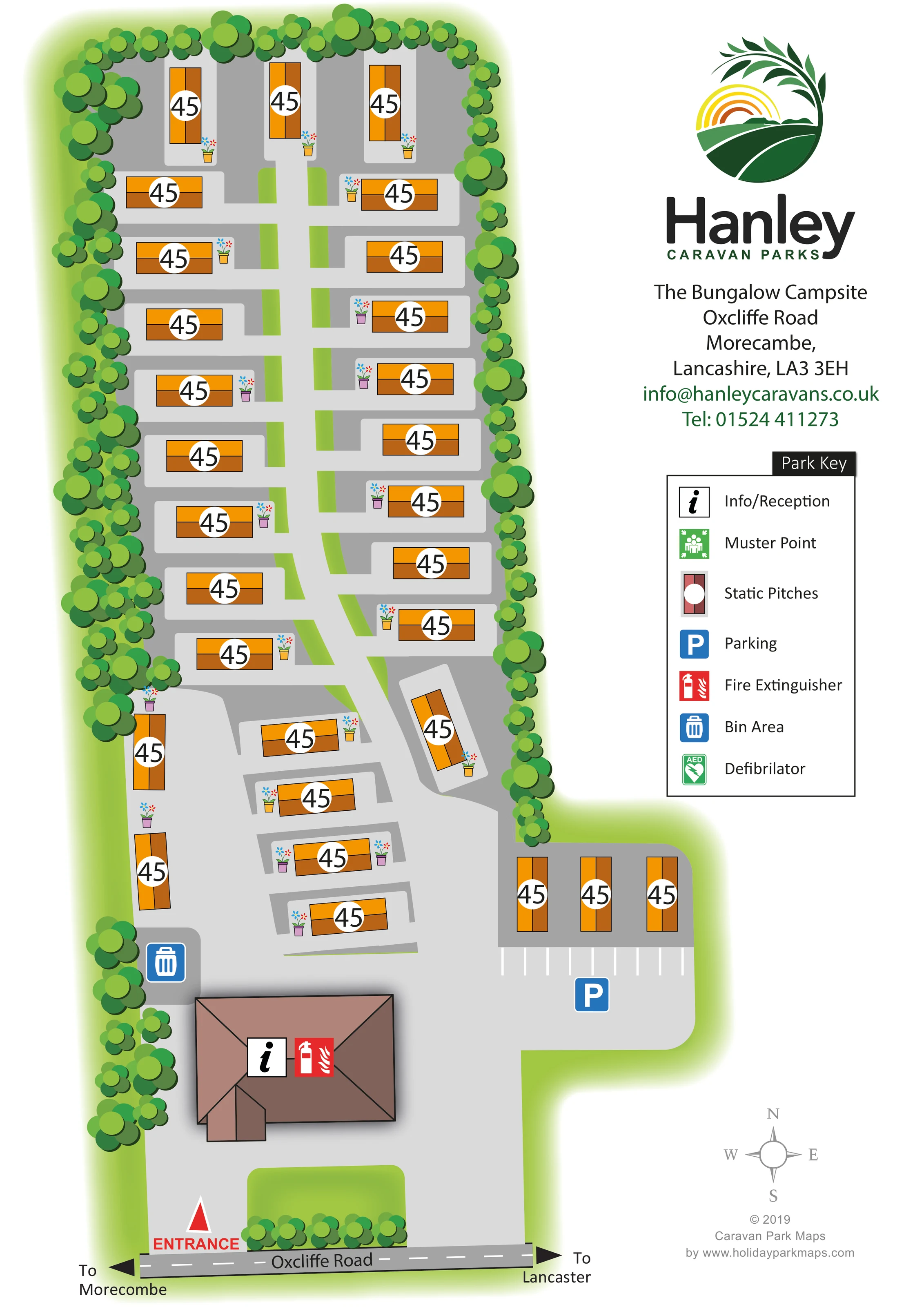
Dense stylised tree planting encloses the long accommodation area and continues around parts of the entrance.
ILLUSTRATED PARK MAP · P617
The Bungalow Campsite, Oxcliffe Road, Morecambe, Lancashire · United Kingdom
 Enlarge the map ↗
A SENSE OF THE PLACE
The Bungalow Leisure Park is located on the outskirts of Morecambe in Lancashire. Its setting combines a quieter park environment with access to the town's promenade and local amenities.
The coast, Lake District and Yorkshire Dales provide wider options for days out. The map shows the accommodation layout and routes within the grounds, helping owners and visitors understand the organisation of the park.
LOOK CLOSER
Dense stylised tree planting encloses the long accommodation area and continues around parts of the entrance.
Narrow green strips divide portions of the pitch layout, with a larger rounded lawn beside the entrance.
An information symbol marks the large roofed building near the entrance.
A blue parking symbol and white bay markings identify parking on the eastern side of the entrance forecourt.
A blue bin symbol marks a small grey area west of the reception building.
A red fire-extinguisher symbol appears on the reception building.
The entrance is labelled in red at the southern edge, directly off Oxcliffe Road.
A pale grey route extends north from the entrance area, with short lateral branches serving the static pitches.
An information symbol marks the large roofed building near the entrance.
A blue parking symbol and white bay markings identify parking on the eastern side of the entrance forecourt.
A blue bin symbol marks a small grey area west of the reception building.
A red fire-extinguisher symbol appears on the reception building.
Included in the Park Key; no corresponding position is clearly marked on the plan.
An AED symbol is explained in the Park Key, without a clearly identifiable location on the plan.
The entrance is labelled in red at the southern edge, directly off Oxcliffe Road.
A pale grey route extends north from the entrance area, with short lateral branches serving the static pitches.
Black arrows at either end of Oxcliffe Road indicate Morecambe to the left and Lancaster to the right.
Dense stylised tree planting encloses the long accommodation area and continues around parts of the entrance.
Narrow green strips divide portions of the pitch layout, with a larger rounded lawn beside the entrance.
A grey four-point compass in the lower-right margin indicates north towards the top of the page.
READING THE MAP
This illustrated map of The Bungalow Leisure Park in Morecambe presents a compact static-caravan site in a clear portrait format. Named The Bungalow Campsite on the artwork, the park is shown extending north from Oxcliffe Road, with a tree-lined accommodation area and a wider arrival space around reception. Roughly 30 caravan symbols give a useful sense of the scale without overwhelming the page.
The design pairs a simple overhead layout with distinctive orange accommodation symbols, pale grey access routes and layered green planting. Short branches off the central route make the arrangement of the pitches easy to understand, while the entrance, reception, parking and bin area provide recognisable arrival landmarks. Direction arrows towards Morecambe and Lancaster connect the internal plan to the surrounding road.
A generous right-hand column carries Hanley Caravan Parks branding, contact information and a boxed key. The result is a small-park mapping example focused on arrival, accommodation organisation and straightforward visitor orientation rather than a large leisure-facility network.
The plan occupies the left side of a portrait page, following the park’s long, narrow footprint. Oxcliffe Road runs across the bottom, with a dashed centre line and arrows towards Morecambe and Lancaster. A red entrance marker leads into a broad grey forecourt. The brown-roofed reception building sits just inside this approach, identified by an information symbol and a red fire-extinguisher icon. A bin area is marked to the west, while parking bays and a blue parking symbol occupy the eastern extension.
Beyond the arrival area, a pale grey central route runs north through the static pitches. Short side branches create a repeated ladder-like arrangement, with caravans placed on both sides. Most accommodation symbols are horizontal, but vertical units close the northern end and line the area above the parking bays. Several lower pitches sit at angles around the changing shape of the access route. Narrow green strips interrupt the grey surfaces and help separate the rows visually.
A dense border of overlapping green tree shapes encloses the accommodation. Small flowerpots beside many units add colour and a domestic touch, while a rounded lawn and planting soften the entrance. Orange-and-brown caravan rectangles stand out against the grey ground, each carrying a prominent white circular label field.
The right-hand column contains the Hanley logo, park address and contact details, followed by the Park Key. The key also includes muster-point and defibrillator symbols, although their positions are not clearly marked within the plan. A compass and designer credit complete the lower margin. The enlarged detail view shows this same legend and parking corner rather than a separate map variant.
KEEP EXPLORING
Chosen for shared landscapes, accommodation or facilities.
 Explore the map ↗
United Kingdom
Coastal park map with static-caravan rows, touring pitches, a camping field and two leisure clusters.
 Explore the map ↗
United Kingdom
A wooded Allerton park plan with colour-coded neighbourhoods, touring pitches and a central facilities hub.
 Explore the map ↗
United Kingdom
Illustrated coastal holiday-home plan with dense alphanumeric plot labels, orange-roofed amenities, a numbered facility key and beach-side context.
Features may come from the sample artwork, its key or published park information. Approximate numbers describe the drawing and may cover only part of a park. They are intended to help you compare map examples. Current facilities and booking information should be checked with the park.
LET’S MAP YOUR PARK
For a map quotation, find your park and draw a rough boundary around it. The area you select helps us work out the design time and price.
Draw your park for a quote ↗Or talk to our map designers
01751 473136