
Woodland setting
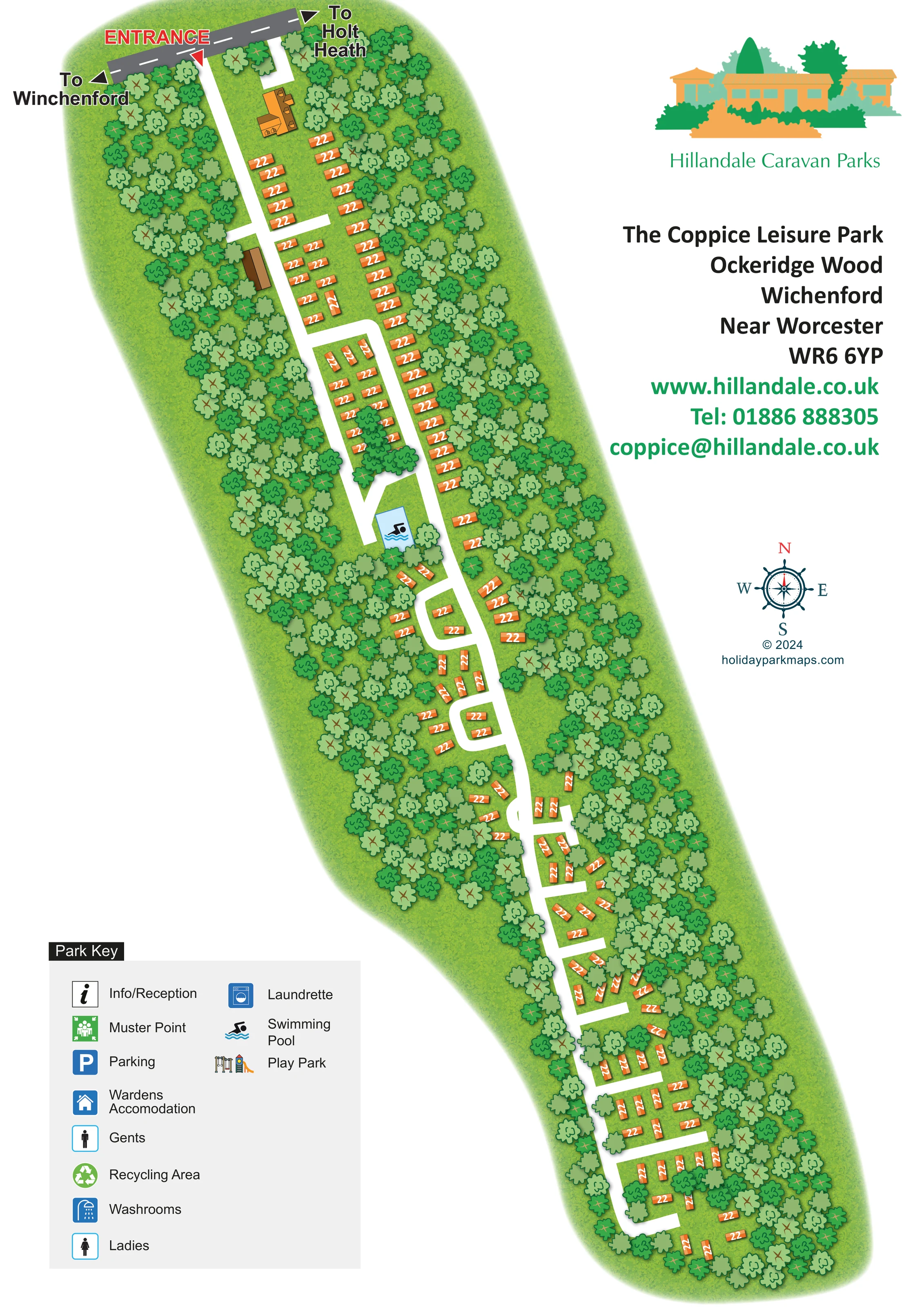
Dense illustrated trees surround the site and extend between accommodation groups, forming the dominant visual character.
ILLUSTRATED PARK MAP · P329
The Coppice Leisure Park, Ockeridge Wood, Wichenford, Near Worcester · United Kingdom
 Enlarge the map ↗
A SENSE OF THE PLACE
The Coppice Leisure Park is a holiday home park at Ockeridge Wood near Worcester. Woodland surrounds the park, and homes are arranged in smaller groups among the trees.
Forest walks and nature trails are part of its appeal. Children's adventure play, a football pitch and a basketball court provide outdoor recreation, while the map connects the accommodation areas with the shared spaces.
LOOK CLOSER
Dense illustrated trees surround the site and extend between accommodation groups, forming the dominant visual character.
Textured yellow-green ground connects the homes, roads and woodland margins.
A prominent red ENTRANCE label and triangular marker identify the northern connection to the external road.
Arrowheads at either end of the grey external road indicate the two destinations. The map's western direction label spells Wichenford as 'Winchenford'.
A long white spine road serves short perpendicular branches, compact loops and terminal accommodation pockets.
A pale-blue rectangular pool with a swimmer symbol is positioned beside the internal road in the upper-middle part of the site.
Dense illustrated trees surround the site and extend between accommodation groups, forming the dominant visual character.
Textured yellow-green ground connects the homes, roads and woodland margins.
A prominent red ENTRANCE label and triangular marker identify the northern connection to the external road.
Arrowheads at either end of the grey external road indicate the two destinations. The map's western direction label spells Wichenford as 'Winchenford'.
A long white spine road serves short perpendicular branches, compact loops and terminal accommodation pockets.
A pale-blue rectangular pool with a swimmer symbol is positioned beside the internal road in the upper-middle part of the site.
An information symbol appears in the Park Key; a corresponding position is not clearly marked on the plan.
A green assembly-point symbol is included in the key without a clearly identifiable location on the plan.
A blue P symbol is defined in the key; a specific parking area is not clearly identified in the illustrated site.
A blue house symbol is listed in the key. The larger buildings near the entrance are not visibly assigned this symbol.
The key includes separate ladies, gents and washroom symbols, but their positions are not clearly marked.
A green recycling symbol appears in the key without a clearly identifiable mapped location.
A blue washing-machine symbol appears in the key; no corresponding location is clearly visible on the plan.
An illustrated swing and slide symbol is included in the key, but a play area is not clearly positioned on the plan.
Published park information describes forest walks and nature trails. These are wider park context rather than separately marked walking routes in this artwork.
Published park information names these outdoor recreation facilities. The football pitch and basketball court are not visibly mapped, while play provision is represented only in the key.
READING THE MAP
This illustrated map of The Coppice Leisure Park places its woodland setting at the centre of the design. Located at Ockeridge Wood, Wichenford, near Worcester, the holiday-home park is shown as a long, narrow site surrounded by trees, with accommodation gathered into clearings along a single main road. Orange home symbols stand out against layered greens, while broad white roads make the route through the park easy to follow.
The entrance sits at the upper end of the plan, beside a grey road carrying directions towards Wichenford and Holt Heath. Farther into the site, short branches and small loops connect the accommodation groups, and a pale-blue swimming pool provides a recognisable landmark. The portrait composition uses the white space alongside the diagonal plan for Hillandale Caravan Parks branding, the park address, contact details and a compass.
For a sample gallery, this is a useful example of mapping a wooded holiday-home park without losing the distinction between its access network and its landscape. The trees communicate the setting, while the contrasting roads and accommodation keep the overall arrangement readable.
The plan extends diagonally from the entrance at the upper left to a rounded, tree-enclosed end at the lower right. A grey external road crosses the northern tip, with directional arrows towards Wichenford and Holt Heath. The red entrance label identifies the junction with the park's white internal road, which forms the main organising line through the artwork.
Near the entrance, the orange holiday-home symbols are arranged in comparatively long rows. Farther down, short perpendicular roads and compact loops create smaller groups on either side of the spine. Trees occupy both the outer margins and spaces between these groups, giving the accommodation a series of wooded settings rather than the appearance of one uninterrupted grid. The depiction is on the scale of roughly 150 holiday homes, represented consistently rather than divided into separate accommodation classes.
A pale-blue swimming pool with a black swimmer symbol stands beside a branch of the internal road in the upper-middle section. Two larger illustrated buildings near the northern end offer additional landmarks, although their functions are not labelled. The lower-left Park Key lists reception, a muster point, parking, wardens' accommodation, toilets, washrooms, recycling, a laundrette, a swimming pool and a play park. Apart from the pool, these symbols do not have clearly identifiable positions on the plan.
The upper-right branding and address block, compass and lower-left key complete a single portrait composition. Detail views enlarge the same key and southern accommodation area; they are not additional maps or separate park sections. Varied tree shapes, subtle shadows and a softly fading grass boundary give the otherwise straightforward plan its distinctive illustrated finish.
KEEP EXPLORING
Chosen for shared landscapes, accommodation or facilities.
 Explore the map ↗
United Kingdom
A colour-zoned coastal park map with touring areas, woodland trails, ponds and a leisure club.
 Explore the map ↗
United Kingdom
Woodland-edged caravan and touring park plan with colourful plots, clear arrivals information and a dedicated health-club panel.
 Explore the map ↗
United Kingdom
Woodland caravan-park map with coastal context, Cloch Lighthouse and clearly marked visitor facilities.
Features may come from the sample artwork, its key or published park information. Approximate numbers describe the drawing and may cover only part of a park. They are intended to help you compare map examples. Current facilities and booking information should be checked with the park.
LET’S MAP YOUR PARK
For a map quotation, find your park and draw a rough boundary around it. The area you select helps us work out the design time and price.
Draw your park for a quote ↗Or talk to our map designers
01751 473136