
Hedge-divided pitches and tree-lined boundaries
Dense illustrated trees define the outer boundary, while lower hedges divide individual pitches and accommodation groups.
ILLUSTRATED PARK MAP · P347
Gorran, St Austell, Cornwall · United Kingdom
 Enlarge the map ↗
A SENSE OF THE PLACE
Tregarton Park is based at Gorran, St Austell, Cornwall. Tregarton is a family-run touring and camping park near Mevagissey on Cornwall's south coast. Pitches are separated by hedging and shrubs; all include electric hook-ups and some have gravel hardstanding.
An outdoor heated pool is available seasonally to guests staying at the park. The park describes a 12-acre setting near Gorran Haven and Mevagissey.
LOOK CLOSER
Dense illustrated trees define the outer boundary, while lower hedges divide individual pitches and accommodation groups.
An information symbol marks a small blue-roofed building at the southern end of the central facilities cluster.
A shopping-trolley symbol identifies the long central building beside the pool terrace.
A bright blue rectangular pool occupies a cream-coloured terrace with illustrated seating and parasols beside the main facilities.
Picnic-table silhouettes sit beside the shop building, with additional parasol seating along the pool terrace.
A washing-machine symbol marks a separate blue-roofed building north of the shop and pool.
Toilet and baby-changing symbols identify a shared facilities building within the central service cluster.
A wheelchair symbol appears alongside reception/information. The key names this category without specifying individual adaptations.
An information symbol marks a small blue-roofed building at the southern end of the central facilities cluster.
A shopping-trolley symbol identifies the long central building beside the pool terrace.
A bright blue rectangular pool occupies a cream-coloured terrace with illustrated seating and parasols beside the main facilities.
Picnic-table silhouettes sit beside the shop building, with additional parasol seating along the pool terrace.
A washing-machine symbol marks a separate blue-roofed building north of the shop and pool.
Toilet and baby-changing symbols identify a shared facilities building within the central service cluster.
A wheelchair symbol appears alongside reception/information. The key names this category without specifying individual adaptations.
A green court with white tennis markings and an orange-edged enclosure forms a prominent landmark near the entrance.
An orange-fenced grassy enclosure contains illustrated swings, a climbing structure with slide and a seesaw in the lower-right part of the park.
A large hedge-enclosed area in the upper-left corner is identified by a dog silhouette and scattered paw prints.
A dog-waste-bin symbol is positioned beside the route into the dog area.
Repeated blue tap symbols mark shared water points among pitch rows, around the perimeter and near the tennis court.
A blue disposal symbol is placed immediately beside the tennis court.
Dense illustrated trees define the outer boundary, while lower hedges divide individual pitches and accommodation groups.
A wooden entrance sign marks access from the grey road along the eastern edge. Directional arrows name St Austell and Gorran.
Broad white routes create linked loops around the pitch groups and connect them to the central amenities and northern buildings.
Red-ringed 10 symbols are repeated at several internal junctions and explained in the symbols key.
A blue-roofed building on the northern approach is labelled 'Tragarton Cottage'. Its use as visitor accommodation is not established by the artwork.
Included in the symbols key; no corresponding position is clearly identifiable on the main plan.
A fire-point symbol is explained in the key, without a clearly identifiable mapped location.
A parking symbol appears in the key; a parking area is not clearly located by that symbol on the plan.
A green assembly symbol is included in the key, but its position is not clearly shown.
An AED symbol is included in the key, without a clearly identifiable location on the map.
A telephone symbol is explained in the key but is not clearly positioned on the main plan.
The symbols key includes a no-entry sign; no matching sign is clearly identifiable on the main plan.
READING THE MAP
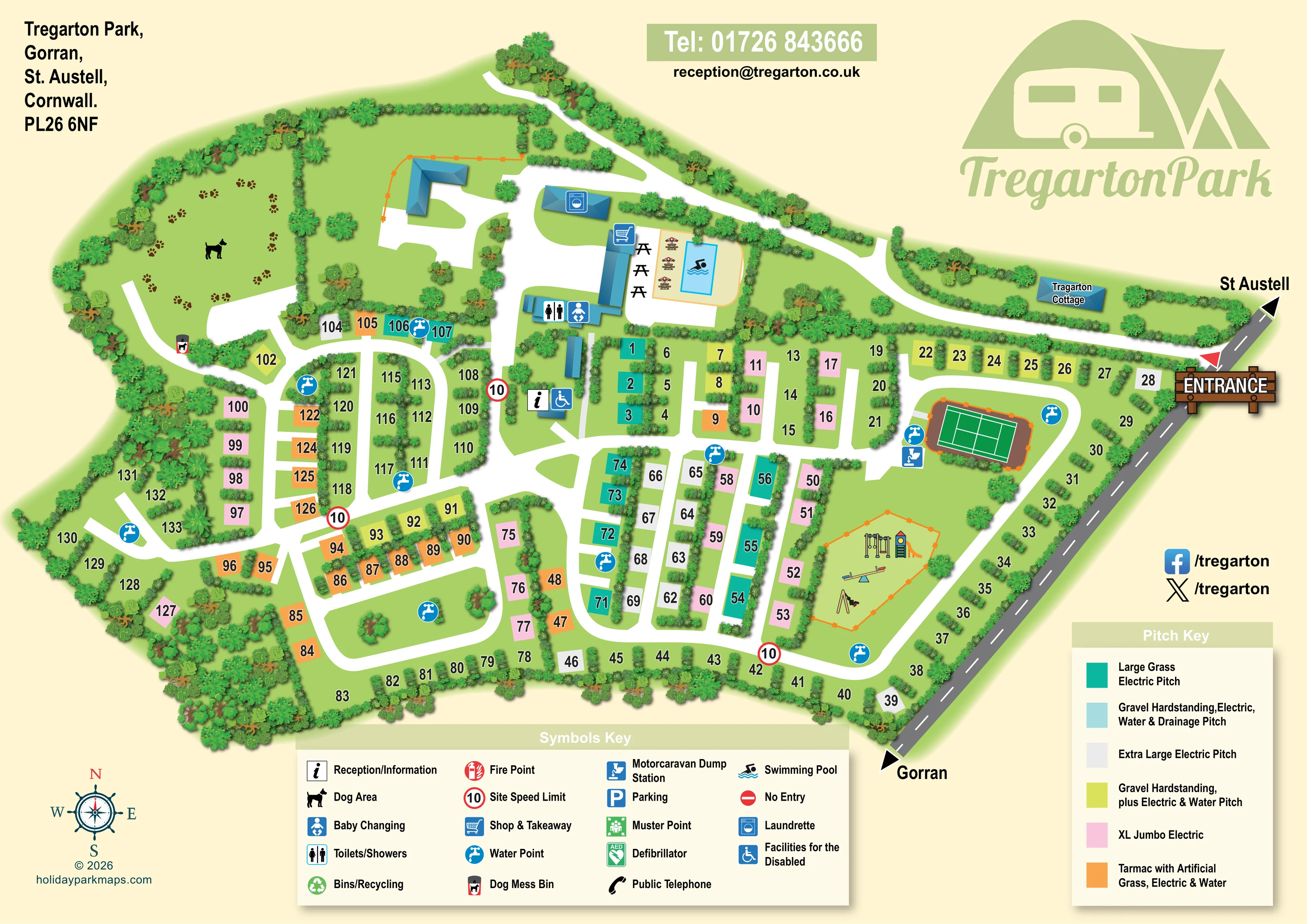
This illustrated map of Tregarton Park in Gorran, Cornwall, brings a hedge-divided touring and camping site into one clear visitor plan. Rather than filling the park with caravan and tent drawings, the artwork uses numbered pitches, selected colour fills and a dedicated pitch key to explain the different sizes, surfaces and service combinations. Broad white lanes make the internal layout easy to follow against the green grounds.
The entrance is picked out beside the road towards St Austell and Gorran, with the tennis court providing an immediate landmark. Further into the park, blue-roofed buildings gather reception, everyday facilities, the shop and takeaway, and the pool area into a recognisable central cluster. A separate dog area, an illustrated playground and repeated water-point symbols add practical detail without overwhelming the pitch layout.
Dense trees and individual hedge divisions give the map its distinctive character. The cream background, sage-green branding and separate lower legends balance that landscape detail with the information visitors need to find their pitch and orient themselves.
The single-page plan places the park entrance on the eastern boundary, where a wooden sign meets a grey road labelled towards St Austell and Gorran. Inside the park, broad white lanes form linked loops around numbered pitch groups. Some pitches follow the outer boundary, while others sit in short parallel rows divided by illustrated hedges. A six-colour pitch key distinguishes grass electric pitches, larger electric options and several hardstanding specifications, including water, drainage and artificial-grass combinations.
The main amenities sit towards the upper centre. Reception/information and a wheelchair symbol mark the southern end of this cluster, with toilets, showers and baby changing nearby. Separate symbols identify the laundrette and the shop and takeaway. Beside the shop, a bright blue pool sits within a pale terrace illustrated with parasols and seating; picnic tables line the neighbouring building.
A tennis court stands close to the entrance, with the motorcaravan dump-station symbol alongside it. Further south, an orange-fenced play area contains swings, a seesaw and a climbing structure with a slide. At the opposite side of the park, the dog area is enclosed by planting and decorated with paw prints, with a dog-waste bin beside its access route. Blue water-point symbols recur throughout the pitch layout. The northern lane also passes a building labelled 'Tragarton Cottage'.
The lower symbols panel explains facilities and traffic symbols, while the separate pitch panel handles accommodation specifications. Some symbols, including parking, the defibrillator and public telephone, appear in the key without a clearly marked position on the plan. The accompanying close-up views enlarge these same legends rather than showing additional park sections.
KEEP EXPLORING
Chosen for shared landscapes, accommodation or facilities.
 Explore the map ↗
United Kingdom
Coastal park map with static-caravan rows, touring pitches, a camping field and two leisure clusters.
 Explore the map ↗
United Kingdom
A colour-zoned coastal park map with touring areas, woodland trails, ponds and a leisure club.
 Explore the map ↗
United Kingdom
Colour-coded accommodation, central leisure facilities and coastal paths on an illustrated headland park map.
Features may come from the sample artwork, its key or published park information. Approximate numbers describe the drawing and may cover only part of a park. They are intended to help you compare map examples. Current facilities and booking information should be checked with the park.
LET’S MAP YOUR PARK
For a map quotation, find your park and draw a rough boundary around it. The area you select helps us work out the design time and price.
Draw your park for a quote ↗Or talk to our map designers
01751 473136