
Adjacent public play area
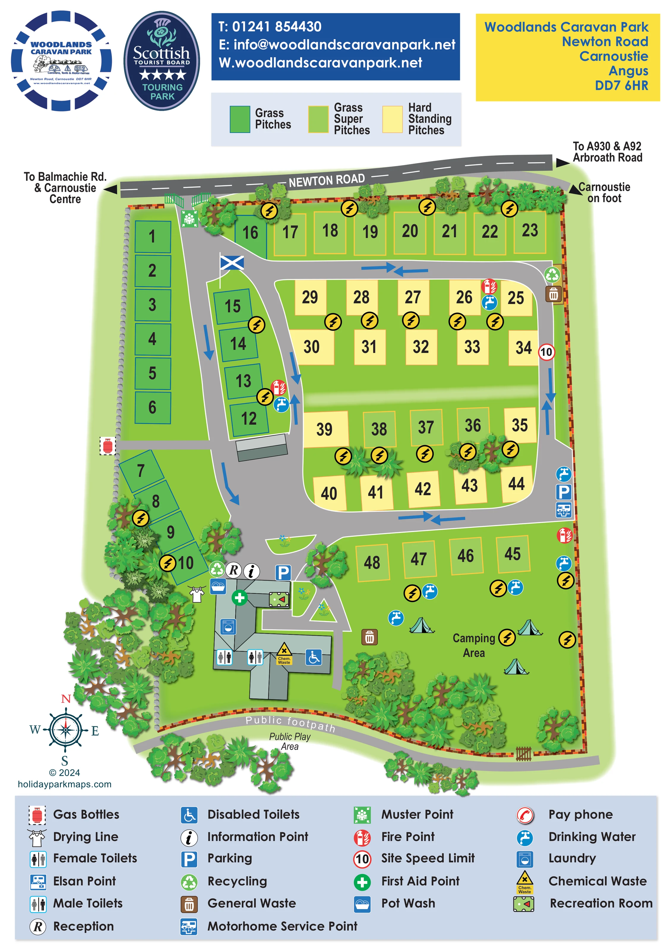
Public Play Area is labelled outside the park, beyond the southern footpath. It is not depicted as an internal park facility.
ILLUSTRATED PARK MAP · P375
Newton Road, Carnoustie, Angus · United Kingdom
 Enlarge the map ↗
A SENSE OF THE PLACE
Woodlands Caravan Park offers adults-only touring in Carnoustie, close to the beach, town amenities and golf course. Caravans, motorhomes and campervans are welcomed.
Pitches include electric connections, with water and drainage on the super pitches. Heated washrooms, accessible toilets, laundry and a recreation room with pool table and television support stays, and dogs are accepted.
LOOK CLOSER
Public Play Area is labelled outside the park, beyond the southern footpath. It is not depicted as an internal park facility.
Dense illustrated trees frame the western and southern edges, with smaller clusters between pitches. Stonework marks the west boundary and warm-coloured brickwork marks much of the remaining perimeter.
The upper key distinguishes Grass Pitches, Grass Super Pitches and Hard Standing Pitches, with corresponding colours used throughout the plan.
Yellow circles with black lightning bolts appear beside touring pitch groups and within the camping area.
Reception and information symbols identify the northern side of the main service building in the south-west.
Male, female and wheelchair-symbol toilet facilities are marked along the southern wing of the service building.
A washing-machine symbol marks the laundry within the service building, with a drying-line illustration immediately to its west.
A dishwashing symbol is positioned beside the reception end of the service building.
The upper key distinguishes Grass Pitches, Grass Super Pitches and Hard Standing Pitches, with corresponding colours used throughout the plan.
Yellow circles with black lightning bolts appear beside touring pitch groups and within the camping area.
Reception and information symbols identify the northern side of the main service building in the south-west.
Male, female and wheelchair-symbol toilet facilities are marked along the southern wing of the service building.
A washing-machine symbol marks the laundry within the service building, with a drying-line illustration immediately to its west.
A dishwashing symbol is positioned beside the reception end of the service building.
A pool-table pictogram identifies the recreation room in the eastern arm of the main building.
Blue tap symbols are distributed beside touring rows, along the eastern road and around the camping area.
A motorhome service symbol is placed beside parking and water facilities on the eastern side of the internal road.
A yellow warning-style chemical waste symbol marks the southern part of the service building.
An Elsan point is included in the legend; its separate location is not clearly identifiable on the plan.
Parking symbols appear beside reception and along the eastern service road.
Recycling and waste symbols are grouped at several service locations, including near reception, the north-eastern road bend and the camping lawn.
A gas-cylinder symbol marks a point beside the western boundary, reached by a short spur from the internal road.
Fire points are distributed around the pitch roads, first aid is marked at the service building, and a muster point appears just inside the entrance.
A red-bordered circular symbol displaying 10 is shown on the eastern road and explained in the legend. No unit is printed.
The legend includes a pay-phone symbol, without a clearly identifiable position on the main plan.
The gated entrance opens from Newton Road at the north-west. Road arrows point towards Balmachie Road and Carnoustie Centre to the left, and the A930, A92 and Arbroath Road to the right.
A western arrival spine connects with a rounded loop around the central pitch blocks. Blue arrows indicate travel directions, including opposing arrows on several stretches.
A labelled public footpath follows the southern boundary, with a small gate shown near the south-east. A separate arrow near Newton Road points towards Carnoustie on foot.
Public Play Area is labelled outside the park, beyond the southern footpath. It is not depicted as an internal park facility.
Dense illustrated trees frame the western and southern edges, with smaller clusters between pitches. Stonework marks the west boundary and warm-coloured brickwork marks much of the remaining perimeter.
READING THE MAP
This illustrated map of Woodlands Caravan Park in Carnoustie, Angus, brings a compact touring layout into a single portrait-format visitor guide. Newton Road runs across the top of the plan, with the entrance opening into a network of grey roads, numbered pitches and clearly marked service points. Trees frame much of the site, while a public footpath follows the southern boundary and an adjacent public play area provides useful local context.
The map’s main organising device is its three-colour pitch system: grass, grass super and hard-standing pitches are immediately distinguishable without drawing individual caravans. Large numbers remain prominent, and yellow electricity symbols stand out against the green grounds. An open camping area occupies the lower-right corner, opposite the reception and service building.
For a touring-park map, the practical detail is particularly useful. Water, waste, parking, laundry, toilets and motorhome servicing are integrated into the plan, with a substantial legend below. The result is a sample suited to operators who need to explain pitch choice, arrival routes and everyday facilities within a modest, landscaped site.
The plan is arranged around an entrance from Newton Road at the upper-left corner. A broad road descends through the western side of the park towards reception, while connecting roads form a rounded loop around the central touring rows. Blue directional arrows make circulation visible, and external arrows identify routes towards Carnoustie Centre, Balmachie Road, Arbroath Road and the A930 and A92. A separate pedestrian direction points towards Carnoustie on foot.
Numbered grass pitches line the western boundary and the arrival road. Grass super pitches occupy the northern row and a short row above the camping area, with a further small group within the central arrangement. Pale yellow hard-standing pitches form most of the paired central rows. Their simple rectangular shapes and large black numbers contrast with the more elaborate trees planted around the perimeter and between selected groups.
The south-western service building is drawn as an irregular collection of grey-green roof planes. Symbols locate reception, information, pot wash, laundry, first aid, the recreation room, male and female toilets, an accessible toilet and chemical waste. Nearby are parking, recycling and a drying line. Additional water, fire and waste points are spread through the site, and a motorhome service point sits beside the eastern road.
The south-eastern camping lawn is labelled directly and illustrated with small tents. Along the lower edge, a public footpath curves outside the brick boundary, with a gate near the eastern end and a public play-area label beyond it. A compass rose, upper pitch-colour key and full-width lower facility legend complete the page. The enlarged detail views show portions of this same portrait artwork rather than separate park sections.
KEEP EXPLORING
Chosen for shared landscapes, accommodation or facilities.
 Explore the map ↗
United Kingdom
Coastal park map with static-caravan rows, touring pitches, a camping field and two leisure clusters.
 Explore the map ↗
United Kingdom
A wooded Allerton park plan with colour-coded neighbourhoods, touring pitches and a central facilities hub.
 Explore the map ↗
United Kingdom
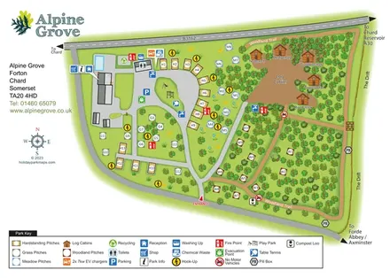
Colour-coded pitches, named log cabins and a woodland trail at Alpine Grove, Somerset.
Features may come from the sample artwork, its key or published park information. Approximate numbers describe the drawing and may cover only part of a park. They are intended to help you compare map examples. Current facilities and booking information should be checked with the park.
TAKE A CLOSER LOOK
View the illustrated map in detail or choose a file to download. These are sample maps; contact the park for current visitor information.
LET’S MAP YOUR PARK
For a map quotation, find your park and draw a rough boundary around it. The area you select helps us work out the design time and price.
Draw your park for a quote ↗Or talk to our map designers
01751 473136