
Named lakes and pond
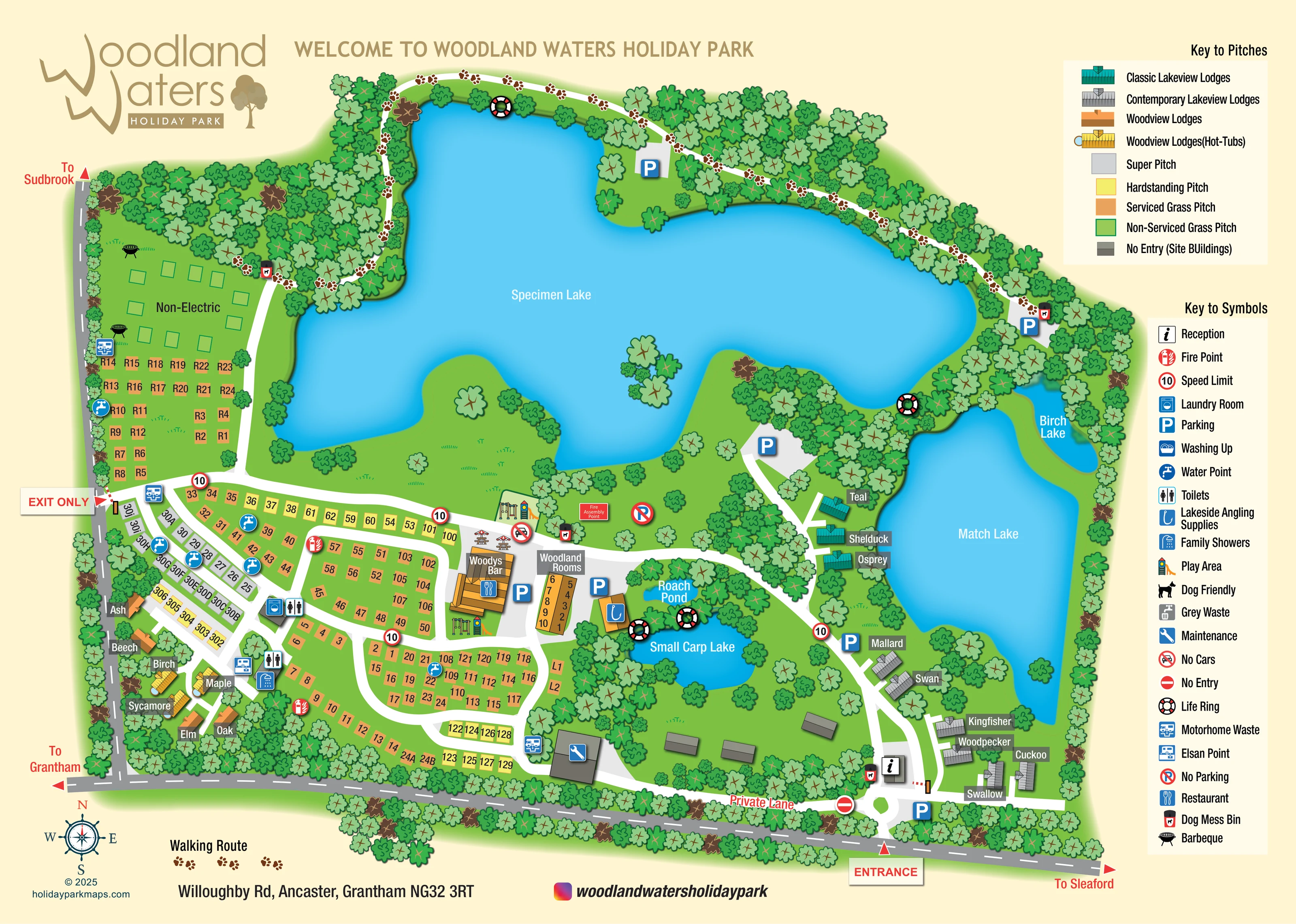
Specimen Lake dominates the upper plan, Match Lake occupies the east, Birch Lake sits beside it, and Small Carp Lake and Roach Pond lie near the central facilities.
ILLUSTRATED PARK MAP · P374
Willoughby Road, Ancaster, Grantham · United Kingdom
 Enlarge the map ↗
A SENSE OF THE PLACE
Woodland Waters is a fishing and holiday park in a wooded valley at Ancaster in Lincolnshire. Lakes form a central part of the grounds, with lodges and touring accommodation overlooking the landscape.
Touring facilities include washrooms, laundry and accessible provision. Picnic areas, children's play and woodland paths provide ways to enjoy the surroundings, while the map connects the accommodation areas and fishing lakes.
LOOK CLOSER
Specimen Lake dominates the upper plan, Match Lake occupies the east, Birch Lake sits beside it, and Small Carp Lake and Roach Pond lie near the central facilities.
Dense illustrated trees enclose much of the site and line the water, with wooded peninsulas, small islands and scattered trees between accommodation areas.
A white path marked with brown paw prints follows the northern woodland and the upper edge of Specimen Lake, linking towards the western grass area and eastern lakeside parking.
An information symbol identifies reception just inside the main entrance at the south-east.
A prominent illustrated building labelled Woodys Bar carries the restaurant symbol, with outdoor tables immediately beside it.
Play equipment is depicted beside the central bar area and again along its southern edge.
The angling-supplies symbol marks a small building between Woodland Rooms and the small fishing waters.
Toilet and family-shower symbols identify service buildings within the south-western accommodation area.
Specimen Lake dominates the upper plan, Match Lake occupies the east, Birch Lake sits beside it, and Small Carp Lake and Roach Pond lie near the central facilities.
Dense illustrated trees enclose much of the site and line the water, with wooded peninsulas, small islands and scattered trees between accommodation areas.
A white path marked with brown paw prints follows the northern woodland and the upper edge of Specimen Lake, linking towards the western grass area and eastern lakeside parking.
An information symbol identifies reception just inside the main entrance at the south-east.
A prominent illustrated building labelled Woodys Bar carries the restaurant symbol, with outdoor tables immediately beside it.
Play equipment is depicted beside the central bar area and again along its southern edge.
The angling-supplies symbol marks a small building between Woodland Rooms and the small fishing waters.
Toilet and family-shower symbols identify service buildings within the south-western accommodation area.
A laundry symbol is attached to a service block among the western pitches.
Repeated blue tap symbols are distributed among the western and southern pitch groups.
Disposal symbols appear at several locations around the touring area, including near the western exit and southern service buildings.
Listed in the symbol key; a distinct location is not clearly established in the artwork.
Included in the symbol key without a clearly identifiable separate grey-waste marker on the plan.
Parking symbols mark the entrance, central buildings, lakeview accommodation and several points beside the larger lakes.
Black barbecue illustrations appear in the north-western Non-Electric area.
Bin symbols are positioned along the woodland route, near central facilities and by reception.
The key includes a Dog Friendly symbol, but it does not establish a particular mapped location or a park-wide pet policy.
Fire points are dispersed around the accommodation areas, a Fire Assembly Point is labelled near the central play area, and life rings mark several lake edges.
A maintenance symbol marks a southern building; muted grey structures represent site buildings identified in the pitch key as no-entry areas.
The south-eastern entrance leads from Willoughby Road to reception. A separate western opening is labelled Exit Only; road arrows indicate Grantham, Sleaford and Sudbrook.
The artwork includes speed-limit signs, no-parking and no-cars markers, an entrance barrier and a no-entry marker beside the labelled Private Lane.
The park information describes accessible touring provision; the map does not identify a separate accessible facility symbol.
READING THE MAP
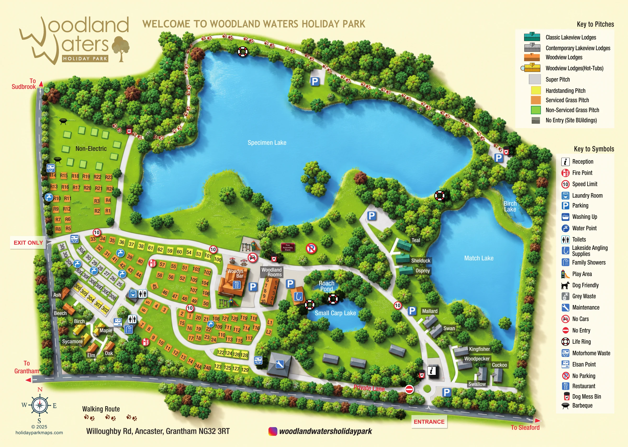
Lakes and woodland give this Woodland Waters map its structure. Created for the holiday and fishing park at Ancaster in Lincolnshire, the illustrated plan places the expansive Specimen Lake across the upper half of the page, with Match Lake and Birch Lake to the east and two smaller waters near the central facilities. The result is a map that explains the setting as well as the accommodation layout.
Colour-coded touring pitches occupy the western and southern areas, while individually drawn lodges sit beside the lakes or among the trees. Their bird and tree names provide memorable landmarks alongside the numbered pitches. Woodys Bar, Woodland Rooms, reception, play areas and touring services are picked out with building illustrations and familiar symbols.
A paw-print walking route traces the northern woodland, adding a recreational layer distinct from the internal access roads. Separate pitch and facility keys help visitors interpret a fairly detailed site without losing the overall picture. This sample is particularly relevant to parks where fishing waters, several accommodation types and dispersed services all need to appear on one visitor-facing plan.
The single landscape-format plan presents Woodland Waters as a wooded site organised around five named waters. Specimen Lake dominates the north, with an irregular shoreline, wooded projections and small islands. Match Lake extends down the eastern side, beside Birch Lake, while Roach Pond and Small Carp Lake sit closer to the central buildings. Dense tree belts frame the boundaries and separate many of the accommodation groups.
The main entrance is marked on Willoughby Road at the south-east, next to reception and parking. White internal routes run past the lakeview lodges and towards the central hub, then branch through the western and southern pitch areas. A separate western access is labelled Exit Only. External arrows point towards Grantham, Sleaford and Sudbrook, and a Private Lane label distinguishes another route at the southern edge.
The accommodation key separates super, hardstanding, serviced grass and non-serviced grass pitches, alongside four lodge categories. Teal Classic Lakeview and grey Contemporary Lakeview lodges follow the eastern waterside; orange Woodview lodges and golden hot-tub variants sit in the south-west. Named lodge labels complement the numbered pitch blocks and Woodland Rooms accommodation.
Woodys Bar is illustrated beside outdoor tables and play equipment. Nearby symbols locate angling supplies, parking and the fire assembly point. Toilets, family showers, laundry, water points and waste-disposal provision are shown within the touring areas, with life rings placed beside the lakes. A brown paw-print trail follows the northern woodland, separate from the vehicle routes. The right-hand legends explain the accommodation colours and visitor symbols, while the lower margin carries the compass, address and branding. The enlarged detail views show these same legend and lakeside elements rather than separate map variants.
 Enlarge this map ↗
KEEP EXPLORING
Chosen for shared landscapes, accommodation or facilities.
 Explore the map ↗
United Kingdom
Woodland camping, lodges, lakes and colour-coded bike trails at Avon Tyrrell Outdoor Centre.
 Explore the map ↗
United States
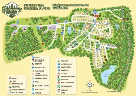
Woodland RV campground map with mixed camping, three water landmarks and a central recreation hub.
 Explore the map ↗
United Kingdom
A lakeside holiday-park and fishery map with numbered accommodation, fishing positions and clearly grouped visitor services.
Features may come from the sample artwork, its key or published park information. Approximate numbers describe the drawing and may cover only part of a park. They are intended to help you compare map examples. Current facilities and booking information should be checked with the park.
LET’S MAP YOUR PARK
For a map quotation, find your park and draw a rough boundary around it. The area you select helps us work out the design time and price.
Draw your park for a quote ↗Or talk to our map designers
01751 473136