
Wooded perimeter
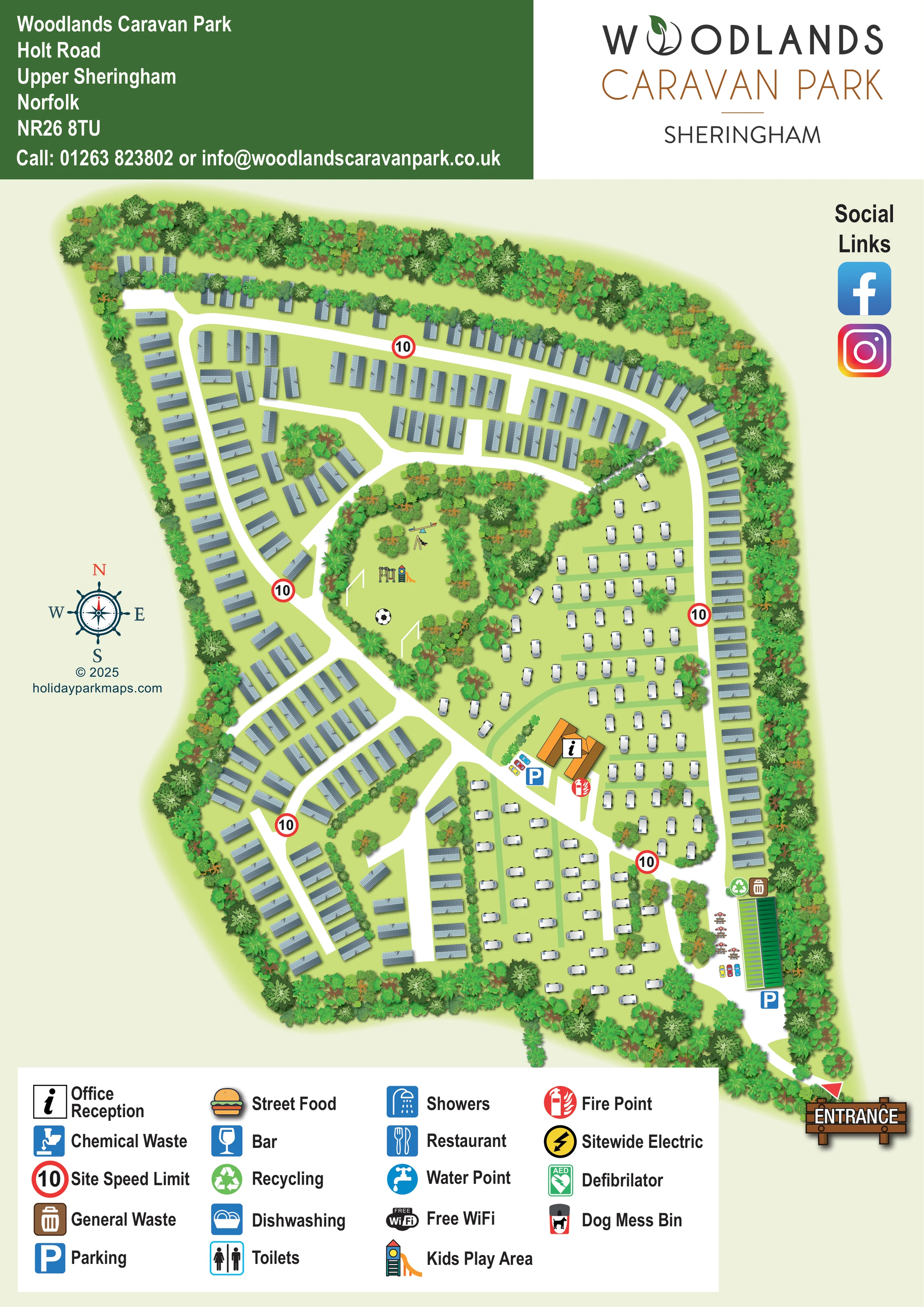
A dense belt of overlapping tree and shrub illustrations encloses almost the entire park.
ILLUSTRATED PARK MAP · P376
Woodlands Caravan Park, Holt Road, Upper Sheringham, Norfolk · United Kingdom
 Enlarge the map ↗
A SENSE OF THE PLACE
Woodlands Caravan Park is a family-owned touring and holiday home park at Upper Sheringham in North Norfolk. It borders Sheringham Park and has access to woodland walks and the nearby coast.
Caravans, motorhomes and campervans are welcomed, with holiday homes also offered for ownership. Bars provide social space on the park; the operator's fishing lakes are at the separate Bodham location. Bus services connect the area with Holt, Sheringham and Cromer.
LOOK CLOSER
A dense belt of overlapping tree and shrub illustrations encloses almost the entire park.
Tree islands, narrow hedge lines and extensive pale-green grass divide the accommodation areas and frame the central recreation clearing.
An information symbol identifies the orange-roofed building beside a central road junction, between the two main touring areas.
Blue parking symbols and small illustrated cars mark parking beside reception and beside the long green-roofed building near the entrance.
A tree-framed central clearing contains illustrated swings, a seesaw and a climbing frame with a slide.
Two white goal frames and a football symbol indicate a grass recreation space beside the play equipment.
Several picnic-style tables with parasols are drawn beside the long building near the entrance; its specific function is not labelled on the plan.
General waste and recycling symbols are positioned together at the northern end of the long entrance-side building.
An information symbol identifies the orange-roofed building beside a central road junction, between the two main touring areas.
Blue parking symbols and small illustrated cars mark parking beside reception and beside the long green-roofed building near the entrance.
A tree-framed central clearing contains illustrated swings, a seesaw and a climbing frame with a slide.
Two white goal frames and a football symbol indicate a grass recreation space beside the play equipment.
Several picnic-style tables with parasols are drawn beside the long building near the entrance; its specific function is not labelled on the plan.
General waste and recycling symbols are positioned together at the northern end of the long entrance-side building.
A red fire-point symbol is placed beside the reception building.
A wooden-style ENTRANCE sign and red arrow identify the approach at the lower-right corner of the illustration.
Broad white roads lead from the entrance to reception, continue around the perimeter and branch into the accommodation rows.
Repeated red-bordered signs marked 10 are positioned along the internal roads and explained in the legend.
A dense belt of overlapping tree and shrub illustrations encloses almost the entire park.
Tree islands, narrow hedge lines and extensive pale-green grass divide the accommodation areas and frame the central recreation clearing.
These facilities have separate symbols in the bottom legend, but their locations are not clearly marked within the illustrated plan.
Chemical-waste disposal and water-point symbols appear in the key without clearly identifiable positions on the plan.
The legend includes separate bar, restaurant and street-food entries; it does not clearly assign these functions to a particular illustrated building.
Sitewide electric and free WiFi are stated in the legend rather than mapped to individual positions.
An AED symbol is included in the legend; no clear corresponding location is visible on the plan.
A dog-waste-bin symbol appears in the legend without a clearly identifiable location in the park illustration.
The park information places the site beside Sheringham Park, with access to woodland walks. These walks are not drawn as a route network on this map.
READING THE MAP
This illustrated map of Woodlands Caravan Park at Upper Sheringham presents a large mixed caravan site within a richly drawn woodland boundary. Rows of grey-roofed holiday caravans follow the outer roads, while smaller white touring vehicles occupy the more open grassy areas through the centre and south. The distinction makes the park's accommodation pattern easy to understand without filling the drawing with individual plot labels.
A broad white road network connects the lower-right entrance with reception, parking and the accommodation areas. At the heart of the illustration, a tree-framed clearing contains children's play equipment and football goals, giving visitors a memorable landmark within the extensive layout. The orange reception roof provides another clear point of reference.
The portrait page combines the park's Sheringham branding and contact details with a large facility legend, compass rose and social-media graphics. Layered greens, textured tree canopies and softly shaded caravan symbols give the plan its particular character. It is a useful example of a visitor map that explains both the organisation and the wooded setting of a substantial caravan park.
The single portrait map follows the park's irregular outline, with a dense belt of trees enclosing the accommodation and a narrow entrance approach extending towards the lower-right corner. A wooden-style entrance sign and red arrow establish the starting point. From there, white roads lead past a long green-roofed building, outdoor tables and marked parking before branching towards reception and the wider park.
Reception is shown as an orange-roofed building beside a central junction, with an information symbol, adjacent parking and a red fire-point marker. The surrounding roads connect to the perimeter route and to shorter branches between the caravan rows. Red-bordered signs marked 10 recur along the roads. A decorative compass rose in the left margin supplies orientation without adding more labels to the accommodation areas.
Static caravans are represented by repeated blue-grey roof forms, arranged along the northern and western boundaries and in a long eastern row. Touring accommodation uses smaller white vehicle symbols on grass, with green strips and planting separating the rows. The central recreation clearing contains swings, a seesaw, a climbing frame with slide, two goal frames and a football symbol. Trees around this clearing help distinguish it from the adjoining touring space.
The large lower legend identifies reception, parking, waste, recycling, fire points and children's play, alongside entries for sanitary facilities, water, chemical waste, food and drink, electric provision, WiFi, an AED and dog-waste bins. Not all legend entries have a visible location in the drawing. The header pairs a dark-green address panel with the park logo, while social-media graphics sit to the right of the plan. The enlarged views show details of this same artwork, not additional park sections.
KEEP EXPLORING
Chosen for shared landscapes, accommodation or facilities.
 Explore the map ↗
United Kingdom
A wooded Allerton park plan with colour-coded neighbourhoods, touring pitches and a central facilities hub.
 Explore the map ↗
United Kingdom
Overhead caravan-park map with wooded boundaries, contrasting pitch loops and a large recreation field.
 Explore the map ↗
United Kingdom
A wooded, streamside park map with a linked farm, café, touring and cottage area.
Features may come from the sample artwork, its key or published park information. Approximate numbers describe the drawing and may cover only part of a park. They are intended to help you compare map examples. Current facilities and booking information should be checked with the park.
LET’S MAP YOUR PARK
For a map quotation, find your park and draw a rough boundary around it. The area you select helps us work out the design time and price.
Draw your park for a quote ↗Or talk to our map designers
01751 473136