
Tree-lined boundaries and planted islands
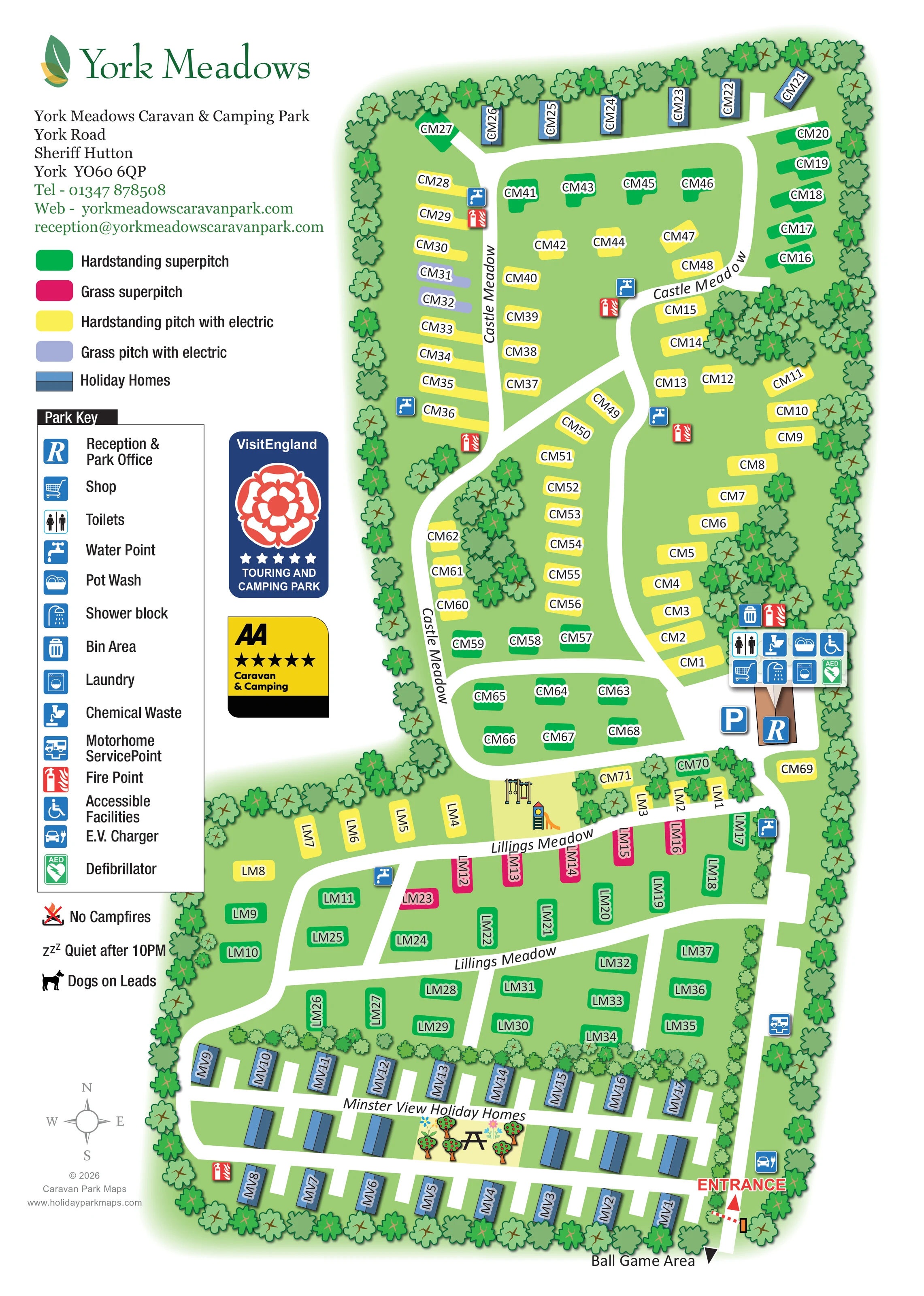
A nearly continuous illustrated tree belt surrounds the park, with additional clumps inside Castle Meadow and a planted division above the southern holiday-home rows.
ILLUSTRATED PARK MAP · P386
York Meadows Caravan & Camping Park, York Road, Sheriff Hutton, York · United Kingdom
 Enlarge the map ↗
A SENSE OF THE PLACE
York Meadows is a family-friendly caravan and camping park at Sheriff Hutton near York. Touring, seasonal pitches and holiday home ownership provide different ways to enjoy the location.
Serviced pitches are supported by family washrooms, accessible facilities and baby-changing provision. Children's outdoor play includes a zip wire, swings and other equipment, with the map helping families find the shared spaces around the park.
LOOK CLOSER
A nearly continuous illustrated tree belt surrounds the park, with additional clumps inside Castle Meadow and a planted division above the southern holiday-home rows.
Green ground unifies the plan, separating pitches, roads, play equipment and holiday homes without a topographic overlay.
An R symbol marks the brown-roofed building on the eastern side, close to the meeting point of Castle Meadow and Lillings Meadow.
A shopping-trolley symbol appears in the shared facilities cluster beside reception.
Separate symbols for toilets, shower block, pot wash and laundry are grouped at the main facilities building.
A wheelchair symbol is included in the main facilities cluster; the map does not describe the detailed provision.
Blue tap symbols are distributed through Castle Meadow and Lillings Meadow, with another at the main facilities.
Bin and chemical-waste symbols identify disposal facilities beside the main service building.
An R symbol marks the brown-roofed building on the eastern side, close to the meeting point of Castle Meadow and Lillings Meadow.
A shopping-trolley symbol appears in the shared facilities cluster beside reception.
Separate symbols for toilets, shower block, pot wash and laundry are grouped at the main facilities building.
A wheelchair symbol is included in the main facilities cluster; the map does not describe the detailed provision.
Blue tap symbols are distributed through Castle Meadow and Lillings Meadow, with another at the main facilities.
Bin and chemical-waste symbols identify disposal facilities beside the main service building.
A motorhome service symbol is placed beside the eastern access road in the lower part of Lillings Meadow.
The electric-vehicle charging symbol is positioned near the entrance at the south-eastern edge.
Red fire-point symbols recur around Castle Meadow, beside the main facilities and in the southern holiday-home area.
A green AED symbol appears in the main facilities cluster.
A blue P symbol marks parking beside reception.
Illustrated swings and a slide occupy a grassy pocket between Castle Meadow and the upper Lillings Meadow pitches.
A picnic table is drawn amongst small fruit-tree and flower illustrations within the Minster View Holiday Homes area.
A labelled arrow at the bottom of the plan points beyond the illustrated boundary towards a ball game area; the area itself is not drawn.
A nearly continuous illustrated tree belt surrounds the park, with additional clumps inside Castle Meadow and a planted division above the southern holiday-home rows.
Green ground unifies the plan, separating pitches, roads, play equipment and holiday homes without a topographic overlay.
Red ENTRANCE lettering and an arrow highlight the access point, accompanied by a small illustrated barrier.
Broad white roads connect the entrance, Minster View, Lillings Meadow and reception before continuing through the looping Castle Meadow layout.
Repeated area names follow the roads and divide the long plan into recognisable visitor destinations.
A grey compass rose in the lower-left margin indicates north towards the top of the page.
Below the key, pictograms accompany the artwork's notices 'No Campfires', 'Quiet after 10PM' and 'Dogs on Leads'. These are recorded as printed map content, not statements of current policy.
The park information describes family washrooms and baby-changing provision, which are not separately identified by the map symbols.
The park information mentions a zip wire and other children's play equipment. The artwork clearly illustrates swings and a slide but does not explicitly label a zip wire.
READING THE MAP
This illustrated map of York Meadows Caravan & Camping Park brings a varied touring and holiday-home layout into one portrait-format visitor guide. Set at Sheriff Hutton near York, the park is presented as a series of green, tree-framed areas connected by broad white roads. Castle Meadow fills the upper part of the plan, Lillings Meadow occupies the middle, and Minster View Holiday Homes forms a more regular arrangement near the southern entrance.
The accommodation key is especially important to this design. Four contrasting colours distinguish hardstanding and grass pitches, including superpitches and pitches with electric, while blue roof illustrations identify holiday homes. Visitors can locate their labelled pitch without losing sight of the wider road network.
Alongside the accommodation, the map shows reception, shared washing facilities, service points, children's play equipment and an illustrated picnic space. A substantial left-hand information column gathers the park branding, contact details, accommodation key and facility symbols. The result is a sample for parks that need to explain several pitch types and accommodation areas within a single, approachable arrival map.
The plan begins at a clearly marked entrance on the south-eastern edge. From here, the eastern road leads past Minster View Holiday Homes and Lillings Meadow towards reception. Minster View is drawn with rows of two-tone blue holiday-home roofs, short access spurs and a small central vignette of fruit trees, flowers and a picnic table. A labelled arrow below the entrance points towards a ball game area beyond the illustrated boundary.
Lillings Meadow has a more open arrangement of coloured pitches divided by cross-roads. Pink grass superpitches form a prominent row beside the upper road, with green and yellow pitches distributed around them. Swings and a slide are illustrated in a grassy pocket between this area and Castle Meadow.
Castle Meadow occupies the largest part of the page. Its sweeping roads enclose internal pitch rows and islands, while further pitches follow the outside edge. Several blue holiday homes sit along its northern boundary. Tree clumps break up the interior, complementing the continuous planted perimeter.
Reception and parking lie on the eastern side near the junction of the two meadows. A compact group of symbols identifies the shop, toilets, showers, pot wash, laundry, accessible facilities and defibrillator. Water and fire points appear around the accommodation areas; chemical waste, bins, a motorhome service point and an entrance-side E.V. charger are also mapped.
The left column combines the accommodation colour key with a larger pictogram legend, visitor notices and rating graphics. Repeated meadow names and individual plot labels support local orientation, while a compass provides overall direction. The accompanying enlarged view repeats the legend and adjoining artwork for readability; it is not a separate park section.
KEEP EXPLORING
Chosen for shared landscapes, accommodation or facilities.
 Explore the map ↗
United Kingdom
Coastal park map with static-caravan rows, touring pitches, a camping field and two leisure clusters.
 Explore the map ↗
United Kingdom
A wooded Allerton park plan with colour-coded neighbourhoods, touring pitches and a central facilities hub.
 Explore the map ↗
United Kingdom
A wooded, mixed-accommodation park plan with winding lanes, a pool, camping areas and a clear facility key.
Features may come from the sample artwork, its key or published park information. Approximate numbers describe the drawing and may cover only part of a park. They are intended to help you compare map examples. Current facilities and booking information should be checked with the park.
TAKE A CLOSER LOOK
View the illustrated map in detail or choose a file to download. These are sample maps; contact the park for current visitor information.

LET’S MAP YOUR PARK
For a map quotation, find your park and draw a rough boundary around it. The area you select helps us work out the design time and price.
Draw your park for a quote ↗Or talk to our map designers
01751 473136