
Quarry wall
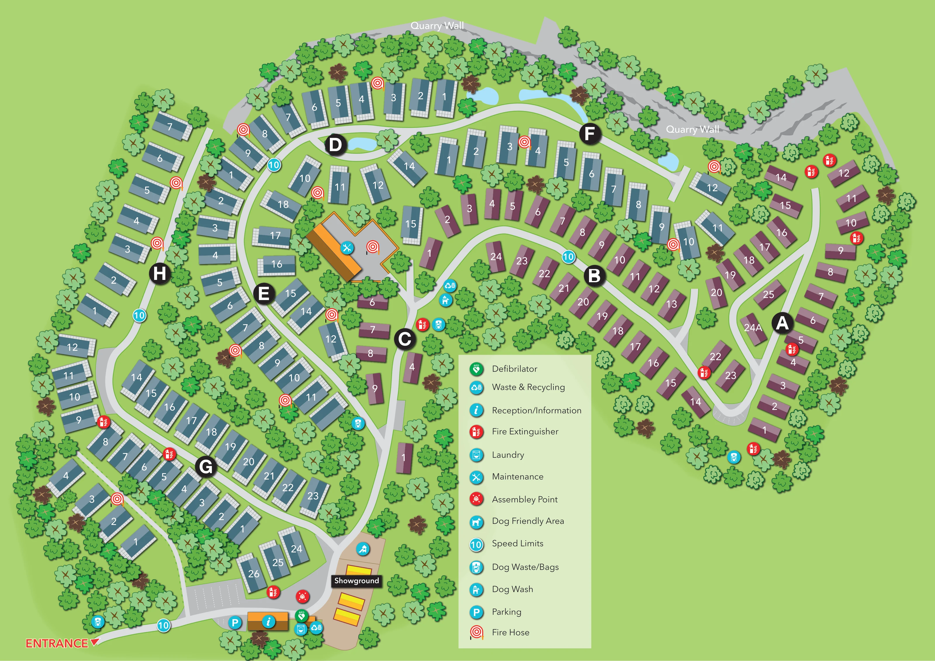
A broad irregular grey rock band, labelled Quarry Wall, follows the upper boundary and bends around the upper-right side.
ILLUSTRATED PARK MAP · P655
Harmby, Leyburn, North Yorkshire · United Kingdom
 Enlarge the map ↗
A SENSE OF THE PLACE
Yorkshire Dales Country and Leisure Park is a holiday home park at Harmby near Leyburn. Landscaped grounds, woodland and old quarry walls give the site its individual character.
The park provides a base for enjoying the surrounding Yorkshire Dales and the shops and cafes of Leyburn. The map presents the holiday home areas and routes within the grounds.
LOOK CLOSER
A broad irregular grey rock band, labelled Quarry Wall, follows the upper boundary and bends around the upper-right side.
Dense tree symbols enclose the perimeter, separate accommodation rows and fill several substantial internal green spaces.
Several unlabelled pale-blue pond-like shapes lie beside the upper road and within the loop near area D.
Information symbol on the orange-roofed building beside the entrance parking and showground.
Parking symbol and marked bays near reception, with another bay-marked area at the lower end of the eastern accommodation roads.
Laundry symbol in the entrance-side service cluster beside reception.
Crossed-tools symbol identifies the large angular orange-and-grey building in the central-western part of the park.
Named tan-coloured display area beside the entrance facilities, containing several yellow-and-orange rectangular display units.
Information symbol on the orange-roofed building beside the entrance parking and showground.
Parking symbol and marked bays near reception, with another bay-marked area at the lower end of the eastern accommodation roads.
Laundry symbol in the entrance-side service cluster beside reception.
Crossed-tools symbol identifies the large angular orange-and-grey building in the central-western part of the park.
Named tan-coloured display area beside the entrance facilities, containing several yellow-and-orange rectangular display units.
Waste and recycling symbols appear near reception and beside the central road around area C.
Green AED symbol marks a point beside the reception-side facilities.
Red assembly-point symbol appears on the entrance-side road near the showground.
Repeated red extinguisher icons and red-and-white hose-reel symbols are distributed around the accommodation roads and service building.
A dog-friendly-area symbol is positioned at the upper end of the showground.
Dog-wash symbol appears beside the central road near area C and the waste and recycling point.
Repeated dog-waste/bag symbols mark locations near the entrance, central accommodation roads and eastern edge.
A broad irregular grey rock band, labelled Quarry Wall, follows the upper boundary and bends around the upper-right side.
Dense tree symbols enclose the perimeter, separate accommodation rows and fill several substantial internal green spaces.
Several unlabelled pale-blue pond-like shapes lie beside the upper road and within the loop near area D.
A prominent red ENTRANCE label and triangular pointer identify arrival from the lower-left edge.
Pale-grey roads branch from the entrance into linked curves, loops and short spurs serving the accommodation areas.
Large black circular markers labelled A to H provide section-level references alongside white individual home numbers.
Turquoise circular markers displaying 10 are positioned at the entrance and along several internal roads; the legend identifies them as speed limits.
READING THE MAP
This illustrated map of Yorkshire Dales Country & Leisure Park presents a holiday-home site at Harmby, near Leyburn in North Yorkshire. Its most distinctive landscape feature is the quarry wall running around the upper edge of the grounds, drawn as a broad grey rock face behind a belt of trees. Curving roads, planted spaces and small blue water features give the plan a less regular character than a conventional grid of plots.
The accommodation is organised into lettered areas, with individual homes numbered directly on their roof symbols. Blue-grey and plum-coloured buildings create contrasting visual groups, while large black area markers help visitors move from a broad section reference to a particular home. At the lower edge, a clearly marked entrance leads to parking, reception and a separate showground.
The map also brings practical details into the same view: laundry, maintenance, recycling, dog facilities and emergency equipment all have recognisable symbols. It is a useful example of a landscaped holiday-home park map that combines individual address finding with a clear picture of the site's unusual setting.
The plan begins at a red ENTRANCE label on the lower-left edge. A pale-grey road leads towards marked parking bays and an orange-roofed reception building, where information, laundry, waste and recycling, and a green AED marker are grouped. Nearby, a red assembly-point symbol sits beside the road. The adjoining tan showground contains yellow-and-orange display units and a dog-friendly-area marker.
Beyond this arrival cluster, the road network branches through accommodation areas identified by large black discs labelled A to H. Blue-grey homes occupy much of the western side and the upper roadside, while plum-coloured homes form the eastern groups and part of the central spine. Each home carries a white number. Many blue-grey symbols also have gridded white margins suggesting terraces or hardstanding, adding detail without obscuring the address labels.
The western roads curve around planted interiors and connect to an upper loop near area D. On the eastern side, branching roads and a rounded lower end organise homes around wooded green spaces. A large angular maintenance building sits within the central-western accommodation, clearly distinguished by its orange edge and crossed-tools symbol.
Across the upper boundary, the labelled quarry wall is illustrated with jagged edges and darker rock markings. Trees line its base and continue around the park perimeter, with several pale-blue water shapes beside the upper road. Dog-waste points, a central dog wash, fire extinguishers and hose reels are mapped within the grounds. Turquoise 10 markers punctuate the roads. A tall, pale-green legend explains the facility symbols in the open lower-right portion of the single-page composition.
KEEP EXPLORING
Chosen for shared landscapes, accommodation or facilities.
 Explore the map ↗
United Kingdom
A wooded Allerton park plan with colour-coded neighbourhoods, touring pitches and a central facilities hub.
 Explore the map ↗
United Kingdom
Ashby Park map with seven fishing lakes, colour-coded accommodation and illustrated wooded shorelines.
 Explore the map ↗
United Kingdom
A tree-framed riverside park map with numbered caravans, linked road loops and a compact entrance facilities key.
Features may come from the sample artwork, its key or published park information. Approximate numbers describe the drawing and may cover only part of a park. They are intended to help you compare map examples. Current facilities and booking information should be checked with the park.
LET’S MAP YOUR PARK
For a map quotation, find your park and draw a rough boundary around it. The area you select helps us work out the design time and price.
Draw your park for a quote ↗Or talk to our map designers
01751 473136