
Edible garden
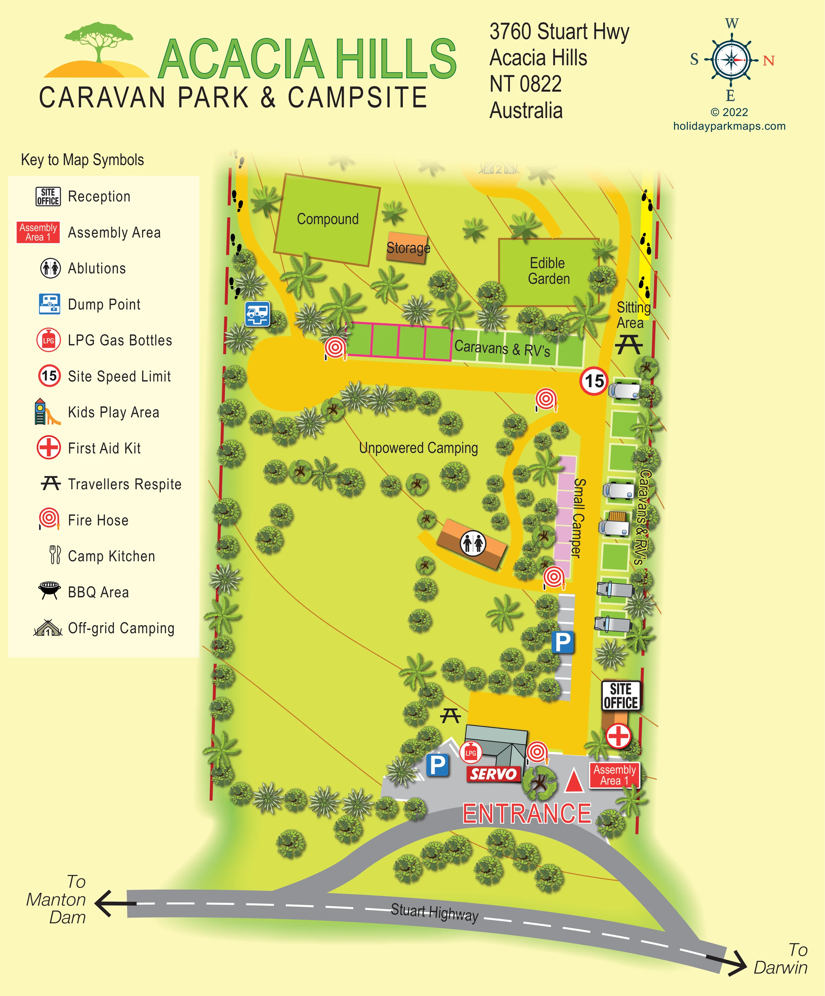
A large outlined green rectangle above the caravan/RV strip is labelled Edible Garden.
ILLUSTRATED PARK MAP · P391
3760 Stuart Highway, Acacia Hills, Northern Territory · Australia
 Enlarge the map ↗
A SENSE OF THE PLACE
Acacia Hills Caravan Park provides a rural stopping place on the Stuart Highway in Australia's Northern Territory. Its accommodation includes powered and unpowered sites, drive-through spaces and simple swag rooms.
The park caters for travellers with a range of camping and touring setups. Larger rigs and off-grid stays can be discussed with the park, making the site a practical base for a Northern Territory road trip.
LOOK CLOSER
A large outlined green rectangle above the caravan/RV strip is labelled Edible Garden.
Palms, broad-leaved trees and rounded shrubs frame the pitches and scatter across the open camping ground.
A prominent site-office symbol marks reception beside the right-hand entrance road.
A roofed building with an ablutions symbol stands beside the curved internal route, between open camping and the small-camper strip.
A blue dump-point symbol appears near the left end of the upper caravan/RV strip.
An LPG marker is placed beside the entrance-side building labelled SERVO.
A building at the arrival forecourt is labelled SERVO, using the Australian term for a service station.
Blue P symbols identify parking at the entrance forecourt and a marked strip beside the internal road.
A prominent site-office symbol marks reception beside the right-hand entrance road.
A roofed building with an ablutions symbol stands beside the curved internal route, between open camping and the small-camper strip.
A blue dump-point symbol appears near the left end of the upper caravan/RV strip.
An LPG marker is placed beside the entrance-side building labelled SERVO.
A building at the arrival forecourt is labelled SERVO, using the Australian term for a service station.
Blue P symbols identify parking at the entrance forecourt and a marked strip beside the internal road.
Picnic-table symbols appear near the entrance and beside the upper right-hand road; the latter is labelled Sitting Area.
A large outlined green rectangle above the caravan/RV strip is labelled Edible Garden.
A sizeable compound and a smaller storage building are labelled in the upper-left part of the plan.
Repeated red hose-reel symbols are distributed around the arrival area and accommodation roads.
A red-cross symbol marks first aid near reception.
A red assembly-area label stands beside the entrance forecourt.
A circular 15 marker appears at the junction of the upper pitch strip and the right-hand internal road.
A play-tower symbol is included in the key, but a corresponding location is not clearly identifiable on the plan.
Cutlery symbols identify this facility in the key; no clear placement is visible in the main plan.
A barbecue symbol is listed in the key, without a clearly visible mapped position.
A broad grey highway runs across the bottom, with curved access connections leading into the entrance forecourt.
Large arrows at opposite ends of the highway indicate Darwin to the right and Manton Dam to the left.
Golden-yellow routes serve the pitch strips and curve around the ablutions building. Black footprint marks follow portions of the side boundaries.
Palms, broad-leaved trees and rounded shrubs frame the pitches and scatter across the open camping ground.
READING THE MAP
This illustrated map presents Acacia Hills Caravan Park & Campsite as a leafy roadside stopping place on the Stuart Highway in Australia's Northern Territory. A broad grey highway anchors the page, with arrows towards Darwin and Manton Dam and curved access lanes leading into a clearly marked entrance. From there, golden-yellow internal roads connect reception, parking and the accommodation areas.
The design distinguishes orderly caravan and RV strips from the more open camping landscape. Green pitch rectangles follow the main roads, a pink strip identifies small-camper spaces, and the central unpowered camping area is scattered with palms and rounded tree canopies. An edible garden, compound and storage area give the upper part of the plan its own character.
A tall symbol key sits beside the artwork, while large service and safety icons make important arrival points easy to pick out. The oversized green park name, warm yellow background and tree-and-hills logo complete a portrait-format design that combines practical touring information with a recognisable tropical setting.
The plan is arranged around the approach from Stuart Highway, shown across the bottom with a dashed white centre line. Grey access lanes curve into a forecourt where the SERVO building, LPG marker and parking symbol establish the arrival hub. Reception sits beside the right-hand road, close to first aid and Assembly Area 1. Large entrance lettering ties these elements together visually.
Beyond the forecourt, a golden-yellow road follows the right edge of the site. Green caravan and RV spaces line its outer side, with several illustrated vehicles showing how the strip is used. A shorter pink row labelled Small Camper sits on the inner side. Farther up, a second green caravan/RV strip extends across the plan beside a broad turning area. A dump point marks its left end, while a sitting area is shown near its right end.
The central and left-hand ground is less formal. The Unpowered Camping label sits among scattered trees, and a curved route leads to an orange-roofed ablutions building. Above the pitch strip, separate labels identify the compound, storage and edible garden. An off-grid camping symbol appears near the softly faded upper edge. Picnic-table and fire-hose symbols recur around the site, and black footprint marks follow parts of the boundaries.
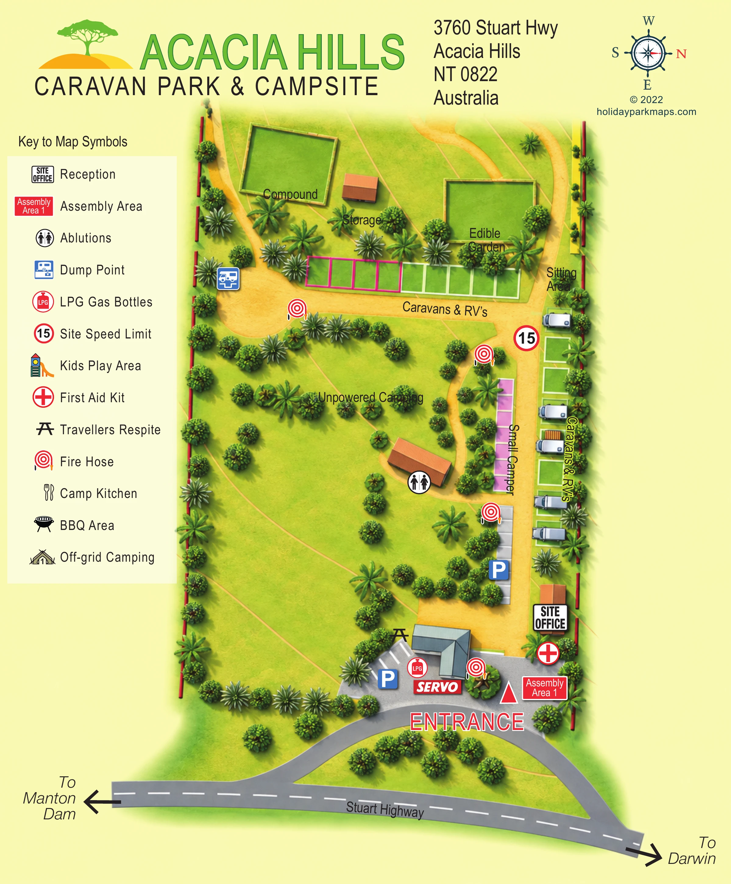
The left-hand key explains the service and safety pictograms and also lists a kids play area, camp kitchen and BBQ area, whose positions are not clearly shown in the plan. A decorative compass places north to the right. The accompanying enlarged view makes the legend and nearby planting easier to read; it is a detail of the same artwork, not a separate map.
 Enlarge this map ↗
KEEP EXPLORING
Chosen for shared landscapes, accommodation or facilities.
 Explore the map ↗
United Kingdom
Illustrated touring and camping map with hedge-divided fields, age-labelled play areas and a detailed service key.
 Explore the map ↗
United Kingdom
Woodland park map with mixed pitches, bell tents, lodges and a fishing lake.
 Explore the map ↗
United Kingdom
Tree-framed mixed-accommodation park map with two entrances, touring loops and a clearly illustrated social hub.
Features may come from the sample artwork, its key or published park information. Approximate numbers describe the drawing and may cover only part of a park. They are intended to help you compare map examples. Current facilities and booking information should be checked with the park.
TAKE A CLOSER LOOK
View the illustrated map in detail or choose a file to download. These are sample maps; contact the park for current visitor information.

LET’S MAP YOUR PARK
For a map quotation, find your park and draw a rough boundary around it. The area you select helps us work out the design time and price.
Draw your park for a quote ↗Or talk to our map designers
01751 473136
