
Lakes and ponds
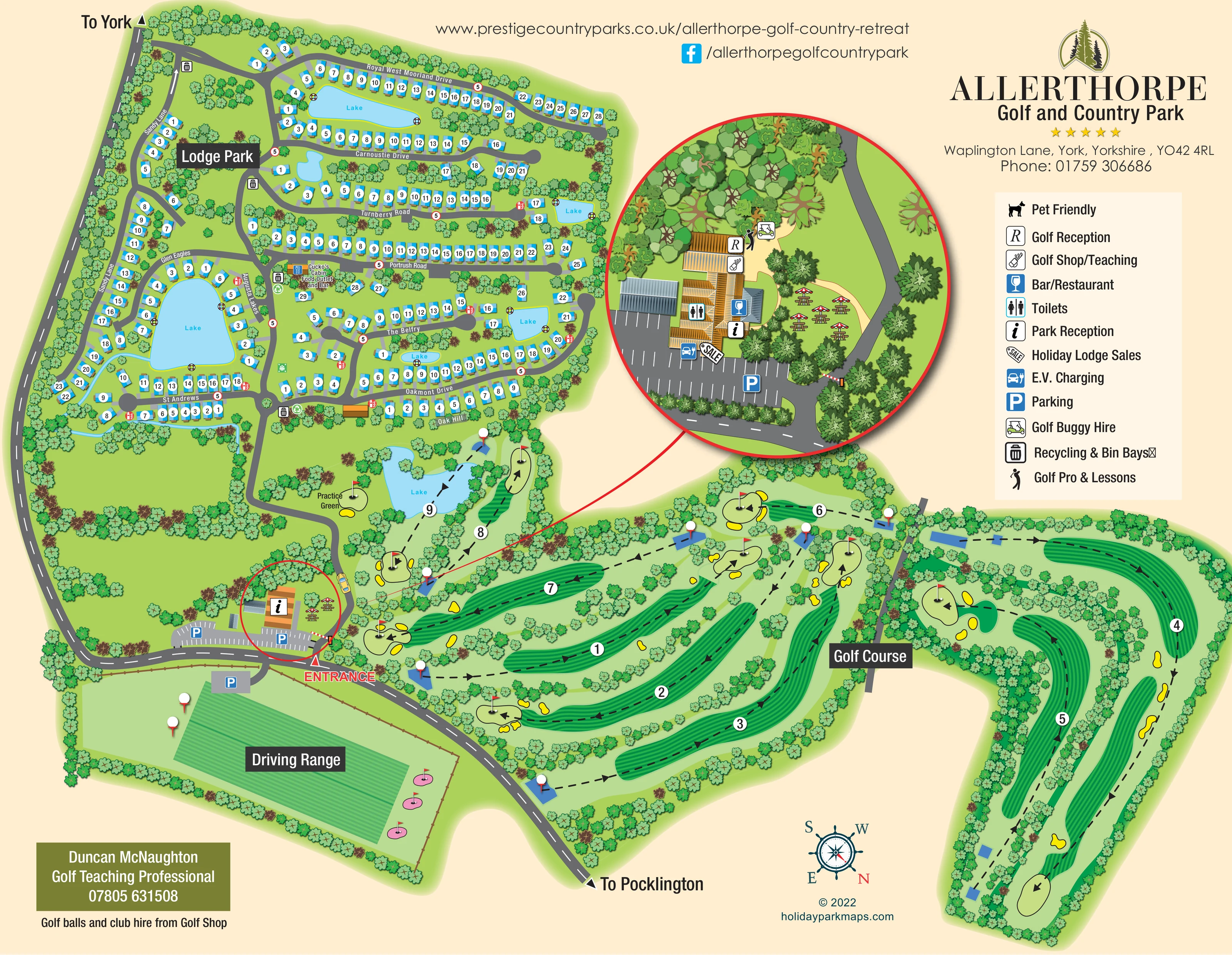
Blue water features punctuate the lodge neighbourhoods, including a prominent lake enclosed by accommodation roads. Another lake lies among the golf holes near the practice green.
ILLUSTRATED PARK MAP · P005
Waplington Lane, York, Yorkshire · United Kingdom
 Enlarge the map ↗
A SENSE OF THE PLACE
Allerthorpe Golf and Country Park is a lodge retreat near York, with landscaped grounds, lakes and golf shaping its setting. It offers both lodge holidays and holiday home ownership.
Dining and golf give guests options within the park, while York provides a contrast to the surrounding countryside. The map helps show how the lodge areas and leisure spaces fit together across the site.
LOOK CLOSER
Blue water features punctuate the lodge neighbourhoods, including a prominent lake enclosed by accommodation roads. Another lake lies among the golf holes near the practice green.
Dense illustrated tree belts define the site edges, divide golf fairways and soften the spaces between lodge groups.
Nine numbered holes occupy the lower and right-hand portions of the artwork, with striped fairways, tee areas, flagged greens, bunkers and dashed directional lines.
A separate labelled range lies below the approach road, illustrated with striped turf, targets and nearby parking.
A labelled practice green sits between the lodge area and the entrance-side golf holes.
The information symbol marks the entrance building on the main plan and in the enlarged circular inset.
Located on the entrance complex in the circular enlargement using the legend's R symbol.
The enlarged entrance complex carries the golf shop/teaching symbol.
Nine numbered holes occupy the lower and right-hand portions of the artwork, with striped fairways, tee areas, flagged greens, bunkers and dashed directional lines.
A separate labelled range lies below the approach road, illustrated with striped turf, targets and nearby parking.
A labelled practice green sits between the lodge area and the entrance-side golf holes.
The information symbol marks the entrance building on the main plan and in the enlarged circular inset.
Located on the entrance complex in the circular enlargement using the legend's R symbol.
The enlarged entrance complex carries the golf shop/teaching symbol.
A lower-page panel names a golf teaching professional and states that golf balls and club hire are available from the golf shop; a golf professional symbol also appears in the inset.
A buggy-hire symbol is positioned beside the golf reception area in the entrance enlargement.
The entrance complex is marked with the bar/restaurant symbol and illustrated with an adjoining outdoor seating area.
A separately labelled food outlet and bar stands within the lodge area beside the central access road, near Portrush Road.
Parasol-covered picnic tables are illustrated beside the entrance building, most clearly in the circular inset.
A toilet symbol is positioned on the entrance complex in the enlarged inset.
A sales symbol identifies the entrance complex as a point for holiday lodge sales.
An EV charging symbol is placed beside the entrance building and parking in the inset.
Blue parking symbols identify bays beside the reception complex and a separate parking area serving the driving range.
Bin and recycling symbols recur at several points along the lodge roads, including near the central food outlet.
Repeated red fire-equipment symbols appear beside lodge roads. They are visually identifiable but are not explained in the displayed legend.
A green assembly-point-style symbol appears beside the central lodge access road; the displayed legend does not explain it.
A dog symbol and 'Pet Friendly' entry appear in the legend as a general park attribute, without identifying a particular mapped facility or area.
Blue water features punctuate the lodge neighbourhoods, including a prominent lake enclosed by accommodation roads. Another lake lies among the golf holes near the practice green.
Dense illustrated tree belts define the site edges, divide golf fairways and soften the spaces between lodge groups.
A red entrance label and pointer identify the turn from the approach road into the reception area; a barrier is drawn across the internal access.
The road along the left and lower edges has outward arrows labelled 'To York' and 'To Pocklington'.
Road names provide local orientation, including Sandy Lane, Royal West Moorland Drive, Carnoustie Drive, Turnberry Road, Portrush Road, Glen Eagles, Augusta Lakes, St Andrews, The Belfry, Oakmont Drive and Oak Hill.
READING THE MAP
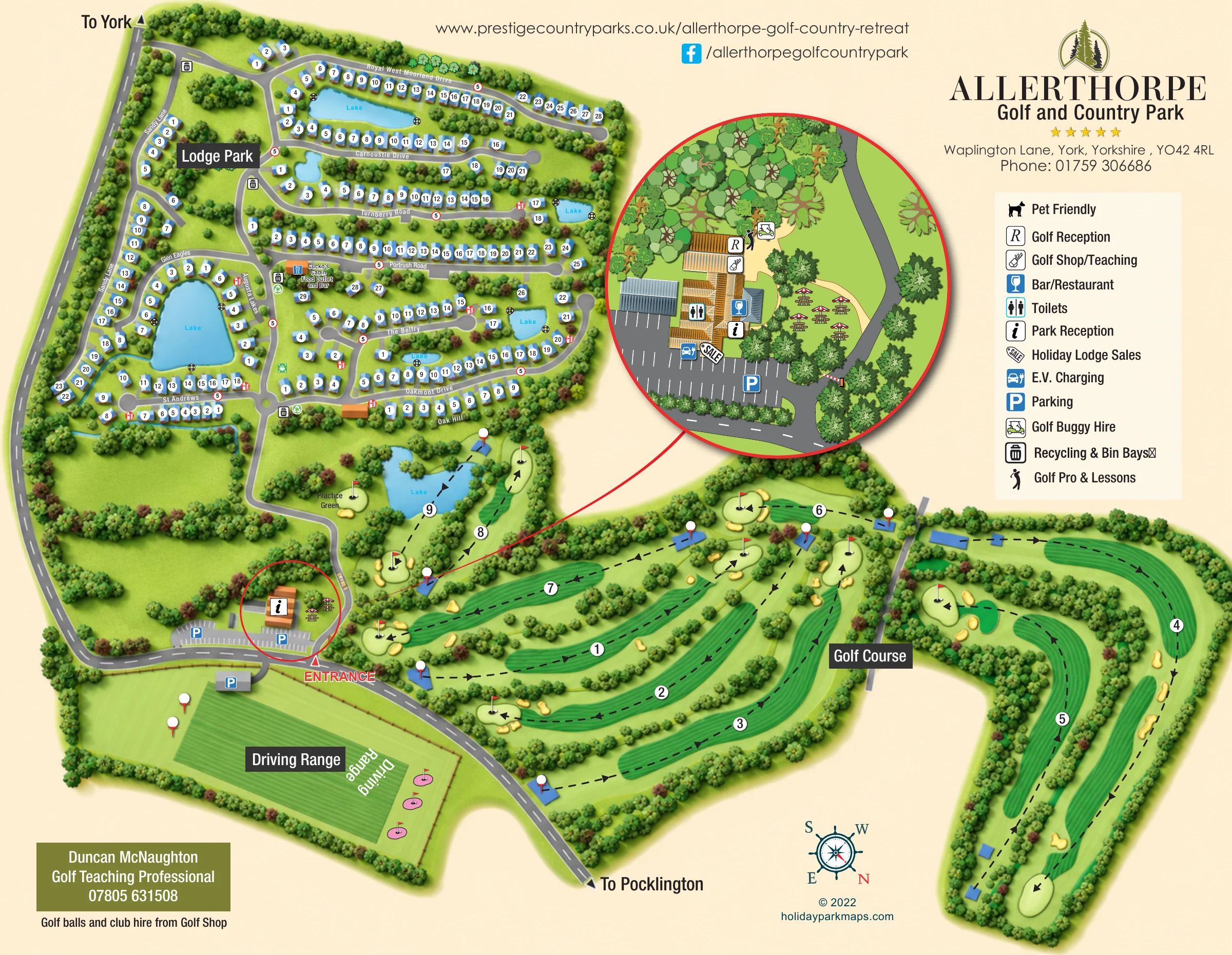
This illustrated map of Allerthorpe Golf & Country Park brings together a lodge retreat, lakes and a nine-hole golf course near York in Yorkshire. The accommodation occupies the upper-left part of the plan, where blue lodge symbols follow named drives and curve around water features. Below and to the right, striped fairways, flagged greens and yellow bunkers give the golf course a distinctly different visual character.
The map balances this broad landscape overview with practical arrival information. A prominent entrance label leads visitors towards reception and parking, while a large circular enlargement explains the facilities clustered around the entrance building. Golf reception, the shop and teaching area, bar/restaurant, toilets, lodge sales and EV charging are all identified there. A separate driving range and practice green complete the golfing picture.
For a designer’s gallery, this is a useful example of a country-park map that must explain both accommodation neighbourhoods and a substantial leisure landscape without treating either as an afterthought.
The main plan is organised around three clearly labelled areas: Lodge Park, Golf Course and Driving Range. A grey approach road runs down the left edge and across the lower portion of the artwork, with arrows towards York and Pocklington. The red entrance marker picks out the turn into the park, where reception buildings, parking and a barrier establish the arrival point.
Within the lodge area, a central road connects a series of named drives. Royal West Moorland Drive, Carnoustie Drive, Turnberry Road and Portrush Road form long accommodation rows, while St Andrews, Augusta Lakes and Glen Eagles help define the neighbourhood around the largest lodge-area lake. Other groups follow The Belfry, Oakmont Drive and Oak Hill. Blue roofs, white number badges and short pale driveways provide a consistent visual language across approximately 200 illustrated lodge plots. Trees and smaller lakes break up the rows, and Cucko’s Cabin Food Outlet and Bar is labelled near the central route. Bin, recycling and fire-point symbols appear at intervals.
The golf course spreads across the bottom and right of the page. Numbered holes, dashed directional arrows, blue tee areas, striped fairways, pale greens and bright bunkers distinguish its structure from the accommodation roads. A practice green is labelled near the lake beside the lodge boundary, while the driving range occupies a separate rectangular area below the approach road.
A red-bordered circular inset enlarges the entrance complex, showing reception functions, golf services, dining, toilets, charging, parking and outdoor tables. This inset belongs to the same plan, providing additional detail rather than depicting another section of accommodation.
 Enlarge this map ↗
KEEP EXPLORING
Chosen for shared landscapes, accommodation or facilities.
 Explore the map ↗
United Kingdom
Woodland camping, lodges, lakes and colour-coded bike trails at Avon Tyrrell Outdoor Centre.
 Explore the map ↗
United Kingdom
Illustrated lakeside park plan with numbered holiday units, leisure buildings and a looping Woodland Walk.
 Explore the map ↗
United Kingdom
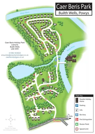
Portrait holiday-home park map with riverside loops, a tree-fringed pond and a separate manor landmark.
Features may come from the sample artwork, its key or published park information. Approximate numbers describe the drawing and may cover only part of a park. They are intended to help you compare map examples. Current facilities and booking information should be checked with the park.
TAKE A CLOSER LOOK
View the illustrated map in detail or choose a file to download. These are sample maps; contact the park for current visitor information.


LET’S MAP YOUR PARK
For a map quotation, find your park and draw a rough boundary around it. The area you select helps us work out the design time and price.
Draw your park for a quote ↗Or talk to our map designers
01751 473136
 allerthorpeamended.png
 allerthorpeamended_large.png