
River Irfon
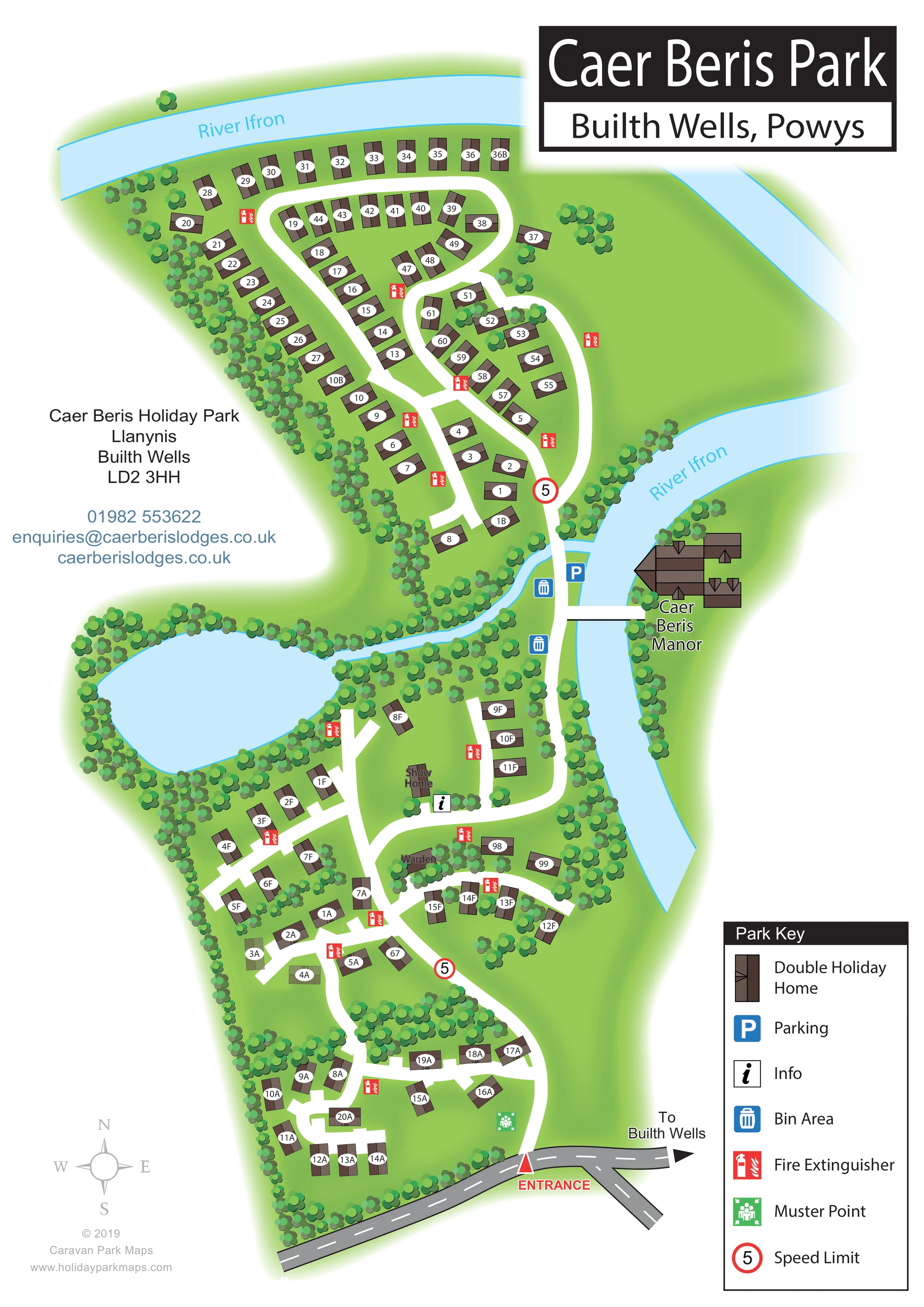
A broad pale-blue river curves across the top and down the eastern side of the park. The artwork labels it 'River Ifron'.
ILLUSTRATED PARK MAP · P429
Caer Beris Holiday Park, Llanynis, Builth Wells · United Kingdom
 Enlarge the map ↗
A SENSE OF THE PLACE
Caer Beris Holiday Lodge Park is located beside the River Irfon near Builth Wells in Powys. Landscaped grounds provide the setting for private holiday lodges.
The park promotes lodge ownership, with a choice of homes and development areas. Its riverside position and access to the countryside around Builth Wells are central to its character, and the map helps explain the arrangement of lodges and internal routes.
LOOK CLOSER
A broad pale-blue river curves across the top and down the eastern side of the park. The artwork labels it 'River Ifron'.
An unlabelled, rounded waterbody lies west of the central accommodation area, enclosed by dense tree symbols.
A slim blue channel runs from the pond towards the riverside corridor and is crossed by the main internal route.
Closely grouped tree canopies trace the western boundary, pond edge and riverbanks, with smaller groups between homes and roads.
A large, individually drawn brown-roofed building is labelled across the river, with a white access connection from the park's central route. Its services are not specified.
A red triangular marker and bold ENTRANCE label identify access from the grey public road at the southern end.
White roads connect southern residential loops to the central facilities and northern riverside accommodation, with short branches serving smaller groups.
A labelled arrow points along the public road to the right of the entrance.
A broad pale-blue river curves across the top and down the eastern side of the park. The artwork labels it 'River Ifron'.
An unlabelled, rounded waterbody lies west of the central accommodation area, enclosed by dense tree symbols.
A slim blue channel runs from the pond towards the riverside corridor and is crossed by the main internal route.
Closely grouped tree canopies trace the western boundary, pond edge and riverbanks, with smaller groups between homes and roads.
A red triangular marker and bold ENTRANCE label identify access from the grey public road at the southern end.
White roads connect southern residential loops to the central facilities and northern riverside accommodation, with short branches serving smaller groups.
A labelled arrow points along the public road to the right of the entrance.
A blue P symbol marks parking beside the main route near the river and the approach to Caer Beris Manor.
A black information symbol is positioned beside the show home in the central part of the plan.
A separately labelled building stands near the central road junction and information symbol.
A small brown building labelled Warden sits among trees just south of the show-home area.
Blue bin symbols are grouped along the central riverside access corridor.
Repeated red fire-extinguisher symbols are distributed through both accommodation areas.
A green assembly symbol marks a location inside the southern loop near the entrance.
Red-ringed signs displaying 5 appear on the main internal route; the key identifies them as speed-limit symbols.
A large, individually drawn brown-roofed building is labelled across the river, with a white access connection from the park's central route. Its services are not specified.
READING THE MAP
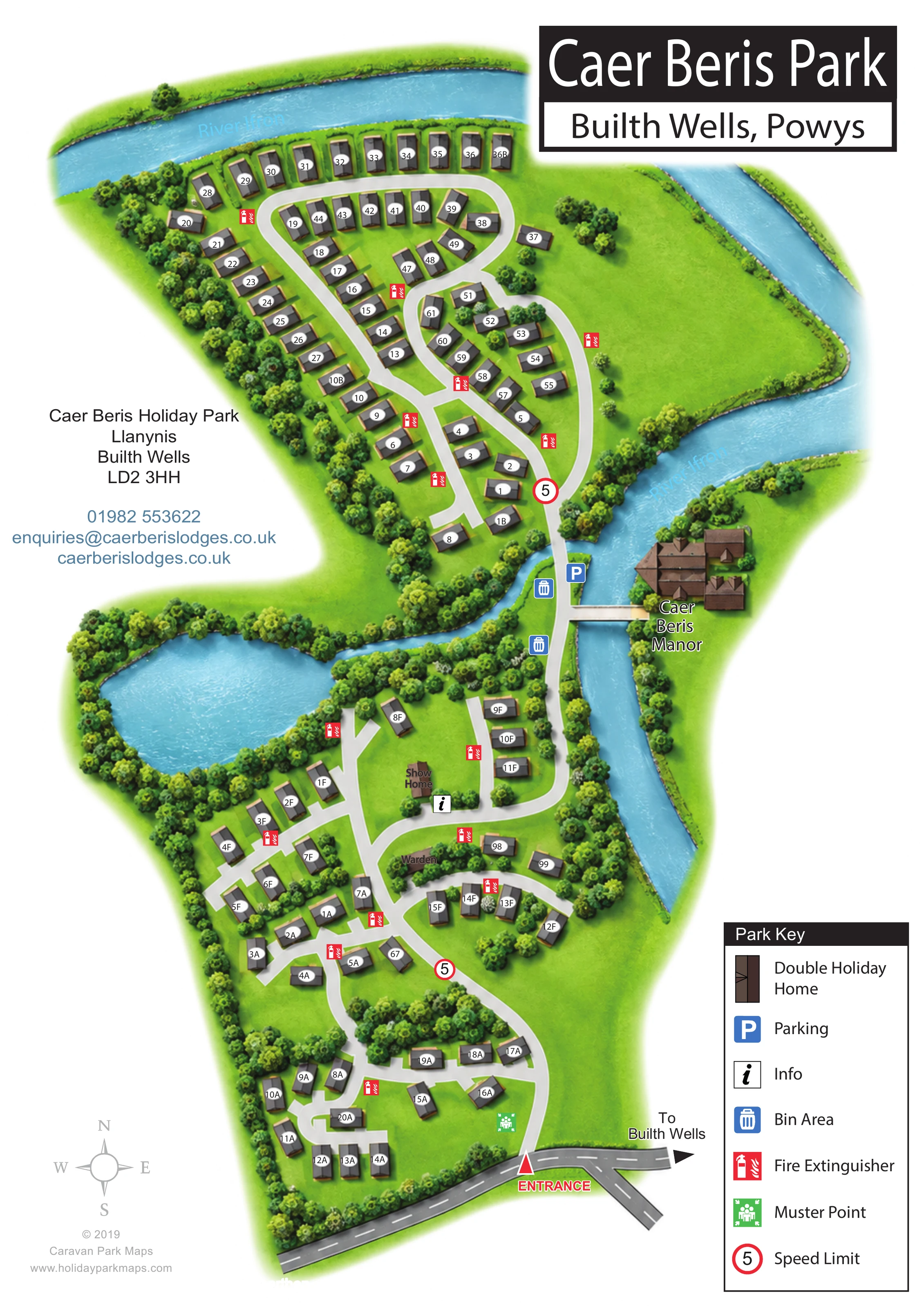
This illustrated map of Caer Beris Holiday Park places its holiday homes within a distinctive riverside landscape near Builth Wells in Powys. The River Irfon curves around the upper and right-hand edges of the plan, while a large tree-fringed pond gives the central grounds another clear visual landmark. Brown roof symbols, white internal roads and clusters of green tree canopies make the arrangement of accommodation easy to follow without losing the character of the setting.
The portrait layout follows the park from its southern entrance through smaller residential loops to a broader northern group of homes. Along the way, the map identifies the show home, information point, warden building, parking and bin areas. Fire-extinguisher points, a muster point and speed-limit symbols are integrated into the same visual system. Caer Beris Manor appears across the river as a separately illustrated landmark.
A large title panel, compact contact block and boxed Park Key complete the page. This sample is particularly relevant to lodge and holiday-home parks that need to explain a long, landscaped site with several accommodation clusters and a strong relationship to water.
The plan begins at a clearly marked entrance on the grey public road at the bottom of the page. A direction arrow points towards Builth Wells, while the internal road changes to a broad white ribbon that curves north through the grounds. The southern accommodation is arranged in small groups around loops and short branches, with trees separating homes and defining the outer boundary. A green muster-point symbol sits within the entrance-side loop.
Further north, the road reaches the warden building and the show home. An information symbol beside the show home makes this central area a useful orientation point. To the west, a large unlabelled pond is almost completely framed by trees. A narrow blue channel extends towards the river and passes beneath the main route. Parking and bin symbols sit along this central corridor, and a side connection leads across the river towards the individually drawn Caer Beris Manor.
The northern section opens into a larger arrangement of holiday homes beside the river. Rows and crescents follow nested road loops, with trees concentrated along the western edge and in smaller groups between buildings. Each home uses a simplified roof symbol and a white oval plot label. Red fire-extinguisher symbols recur throughout the plan, and red-ringed speed-limit signs punctuate the principal route.
The full composition is supported by a lower-right legend, an upper-right title panel, a left-hand contact block and a compass at lower left. The single portrait artwork combines accommodation wayfinding with landscape illustration; the enlarged details show portions of this same page rather than separate park sections.
 Enlarge this map ↗
KEEP EXPLORING
Chosen for shared landscapes, accommodation or facilities.
 Explore the map ↗
United Kingdom
Illustrated lakeside park plan with numbered holiday units, leisure buildings and a looping Woodland Walk.
 Explore the map ↗
United Kingdom
Numbered holiday-home plots, a wooded lake and the River Dane in a branded portrait park map.
 Explore the map ↗
United Kingdom
Woodland camping, lodges, lakes and colour-coded bike trails at Avon Tyrrell Outdoor Centre.
Features may come from the sample artwork, its key or published park information. Approximate numbers describe the drawing and may cover only part of a park. They are intended to help you compare map examples. Current facilities and booking information should be checked with the park.
TAKE A CLOSER LOOK
View the illustrated map in detail or choose a file to download. These are sample maps; contact the park for current visitor information.


LET’S MAP YOUR PARK
For a map quotation, find your park and draw a rough boundary around it. The area you select helps us work out the design time and price.
Draw your park for a quote ↗Or talk to our map designers
01751 473136