
Benar Beach and sea
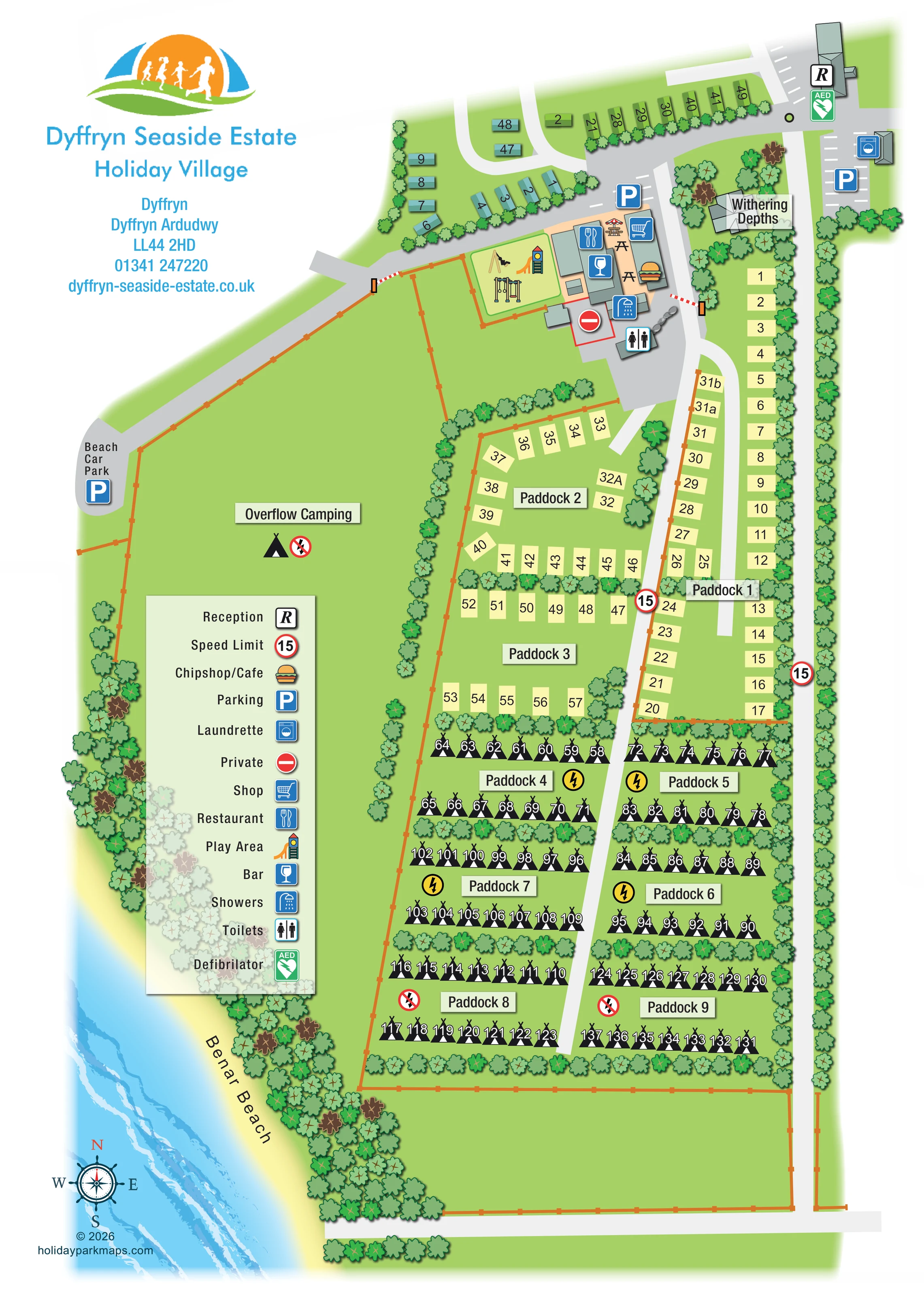
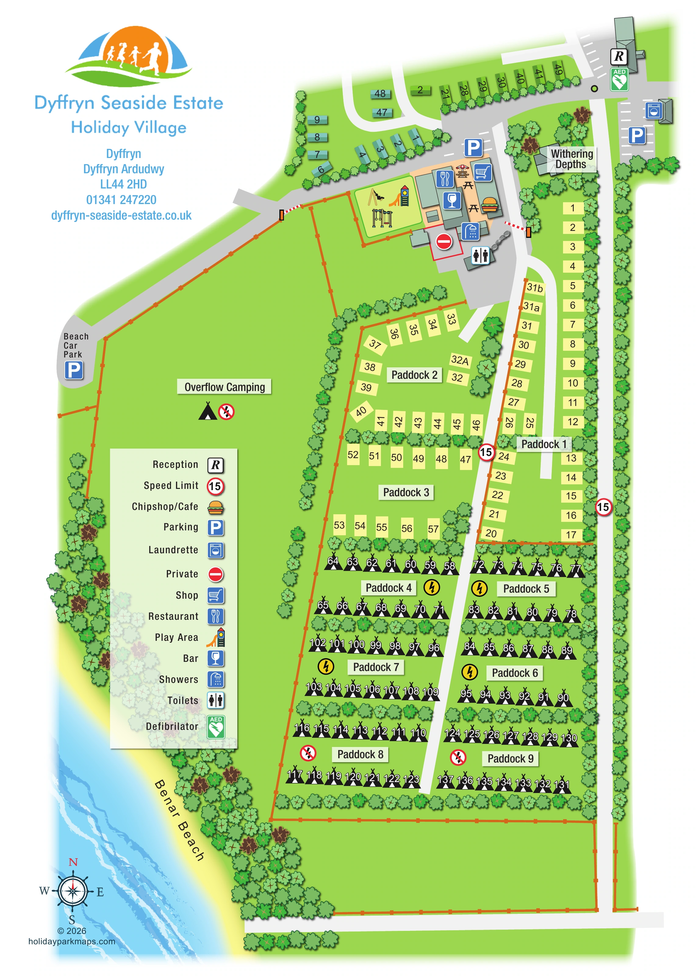
Benar Beach is labelled along the lower-left shoreline, illustrated with pale-yellow sand, blue water and bands of surf.
ILLUSTRATED PARK MAP · P105
Dyffryn, Dyffryn Ardudwy · United Kingdom
 Enlarge the map ↗
A SENSE OF THE PLACE
Dyffryn Seaside Estate is based at Dyffryn, Dyffryn Ardudwy. Dunes near the estate include a site of special scientific interest. The 2026 booking form lists holiday bungalows, lodges and caravans.
Facilities include a pub, restaurant, fish-and-chip shop, laundrette and general store. The park provides a leisure complex and children's play park.
LOOK CLOSER
Benar Beach is labelled along the lower-left shoreline, illustrated with pale-yellow sand, blue water and bands of surf.
Repeated leafy tree symbols line the coast, outer boundaries, roads and divisions between pitch rows.
The large overflow camping field occupies the western side; an additional unlabelled fenced grass area lies below the numbered paddocks.
An R marker identifies reception in the upper-right arrival area.
A green AED marker is positioned beside reception.
Blue parking markers and white bay markings identify parking near reception, the laundrette and the central amenities.
A labelled beach car park sits at the end of the diagonal road along the overflow field.
A washing-machine marker identifies a separate building beside the upper-right parking area.
An R marker identifies reception in the upper-right arrival area.
A green AED marker is positioned beside reception.
Blue parking markers and white bay markings identify parking near reception, the laundrette and the central amenities.
A labelled beach car park sits at the end of the diagonal road along the overflow field.
A washing-machine marker identifies a separate building beside the upper-right parking area.
A shopping-trolley marker locates the shop in the central amenities cluster.
A cutlery marker identifies the restaurant beside the play area.
A drinking-glass marker identifies the bar within the amenities group.
A burger illustration, explained by the legend, marks the chip shop/café beside the shop.
Several picnic tables, including one with a parasol, occupy the peach-coloured space between the amenity buildings.
An enclosed play area next to the amenities is illustrated with a slide tower, swings and climbing equipment.
Separate shower and toilet markers identify facilities on the southern side of the amenities cluster.
Yellow lightning symbols distinguish Paddocks 4–7 from the crossed-out lightning symbols in Paddocks 8–9 and Overflow Camping. These symbols are not separately explained in the main legend.
Benar Beach is labelled along the lower-left shoreline, illustrated with pale-yellow sand, blue water and bands of surf.
Repeated leafy tree symbols line the coast, outer boundaries, roads and divisions between pitch rows.
The large overflow camping field occupies the western side; an additional unlabelled fenced grass area lies below the numbered paddocks.
Grey roads connect arrival, amenities, the beach car park and the paddocks. Red-and-white barriers appear beside the amenities and on the beach-car-park branch.
Red-ringed 15 markers appear on internal routes and are explained as speed-limit symbols in the legend.
A red-outlined area beside the amenities carries the legend's Private symbol.
A tree-surrounded building near the arrival area is labelled Withering Depths; its function is not specified.
The park information describes a leisure complex, but the artwork does not explicitly locate or label it.
The park information notes that nearby dunes include a site of special scientific interest. No protected-area boundary is shown on the map.
READING THE MAP
This illustrated map of Dyffryn Seaside Estate Holiday Village brings a coastal accommodation layout and its visitor facilities together on a single portrait page. Benar Beach runs along the lower-left edge, where pale sand, blue water and drawn surf give the plan an unmistakable seaside setting. Inland, green fields and bands of trees frame nine named paddocks, a separate group of roofed holiday units and a generous overflow camping area.
The map makes the park's different spaces easy to recognise without relying on pitch numbers alone. Pale rectangles distinguish the upper paddocks, black tent symbols identify the lower camping rows, and coloured roofs mark the accommodation near the arrival area. Reception and parking sit at the top right, while the restaurant, bar, shop, chip shop/café, washrooms and children's play area form a compact central hub.
For visitors, the useful story is how these areas connect: the main approach leads towards the facilities, internal roads serve the paddocks, and a diagonal branch reaches the beach car park. A large symbol key and nautical compass complete the coastal wayfinding design.
The single-page artwork is arranged around a long green site extending from the arrival area at the top towards the beach-side fields below. Reception is marked with an R beside an AED symbol in the upper-right corner. Nearby parking bays and a separate laundrette building establish the arrival facilities, while short road branches serve green and turquoise roofed holiday units across the upper part of the plan.
Below these units, the amenities cluster combines restaurant, bar, shop and chip shop/café markers with illustrated outdoor tables. An enclosed playground contains a slide tower, swings and climbing equipment. Showers and toilets sit on the lower side of the cluster, alongside a marked private area. The nearby tree-surrounded building carries the name Withering Depths. Red-and-white barriers mark two road connections around this part of the site.
The accommodation fields are divided into Paddocks 1–9. The first three use pale-yellow pitch rectangles, including a long strip alongside the eastern access branch. Further down, tent-marked pitches form paired paddocks on either side of a central road. Tree belts separate their rows, and lightning or crossed-out lightning symbols distinguish the electrical provision depicted for different camping areas. A large Overflow Camping field occupies the western side, with the beach-car-park road following its diagonal boundary.
Orange-brown fences, leafy tree symbols and grey roads provide a clear structural framework. Benar Beach curves along the lower-left margin, illustrated with yellow sand and blue surf. The title and contact block occupy the white upper-left corner; a translucent vertical legend and nautical compass balance the lower composition. The detail views enlarge this same plan rather than showing additional park sections.
KEEP EXPLORING
Chosen for shared landscapes, accommodation or facilities.
 Explore the map ↗
United Kingdom
A colour-zoned coastal park map with touring areas, woodland trails, ponds and a leisure club.
 Explore the map ↗
United Kingdom
Colour-coded accommodation, central leisure facilities and coastal paths on an illustrated headland park map.
 Explore the map ↗
United Kingdom
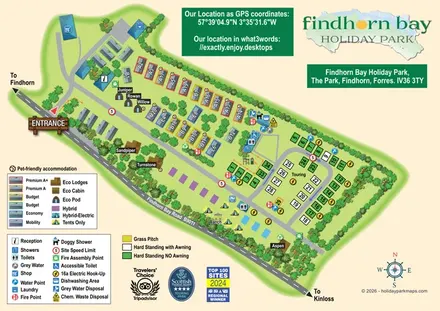
Illustrated mixed-accommodation park plan with colour-coded caravans, named eco units and a touring loop.
Features may come from the sample artwork, its key or published park information. Approximate numbers describe the drawing and may cover only part of a park. They are intended to help you compare map examples. Current facilities and booking information should be checked with the park.
TAKE A CLOSER LOOK
View the illustrated map in detail or choose a file to download. These are sample maps; contact the park for current visitor information.

LET’S MAP YOUR PARK
For a map quotation, find your park and draw a rough boundary around it. The area you select helps us work out the design time and price.
Draw your park for a quote ↗Or talk to our map designers
01751 473136