
Large open grass area
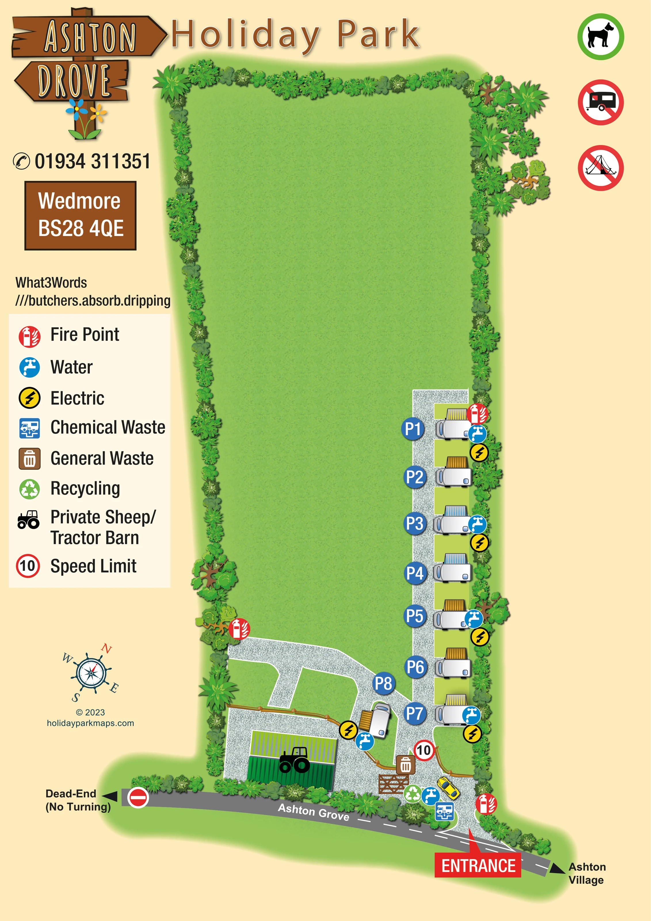
An extensive, unlabelled grass area occupies most of the upper and central site. It is not marked as a camping field.
ILLUSTRATED PARK MAP · P012
Wedmore, Somerset · United Kingdom
 Enlarge the map ↗
A SENSE OF THE PLACE
Ashton Drove Motorhome Park is based at Wedmore, Somerset. Secondary listings identify a motorhome touring site near Wedmore.
The map brings the site layout and its access routes together in one view, providing a reference for understanding the arrangement of the grounds.
LOOK CLOSER
An extensive, unlabelled grass area occupies most of the upper and central site. It is not marked as a camping field.
Dense illustrated trees, shrubs and leafy planting frame the site, with larger specimen trees breaking up the boundary.
Blue tap symbols recur beside the motorhome pitches and in the entrance service area.
Yellow lightning symbols mark several positions along the pitch row and beside the angled lower pitch.
A blue chemical-waste symbol identifies a disposal point close to the entrance.
Brown general-waste and green recycling symbols appear in the lower entrance and gate area.
Red fire-point symbols are positioned at the upper end of the pitch row, beside the lower cross-track and near the entrance.
A green corrugated barn with a tractor symbol stands beside the lower yard; the legend identifies it as a private sheep/tractor barn.
Blue tap symbols recur beside the motorhome pitches and in the entrance service area.
Yellow lightning symbols mark several positions along the pitch row and beside the angled lower pitch.
A blue chemical-waste symbol identifies a disposal point close to the entrance.
Brown general-waste and green recycling symbols appear in the lower entrance and gate area.
Red fire-point symbols are positioned at the upper end of the pitch row, beside the lower cross-track and near the entrance.
A green corrugated barn with a tractor symbol stands beside the lower yard; the legend identifies it as a private sheep/tractor barn.
An extensive, unlabelled grass area occupies most of the upper and central site. It is not marked as a camping field.
Dense illustrated trees, shrubs and leafy planting frame the site, with larger specimen trees breaking up the boundary.
A large red entrance pointer marks the connection between Ashton Grove and the gravel access track at the lower right.
The adjoining road is labelled Ashton Grove, with Ashton Village indicated to the right and Dead-End (No Turning) to the left.
A pale gravel spine serves the motorhome row and branches left around grass islands towards the barn yard. Timber fencing and a gate distinguish the lower private area.
A red-ringed 10 symbol appears on the internal approach and is explained as Speed Limit in the legend.
The left information column includes Wedmore, a postcode, telephone contact and a What3Words location reference.
The upper-right margin contains a green-ringed dog graphic and red prohibition-style caravan and tent graphics. These are artwork messages rather than mapped facility locations or confirmation of current policies.
READING THE MAP
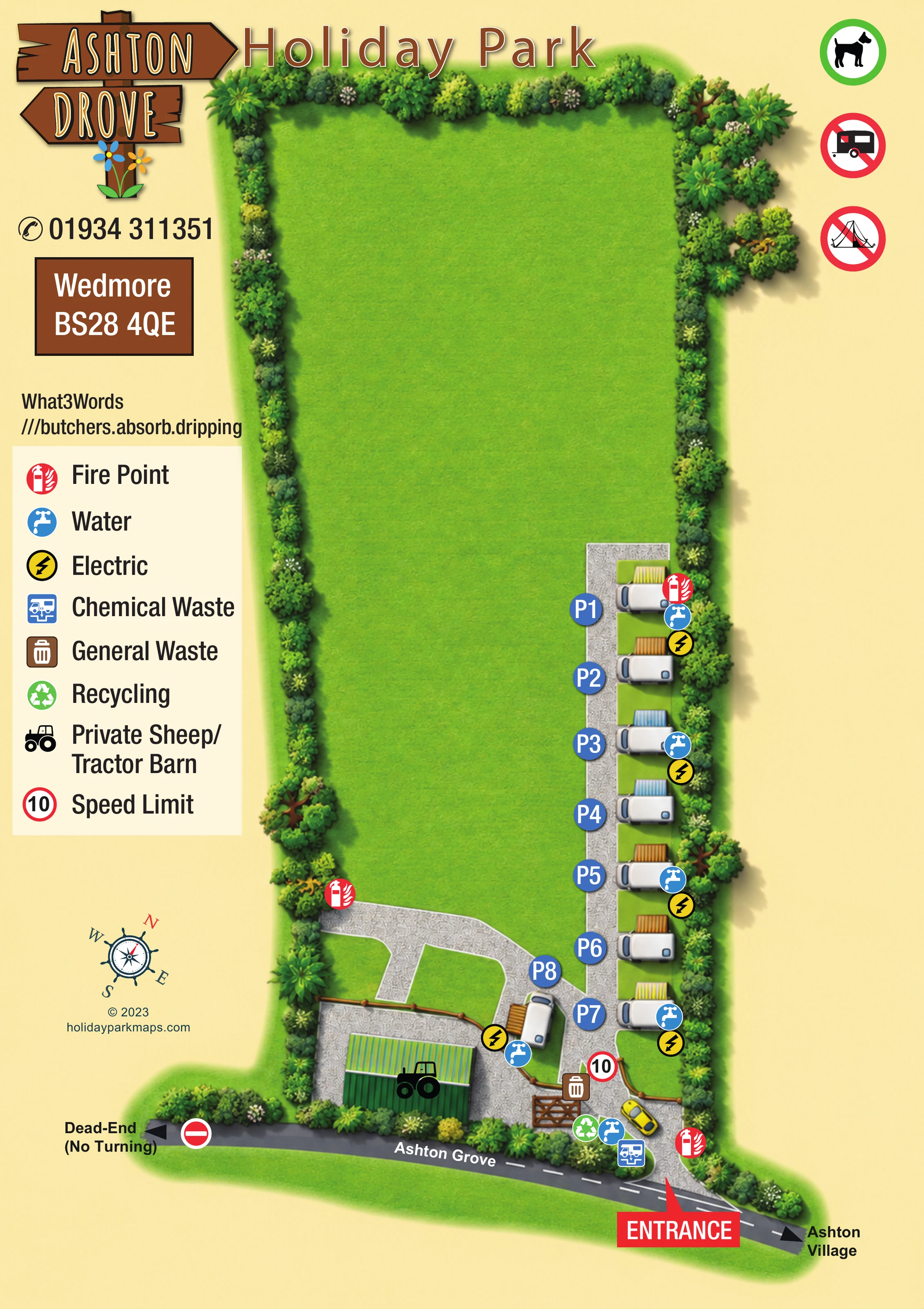
This illustrated map of Ashton Drove Motorhome Park in Wedmore, Somerset, brings a small motorhome site and its arrival route into one portrait-format view. The artwork is headed Ashton Drove Holiday Park, using a rustic timber sign and a warm cream background to introduce a distinctly green, enclosed setting.
Most of the plan is occupied by an open grass area framed with trees and shrubs. The motorhome pitches form a short, orderly row along the right-hand edge, reached by a pale gravel track from the entrance below. Individual vehicle illustrations, striped awnings and large blue pitch markers give this compact accommodation area a clear visual identity.
Practical information is given considerable space. Water, electric hook-ups, fire points and waste facilities are shown with bright symbols, while the adjoining road carries both a village-direction arrow and a dead-end annotation. A private sheep/tractor barn is also distinguished from the visitor pitches. The result is a sample focused on arrival, pitch finding and essential services rather than a large resort’s leisure attractions.
The portrait plan places the entrance at the lower right, where a red pointer connects the site to the grey road labelled Ashton Grove. Ashton Village is indicated at the right-hand end of the road; the opposite end carries the wording Dead-End (No Turning). These annotations give the approach road an important role in the overall composition rather than treating it as an incidental boundary.
Inside the site, a speckled pale-grey track rises beside the motorhome pitches. The principal row sits against the right-hand planting, with vehicles drawn across individual green bays and blue circular markers identifying each pitch. A further motorhome is angled beside the lower junction. Blue and yellow striped awnings add variety without obscuring the orderly arrangement. The broad grass area above and to the left remains unlabelled, making the relationship between the small developed area and the surrounding green space especially clear.
A branch of the gravel route curves left around grass islands towards the private barn yard. Timber fencing and a gate help distinguish this area, while the green barn carries a tractor emblem matched to its legend entry. Water and electric symbols repeat beside the accommodation. General waste, recycling and chemical waste are concentrated near the entrance, and red fire-point markers appear at several positions around the developed area.
The left column gathers contact and arrival information above a large service legend. Below it sit a decorative compass and designer credit. Across the top, the timber-sign branding and Holiday Park heading balance a vertical group of dog, caravan and tent pictograms on the right. Dense, varied boundary planting and softly shaded textures tie these functional elements into a single illustrated landscape.
 Enlarge this map ↗
KEEP EXPLORING
Chosen for shared landscapes, accommodation or facilities.
 Explore the map ↗
United Kingdom
Illustrated Sanday aire map with a seasonal maze, café barn and motorhome service area.
 Explore the map ↗
United Kingdom
A woodland touring-park map with colour-coded pitches, a stream and footprint-marked walks.
 Explore the map ↗
United Kingdom
Colour-coded campsite map with riverside pitches, bell tents, a swimming pool and fishing lake.
Features may come from the sample artwork, its key or published park information. Approximate numbers describe the drawing and may cover only part of a park. They are intended to help you compare map examples. Current facilities and booking information should be checked with the park.
LET’S MAP YOUR PARK
For a map quotation, find your park and draw a rough boundary around it. The area you select helps us work out the design time and price.
Draw your park for a quote ↗Or talk to our map designers
01751 473136