
River Dee
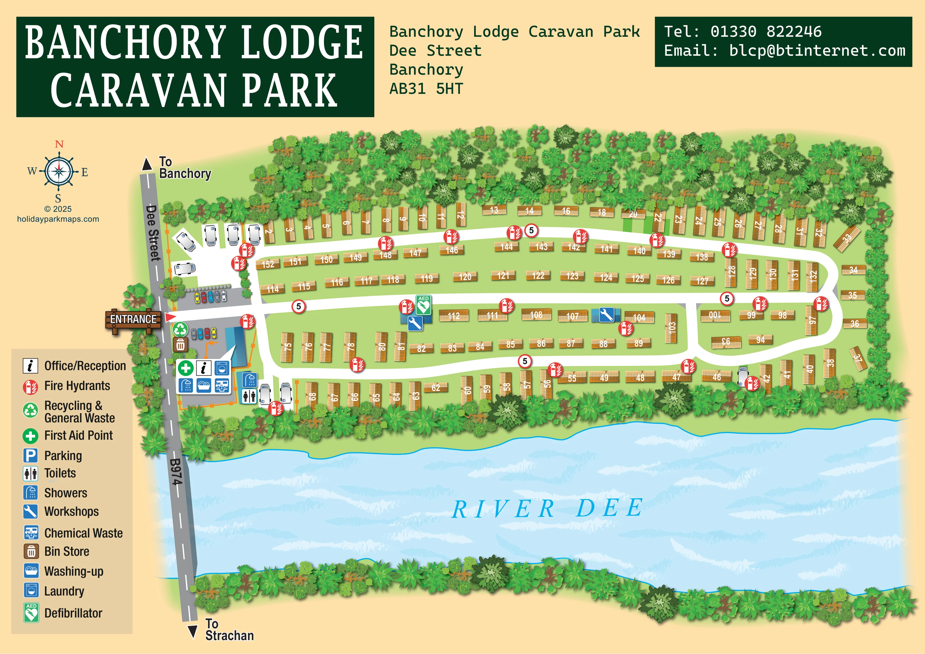
The prominently labelled River Dee runs across the southern side of the composition, directly below the park.
ILLUSTRATED PARK MAP · P014
Banchory Lodge Caravan Park, Dee Street, Banchory · United Kingdom
 Enlarge the map ↗
A SENSE OF THE PLACE
Banchory Lodge Caravan and Motorhome Park is a small family-run site in Banchory, Royal Deeside. It combines privately owned static caravans with fully serviced hardstanding pitches for motorhomes and campervans.
The town's shops and places to eat can be reached on foot, and local bus services offer a way to explore Deeside. Wet rooms and toilets serve touring visitors. The park's touring provision is specifically for motorhomes and campervans.
LOOK CLOSER
The prominently labelled River Dee runs across the southern side of the composition, directly below the park.
Dense illustrated tree belts surround the accommodation area and line both banks of the river.
An information symbol identifies reception within the entrance-side service cluster.
Toilet and shower symbols appear beside the motorhome pitches south of the entrance; a further shower symbol appears in the main service callout.
A washing-machine symbol is included in the entrance-side facilities callout.
A washing-up symbol is grouped with reception and other visitor facilities near the entrance.
The chemical-waste symbol appears in the entrance-side service callout.
Recycling and bin-store symbols mark the western arrival and service area.
An information symbol identifies reception within the entrance-side service cluster.
Toilet and shower symbols appear beside the motorhome pitches south of the entrance; a further shower symbol appears in the main service callout.
A washing-machine symbol is included in the entrance-side facilities callout.
A washing-up symbol is grouped with reception and other visitor facilities near the entrance.
The chemical-waste symbol appears in the entrance-side service callout.
Recycling and bin-store symbols mark the western arrival and service area.
A green first-aid cross is shown in the main entrance-side facilities cluster.
A green AED symbol marks a central building beside a workshop symbol.
Repeated red circular fire-hydrant symbols are distributed along the internal roads and accommodation rows.
Blue spanner symbols identify two buildings within the central accommodation area.
Small cars on grey paved areas depict parking on both sides of the entrance approach. Parking also has an entry in the legend.
The prominently labelled River Dee runs across the southern side of the composition, directly below the park.
Dense illustrated tree belts surround the accommodation area and line both banks of the river.
A timber-style ENTRANCE sign and red pointer mark the western access from Dee Street.
The grey road along the western edge is labelled Dee Street and B974, crossing the river with arrows towards Banchory and Strachan.
Broad white lanes connect long accommodation strips, turn around their eastern ends and link through short cross-roads.
Red-bordered circular signs bearing 5 repeat at several points on the internal roads; no unit is printed.
READING THE MAP
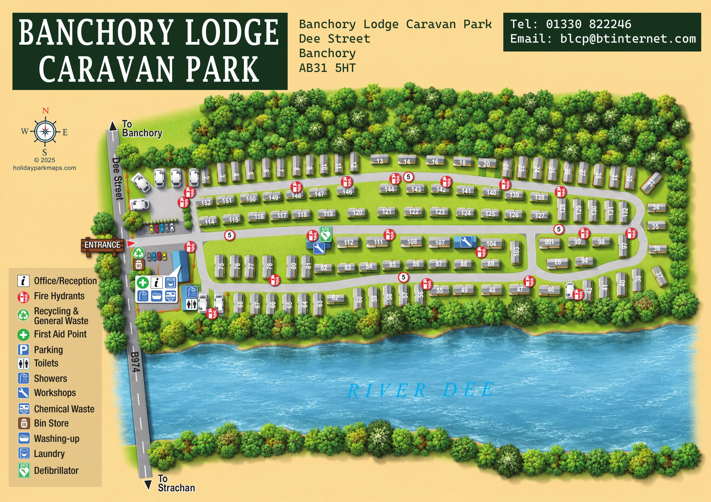
The River Dee gives this illustrated map of Banchory Lodge Caravan Park its defining shape. Set on Dee Street in Banchory, Royal Deeside, the park is shown as a long, tree-framed site with rows of static caravans following linked internal roads. A smaller motorhome area sits close to the western entrance and the main visitor facilities.
The artwork combines practical arrival information with a strong sense of the riverside setting. Dee Street and the B974 form a clear landmark at the left of the plan, with arrows towards Banchory and Strachan. Reception, showers, laundry, washing-up and waste facilities are brought together near the entrance, while a pictorial key explains the symbols used throughout the site.
Golden caravan roofs, white roads and richly layered green trees make the accommodation layout distinct from the broad blue river below. The dark-green heading and contact panels complete a landscape-format design that suits a park needing both numbered-unit wayfinding and a recognisable illustration of its surroundings.
This single landscape-format plan places the accommodation area across the middle of the page, with the River Dee sweeping beneath it. Dee Street runs down the western edge and continues across the river as the B974. Bold arrows indicate the directions to Banchory and Strachan, while a timber-style entrance sign and red pointer identify the park access.
From that entrance, broad white roads lead east through long, green accommodation strips. Rounded turns at the far end and short cross-links make the connected circulation pattern easy to follow. Static caravans are illustrated as golden roof shapes, sometimes parallel to the road and sometimes end-on, with white numbers placed directly over them. A small group of motorhome illustrations appears on pale individual pitches near the entrance, with further vehicles beside the southern service area and riverside row.
The western arrival cluster includes illustrated car parking and a blue-roofed service building. A white callout groups reception, first aid, laundry, showers, washing-up and chemical-waste symbols. Nearby symbols identify recycling, a bin store, toilets and additional showers. Two workshop symbols appear within the central strips, and a green defibrillator marker identifies one of these building locations. Red fire-hydrant symbols and circular 5 road markers recur along the lanes.
A vertical legend in the lower-left margin explains the facilities, and a compass rose sits above it. Dense, overlapping tree crowns frame the park and both riverbanks. Pale streaks texture the water, beneath a large italic River Dee label. Across the top, the park name, address and contact panels remain separate from the working plan, preserving space for the numbered accommodation and landscape.
 Enlarge this map ↗
KEEP EXPLORING
Chosen for shared landscapes, accommodation or facilities.
 Explore the map ↗
United Kingdom
A lakeside holiday-park and fishery map with numbered accommodation, fishing positions and clearly grouped visitor services.
 Explore the map ↗
United Kingdom
Wooded holiday-home park map with River Severn context, seasonal pitches and a clearly defined arrival area.
 Explore the map ↗
Spain
Wooded campsite map with a river-crossing approach, curved touring rows, lodges and paired outdoor pools.
Features may come from the sample artwork, its key or published park information. Approximate numbers describe the drawing and may cover only part of a park. They are intended to help you compare map examples. Current facilities and booking information should be checked with the park.
LET’S MAP YOUR PARK
For a map quotation, find your park and draw a rough boundary around it. The area you select helps us work out the design time and price.
Draw your park for a quote ↗Or talk to our map designers
01751 473136