
River Severn
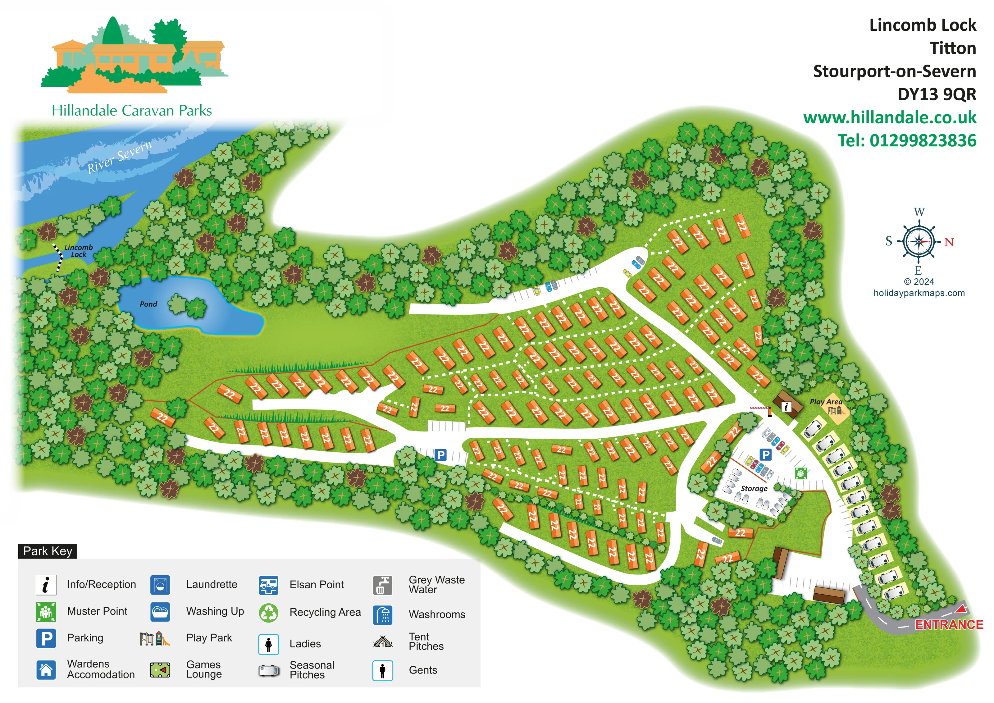
A broad blue river crosses the upper-left edge, with its name set diagonally over pale water markings.
ILLUSTRATED PARK MAP · P190
Lincomb Lock, Titton, Stourport-on-Severn · United Kingdom
 Enlarge the map ↗
A SENSE OF THE PLACE
Lincomb Lock Caravan Park offers holiday home plots across landscaped terraces and meadows overlooking the Severn Valley. Some homes have private gardens, while other plots are maintained by the park.
An adults-only touring area accommodates caravans, motorhomes and trailer tents, with electricity and water connections. The map shows the relationship between these areas and the park's sloping countryside setting.
LOOK CLOSER
A broad blue river crosses the upper-left edge, with its name set diagonally over pale water markings.
The lock is named beside a narrow blue channel and a small black-and-white crossing-like graphic on the left of the plan.
An irregular blue pond with a small tree-covered island sits within the wooded western part of the park.
Dense tree belts enclose much of the site, frame the river and pond, and separate some accommodation groups. Open grass and clipped hedge-like graphics appear between the western rows.
A red arrow and large ENTRANCE label mark the arrival road at the lower-right edge.
Broad white roads branch and loop through the holiday-home areas; narrower white dashed routes thread between individual rows.
An information symbol marks a brown building beside the play area and the junction above the storage compound.
A labelled Play Area with illustrated play equipment occupies a small yellow-green space beside reception.
A broad blue river crosses the upper-left edge, with its name set diagonally over pale water markings.
The lock is named beside a narrow blue channel and a small black-and-white crossing-like graphic on the left of the plan.
An irregular blue pond with a small tree-covered island sits within the wooded western part of the park.
Dense tree belts enclose much of the site, frame the river and pond, and separate some accommodation groups. Open grass and clipped hedge-like graphics appear between the western rows.
A red arrow and large ENTRANCE label mark the arrival road at the lower-right edge.
Broad white roads branch and loop through the holiday-home areas; narrower white dashed routes thread between individual rows.
An information symbol marks a brown building beside the play area and the junction above the storage compound.
A labelled Play Area with illustrated play equipment occupies a small yellow-green space beside reception.
Blue P symbols identify parking near the central western road junction and within the entrance-side service area; additional marked bays appear along roads.
A labelled Storage compound contains closely arranged pale caravan symbols, distinct from the seasonal pitch row.
A green assembly-point symbol is positioned beside the parking and storage area.
The key includes washroom, ladies and gents symbols; their individual locations are not clearly marked in the visible plan.
Both services are represented in the key without clearly identifiable placements on the plan.
The key provides separate symbols for chemical toilet disposal and grey waste water.
A green recycling symbol appears in the key, but its location is not clearly shown.
A house symbol identifies wardens' accommodation in the key only.
A billiard-table pictogram appears in the key for a games lounge, without a clearly visible corresponding marker on the plan.
Tent pitches are listed in the key, but no distinct tent-pitch area or count can be inferred from the artwork.
READING THE MAP
This illustrated map of Lincomb Lock Caravan Park places its holiday-home layout within a wooded setting beside the River Severn at Titton, near Stourport-on-Severn. The river, named lock and an irregular pond give the plan a recognisable landscape context, while orange accommodation symbols stand out against textured green grounds.
The entrance is clearly marked at the lower right, leading past a separate row of seasonal caravan pitches towards parking, caravan storage, reception and the play area. From this arrival cluster, broad white roads branch across the park into staggered rows and curved groups of holiday homes. Smaller dashed routes help explain connections within those groups without competing with the main road network.
Hillandale Caravan Parks branding, a substantial pictorial key and a rotated compass complete the page. The sample is particularly relevant to landscaped holiday-home parks that need to show both a sizeable accommodation layout and the relationship between arrival facilities, quieter residential areas and surrounding water or woodland.
The single landscape-format plan follows the park's irregular outline, stretching from the entrance at the lower right to the River Severn and Lincomb Lock at the upper left. A dense belt of illustrated trees encloses much of the accommodation and continues around the river channel and pond. The pond is a distinctive blue shape with a small wooded island, set beside a comparatively open grassed area on the western side.
Most holiday homes are shown as orange roof shapes arranged along a network of broad white roads. Western branches serve two long rows, while the central and upper-right areas contain staggered groups connected by dashed white routes. A curved lower road encloses another landscaped accommodation group. Changes in unit orientation, planting and road alignment make the different sections legible without relying on separate inset plans.
Arrival facilities are concentrated towards the right. A pale caravan row follows the boundary beside the entrance road, and a separate compound is explicitly labelled Storage. Blue parking markers and fine bay lines identify parking areas. Reception is marked on a brown building beside the labelled play area, while a green muster-point symbol sits near the storage and parking cluster.
The lower-left key explains accommodation and service symbols, including seasonal and tent pitches, washrooms, laundry, washing up and waste disposal. Several of these appear in the key rather than as clearly placed markers within the plan. The upper page carries Hillandale branding and the park's address, while the compass occupies open space on the right. The accompanying enlargements repeat the key and entrance corner for legibility; they are details of this same artwork, not additional park sections.
KEEP EXPLORING
Chosen for shared landscapes, accommodation or facilities.
 Explore the map ↗
United Kingdom
A lakeside holiday-park and fishery map with numbered accommodation, fishing positions and clearly grouped visitor services.
 Explore the map ↗
United Kingdom
A woodland estate park map combining caravan loops, touring pitches, riverside paths and Bruce’s Cave landmarks.
 Explore the map ↗
United Kingdom
Woodland holiday-park map with named accommodation areas, touring loops and illustrated recreation facilities.
Features may come from the sample artwork, its key or published park information. Approximate numbers describe the drawing and may cover only part of a park. They are intended to help you compare map examples. Current facilities and booking information should be checked with the park.
LET’S MAP YOUR PARK
For a map quotation, find your park and draw a rough boundary around it. The area you select helps us work out the design time and price.
Draw your park for a quote ↗Or talk to our map designers
01751 473136