
River Kirtle
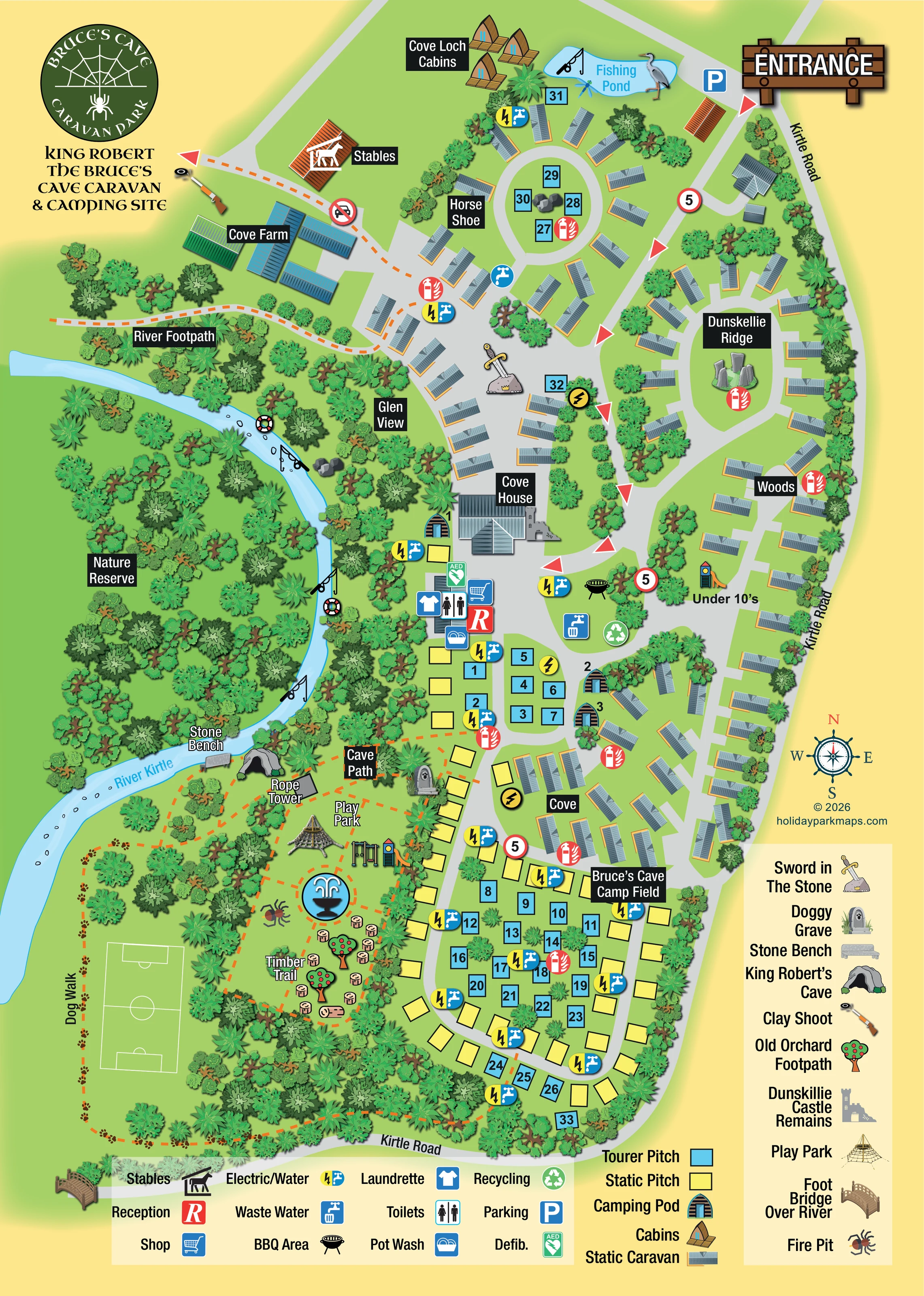
The named pale-blue river curves down the western side of the estate through dense woodland, with fishing-rod and lifebuoy illustrations along its course.
ILLUSTRATED PARK MAP · P180
Cove Estate, Kirkpatrick Fleming, Dumfriesshire · United Kingdom
 Enlarge the map ↗
A SENSE OF THE PLACE
King Robert the Bruce's Cave Caravan and Camping Site is located on the Cove Estate near Kirkpatrick Fleming. The family-run park occupies countryside associated with the cave that gives the site its name.
Camping and touring visitors can use it as a base for exploring the Solway area and south-west Scotland. The map places the accommodation areas within the estate setting and shows the routes through the grounds.
LOOK CLOSER
The named pale-blue river curves down the western side of the estate through dense woodland, with fishing-rod and lifebuoy illustrations along its course.
A large wooded area west of the river is labelled Nature Reserve.
A grey cave illustration sits beside the river and Cave Path, identified by the right-hand key as King Robert’s Cave.
Individually illustrated estate buildings provide major landmarks: Cove House in the centre and a blue-and-green-roofed farm complex to the north-west.
A large sword-in-stone illustration forms a distinctive landmark between Glen View and the main road.
A ruin illustration adjoining the Cove House area corresponds to the castle-remains symbol in the pictorial key.
A paw-marked gravestone appears beside the Cave Path, matching the Doggy Grave entry in the key.
A prominent circular blue fountain illustration acts as a visual landmark within the southern recreation grounds.
A large timber entrance sign marks the upper-right arrival point from Kirtle Road, with a blue parking symbol immediately nearby.
A central road connects curved accommodation loops and short branches. Red directional arrows and repeated circular signs marked 5 provide additional route cues.
Reception and shop symbols form part of the central service cluster below Cove House.
Three distinct symbols identify these practical facilities together in the central service area.
Repeated combined electricity-and-water symbols serve the accommodation areas; separate tap and electricity symbols also appear.
Waste-water and recycling symbols are positioned in the central road island near the service buildings.
A green AED symbol identifies a defibrillator at the central facility cluster.
Repeated red extinguisher-and-flame symbols mark points throughout the accommodation areas.
A barbecue illustration marks the central green island near the waste-water and recycling points.
The named pale-blue river curves down the western side of the estate through dense woodland, with fishing-rod and lifebuoy illustrations along its course.
A labelled pond near the entrance and Cove Loch Cabins is illustrated with a fishing rod, heron and dragonfly.
A large wooded area west of the river is labelled Nature Reserve.
Orange dashed paths link the farm-side route, riverbank, cave and southern recreation grounds.
A named route with paw-print markings runs around the western and southern edges of the recreation field.
A timber bridge illustration appears at the lower-left edge of the plan and is identified in the pictorial key as Foot Bridge Over River.
A grey cave illustration sits beside the river and Cave Path, identified by the right-hand key as King Robert’s Cave.
A labelled stone bench stands beside the river near the cave.
Individually illustrated estate buildings provide major landmarks: Cove House in the centre and a blue-and-green-roofed farm complex to the north-west.
An orange-roofed building near Cove Farm is labelled Stables and carries a horse pictogram.
A clay-shooting illustration marks the north-western edge beyond the farm and stables.
A large sword-in-stone illustration forms a distinctive landmark between Glen View and the main road.
A ruin illustration adjoining the Cove House area corresponds to the castle-remains symbol in the pictorial key.
A paw-marked gravestone appears beside the Cave Path, matching the Doggy Grave entry in the key.
The southern recreation area includes a labelled rope tower, a large rope-climbing structure, swings and a slide.
A separate small slide-and-tower illustration is labelled Under 10’s beside the eastern accommodation roads.
A labelled activity area uses illustrated timber stepping stumps and a log beneath orchard-tree symbols.
Fruit-tree symbols in the southern walking and activity area correspond to Old Orchard Footpath in the key.
A stylised symbol west of the circular fountain matches the Fire Pit entry in the pictorial key.
A prominent circular blue fountain illustration acts as a visual landmark within the southern recreation grounds.
White football-pitch markings occupy the open grass area inside the dog-walk circuit.
Rock illustrations occupy the Horse Shoe island and riverbank, while a standing-stone group distinguishes the centre of Dunskellie Ridge.
READING THE MAP
This illustrated map brings together the caravan and camping areas of King Robert the Bruce’s Cave Caravan & Camping Site with the wooded grounds of Cove Estate in Dumfriesshire. Rather than treating the park as a collection of pitches alone, it gives the River Kirtle, nature reserve, cave and walking routes a substantial place in the picture.
Accommodation follows a series of named road loops, including Horse Shoe, Dunskellie Ridge and Cove. Blue touring pitches and yellow static pitches are clearly distinguished from the roof illustrations used for static caravans, while small groups of camping pods and Cove Loch Cabins add further variety. Reception, washing facilities and other practical services gather around a central hub near Cove House.
The estate’s more unusual landmarks make this a particularly characterful sample: a sword in the stone, castle remains, a riverside stone bench and the cave itself all have recognisable illustrations. Play areas, a timber trail, a football field and a paw-marked dog walk extend the map’s purpose from arrival guidance to exploring the grounds.
The portrait plan is organised around an upper-right entrance from Kirtle Road. A broad grey internal road leads into a network of loops and branches, with red arrows and repeated signs marked 5 providing route cues. Static caravans line the roads through Horse Shoe, Glen View, Dunskellie Ridge, Woods and Cove. Bruce’s Cave Camp Field occupies the southern end, combining numbered blue tourer pitches with yellow static-pitch rectangles. Three camping pods sit near the central roads, while the pointed-roof Cove Loch Cabins overlook a fishing pond near the entrance.
Cove House provides a central landmark above the reception and service cluster. Symbols identify the shop, toilets, laundrette, pot wash and defibrillator, with waste-water disposal, recycling and a BBQ area nearby. Electricity and water points recur throughout the accommodation areas. Cove Farm and the stables occupy the north-western part of the plan, with a clay-shoot illustration beyond them.
The western landscape is dominated by the River Kirtle and richly textured woodland, including a labelled nature reserve. Orange dashed routes identify the River Footpath and Cave Path and connect the riverside cave and stone bench with the southern recreation grounds. Here, the map shows a rope tower, climbing structure, swings, slide, fountain, fire pit and timber trail. A separate Under 10’s play area appears beside the eastern roads. The dog walk, marked with paw prints, circles the grass football field.
A lower service key and accommodation key explain the practical symbols, while a tall right-hand key identifies landmarks such as the sword in the stone, Doggy Grave and castle remains. The circular spider-and-web logo, formal title and illustrated timber entrance sign complete the single-page composition.
KEEP EXPLORING
Chosen for shared landscapes, accommodation or facilities.
 Explore the map ↗
United Kingdom
Woodland-framed Barnsoul map with mixed accommodation, shared facilities and paw-marked walking routes.
 Explore the map ↗
United Kingdom
Portrait park map with mixed touring pitches, seasonal rows, ponds and an extensive dog walk.
 Explore the map ↗
United Kingdom
Trevornick’s colour-coded park map, with mixed accommodation, fishing ponds, golf and wooded trails.
Features may come from the sample artwork, its key or published park information. Approximate numbers describe the drawing and may cover only part of a park. They are intended to help you compare map examples. Current facilities and booking information should be checked with the park.
LET’S MAP YOUR PARK
For a map quotation, find your park and draw a rough boundary around it. The area you select helps us work out the design time and price.
Draw your park for a quote ↗Or talk to our map designers
01751 473136