
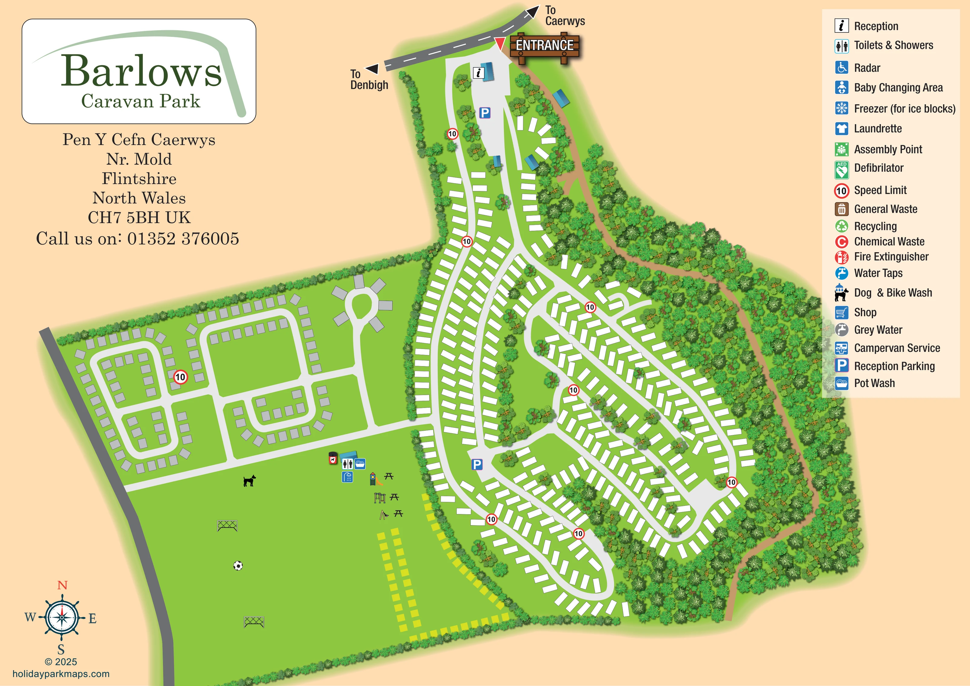
Wooded eastern boundary
Dense, overlapping tree canopies form a broad belt around the eastern and south-eastern edges.
ILLUSTRATED PARK MAP · P017
Penycefn Road, Caerwys, Mold · United Kingdom
 Enlarge the map ↗
A SENSE OF THE PLACE
Barlows Caravan Park lies in a wooded valley at Caerwys in North Wales. The family-run park combines static holiday home ownership with touring caravan and motorhome pitches.
A shop, launderette and washrooms provide everyday facilities, with seasonal events adding to the social side of the park. The setting places visitors within reach of the North Wales countryside and coast. Tent camping is not offered.
LOOK CLOSER
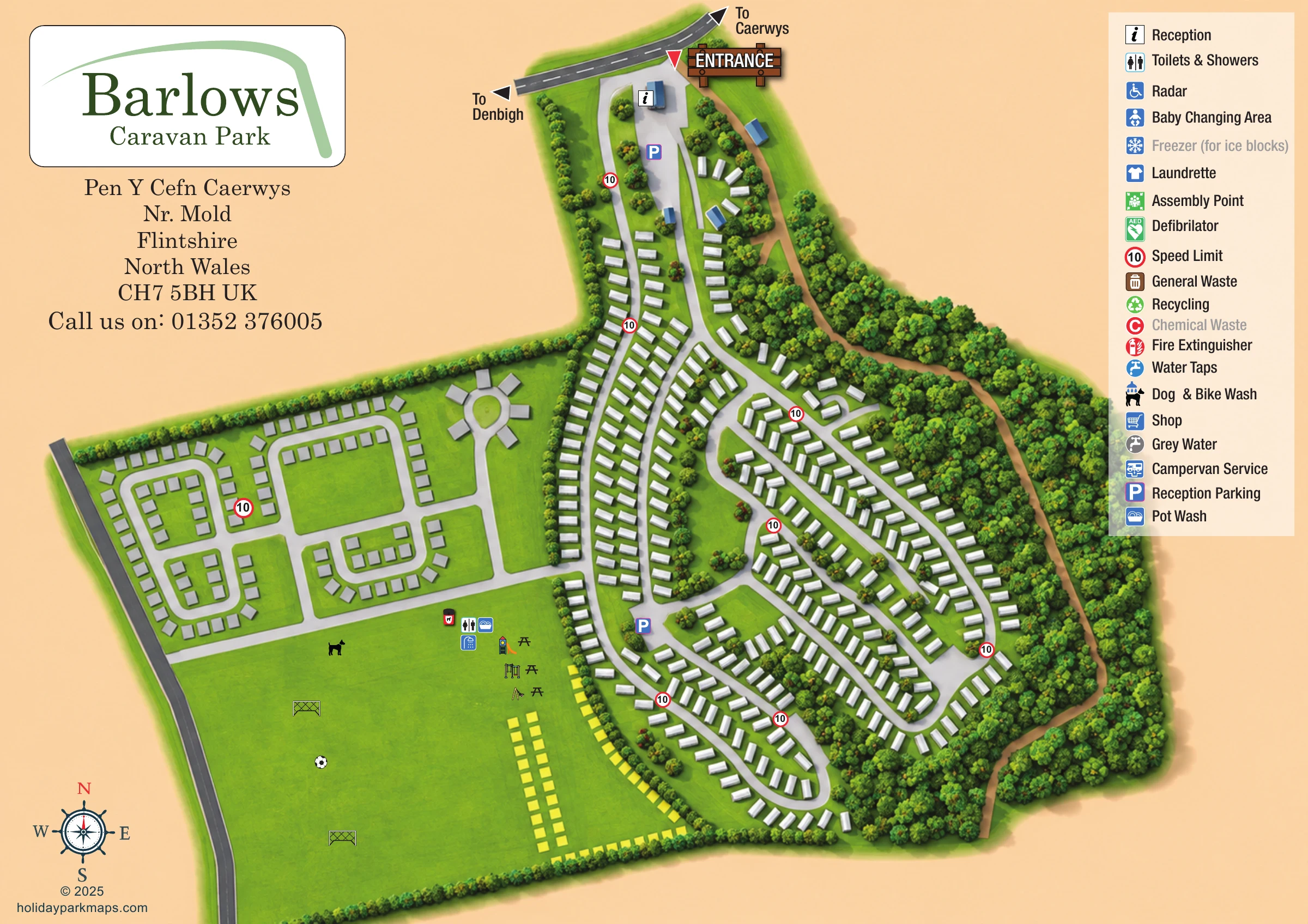
Dense, overlapping tree canopies form a broad belt around the eastern and south-eastern edges.
Narrow planted boundaries enclose the western and southern areas, while shrubs and tree clusters break up the accommodation rows.
A prominent timber-style ENTRANCE sign and red triangular marker identify the arrival point at the top of the plan.
Black arrowheads label the two directions along the grey public road outside the entrance.
An information symbol marks a blue-roofed building immediately inside the entrance.
Blue P symbols appear on the entrance forecourt and at a central road junction. The legend calls this symbol Reception Parking.
Toilet and shower symbols identify the blue-roofed amenity building beside the southern recreation field.
A blue pot-wash symbol is placed beside the washroom building.
A prominent timber-style ENTRANCE sign and red triangular marker identify the arrival point at the top of the plan.
Black arrowheads label the two directions along the grey public road outside the entrance.
An information symbol marks a blue-roofed building immediately inside the entrance.
Blue P symbols appear on the entrance forecourt and at a central road junction. The legend calls this symbol Reception Parking.
Toilet and shower symbols identify the blue-roofed amenity building beside the southern recreation field.
A blue pot-wash symbol is placed beside the washroom building.
A slide, climbing or activity frame and swing equipment form a small play area beside the amenity building.
Several black picnic-table illustrations sit alongside the play equipment.
A large open green field is illustrated with two goals and a football.
A black dog silhouette appears on the open field, with a dog-waste-style bin beside the amenity building. The field is not explicitly labelled as a dog exercise area.
Dense, overlapping tree canopies form a broad belt around the eastern and south-eastern edges.
Narrow planted boundaries enclose the western and southern areas, while shrubs and tree clusters break up the accommodation rows.
A tan route runs from near the entrance through the eastern tree belt and towards the bottom of the plan, with a short branch near its northern end.
Pale roads connect the entrance spine, eastern curved loops, western rectangular loops and small circular turning head.
Repeated red-ringed 10 signs punctuate the internal roads.
A shopping-trolley symbol is included in the key; its position is not clearly marked on the plan.
Listed with a blue clothing symbol in the key, without a clearly identifiable placement.
An ice-block freezer is named in the key.
The legend includes a baby-changing symbol, but does not establish its location.
The key labels a wheelchair symbol Radar. No location or accessibility specification is established by this entry alone.
A dog beneath a shower symbol is keyed as Dog & Bike Wash; the plain dog silhouette on the field is a different graphic.
The key includes water taps, chemical waste, grey water, general waste and recycling, without clearly visible placements for these keyed symbols.
A campervan service symbol is listed in the key.
Fire extinguisher, defibrillator and assembly point symbols appear in the legend; their positions are not clearly identified on the plan.
READING THE MAP
This illustrated map of Barlows Caravan Park presents a large mixed caravan park in the wooded surroundings of Caerwys, North Wales. Its most recognisable feature is the contrast between the closely arranged caravan rows on the eastern side and the more spacious pitch loops and recreation field to the west and south. A richly drawn belt of trees wraps around the right-hand boundary, with a tan path threading through the planting.
Arrival is easy to spot: a timber-style entrance sign sits beside the road directions to Caerwys and Denbigh, followed by reception and parking. Pale internal roads then carry the eye through the park's branching loops. Near the open field, small illustrations show football goals, children's play equipment and picnic tables, with toilets, showers and pot washing marked at the adjacent building.
The page combines a practical overhead plan with selective pictorial detail. Large park branding occupies the upper-left corner, while a tall facility key balances the composition on the right. It is a useful sample for parks that need to explain a substantial, varied layout without filling the main plan with text.
The single landscape-format map is organised around a narrow entrance at the top of the page. A dark grey public road carries arrows towards Caerwys and Denbigh, and a large illustrated entrance board marks the turn into the park. Just inside, the reception information symbol sits over a small blue-roofed building, with parking shown on the pale forecourt below.
The internal road network expands into two contrasting arrangements. Across the centre and east, long rows of white rectangular units follow a main spine and several curved branches. Rounded loop ends and angled footprints give these areas a flowing pattern. To the west, grey rectangles surround more regular road loops, with broad green spaces between them and a small circular turning head near the upper boundary. Yellow rectangles outline parts of the southern field. These colours distinguish groups visually, although the facility legend does not define their accommodation types.
The open southern area provides a clear landmark within the denser site plan. Two football goals and a ball indicate recreational use, while a slide, other play equipment and picnic tables cluster near the amenity building. Toilet, shower and pot-wash symbols identify that building. A dog silhouette and a dog-waste-style bin add further field-side detail without an explicit area label.
Dense illustrated woodland encloses the eastern edge, where a separate tan path winds towards the bottom of the page. A tall key lists everyday facilities, servicing and safety symbols; some are positioned on the plan, while others appear only in the key. The large logo, stacked contact block and lower-left compass complete the page. The enlarged views show overlapping portions of this same artwork, not separate sections or additional sites.
 Enlarge this map ↗
KEEP EXPLORING
Chosen for shared landscapes, accommodation or facilities.
 Explore the map ↗
United Kingdom
A wooded Allerton park plan with colour-coded neighbourhoods, touring pitches and a central facilities hub.
 Explore the map ↗
United Kingdom
A wooded, streamside park map with a linked farm, café, touring and cottage area.
 Explore the map ↗
United Kingdom
Woodland holiday-park map with named accommodation areas, touring loops and illustrated recreation facilities.
Features may come from the sample artwork, its key or published park information. Approximate numbers describe the drawing and may cover only part of a park. They are intended to help you compare map examples. Current facilities and booking information should be checked with the park.
LET’S MAP YOUR PARK
For a map quotation, find your park and draw a rough boundary around it. The area you select helps us work out the design time and price.
Draw your park for a quote ↗Or talk to our map designers
01751 473136