
Tree-lined stream
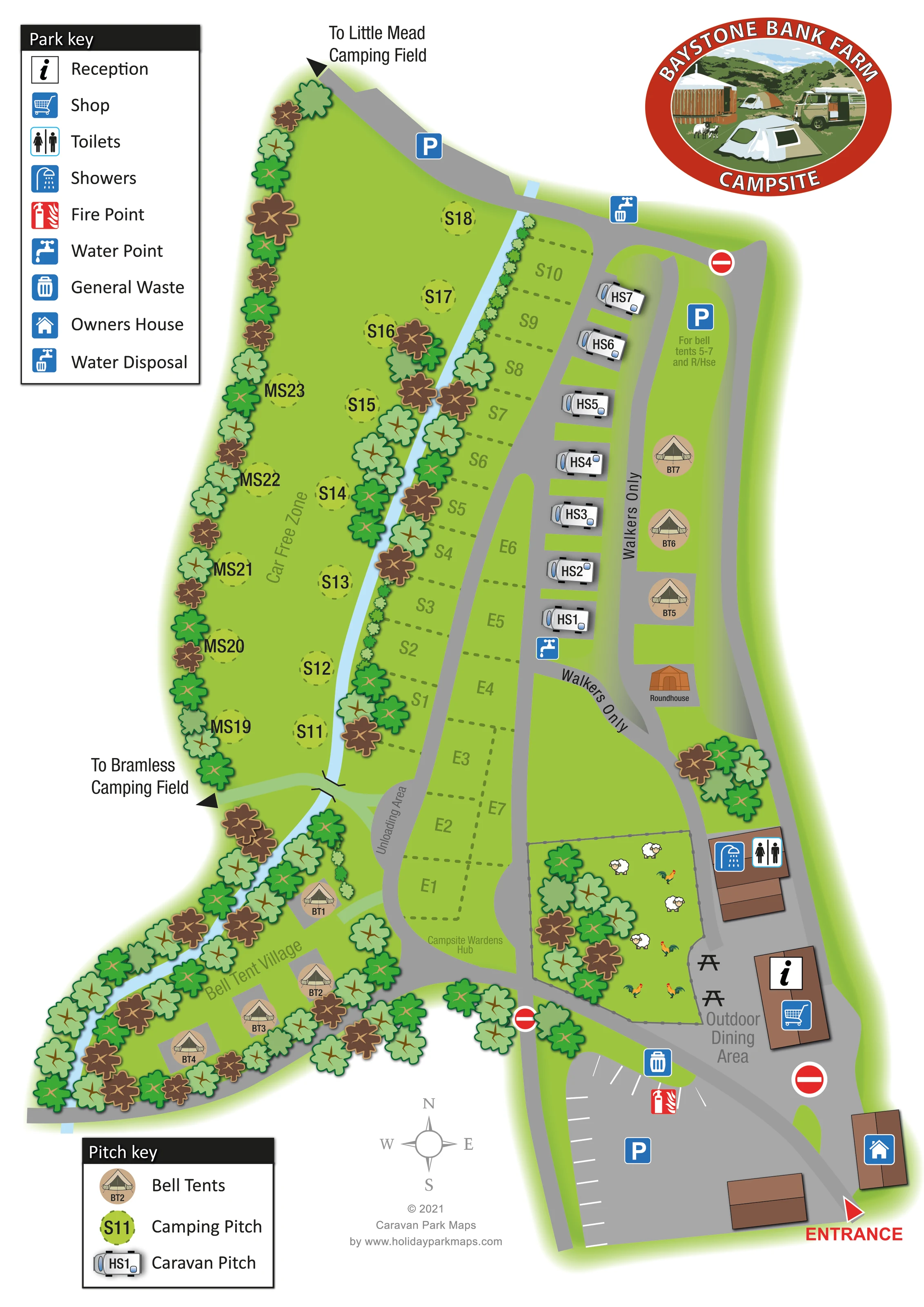
A narrow pale-blue watercourse runs through the western side of the campsite, separating the car-free camping area from central pitches before passing the Bell Tent Village.
ILLUSTRATED PARK MAP · P403
Baystone Bank Farm, Whicham, Millom, Cumbria · United Kingdom
 Enlarge the map ↗
A SENSE OF THE PLACE
Baystone Bank Farm Campsite lies in the Whicham Valley in the south-western Lake District. The working farm offers camping and hardstanding pitches alongside a range of cabins, pods and other glamping accommodation.
Heavy horses, riding experiences and farm life give the site its character. A shop and washroom facilities support campers, while selected glamping properties include private hot tubs. Silecroft Beach and the surrounding fell country provide contrasting landscapes for days out.
LOOK CLOSER
A narrow pale-blue watercourse runs through the western side of the campsite, separating the car-free camping area from central pitches before passing the Bell Tent Village.
Repeated green and brown tree crowns frame the western boundary, watercourse and bell tents, with smaller clusters around the central facilities.
A fenced area near reception contains sheep and poultry illustrations, conveying the farm setting without identifying a formal visitor attraction.
Reception and shopping symbols share a brown-roofed building near the entrance and outdoor dining area.
A separate building immediately north of reception carries toilet and shower symbols.
A labelled area with picnic-table symbols sits beside reception and the illustrated animal enclosure.
A water point is marked near the southern end of the caravan row, general waste near the main car park, and water disposal beside the northern road.
A red fire-point symbol is positioned beside the main parking area.
Reception and shopping symbols share a brown-roofed building near the entrance and outdoor dining area.
A separate building immediately north of reception carries toilet and shower symbols.
A labelled area with picnic-table symbols sits beside reception and the illustrated animal enclosure.
A water point is marked near the southern end of the caravan row, general waste near the main car park, and water disposal beside the northern road.
A red fire-point symbol is positioned beside the main parking area.
Parking is marked at the southern arrival area and northern approach. An eastern parking symbol is accompanied by a note for nearby bell tents and the roundhouse.
A house symbol identifies a building beside the entrance on the eastern side.
The hub is labelled at the southern end of the central camping-pitch strip, without a separate facility icon.
A narrow pale-blue watercourse runs through the western side of the campsite, separating the car-free camping area from central pitches before passing the Bell Tent Village.
Repeated green and brown tree crowns frame the western boundary, watercourse and bell tents, with smaller clusters around the central facilities.
A fenced area near reception contains sheep and poultry illustrations, conveying the farm setting without identifying a formal visitor attraction.
A large red entrance label and triangular pointer mark arrival at the bottom-right corner.
The western grass camping area is explicitly labelled Car Free Zone.
Routes beside the eastern glamping strip and towards the central facilities are labelled Walkers Only. A pale-green path crosses the stream towards Bramless Camping Field.
An unloading area is labelled beside the central road near the route into the western camping and bell-tent areas.
Red no-entry symbols punctuate several internal junctions; they are part of the artwork's vehicle-routing information.
Off-plan arrows identify Little Mead Camping Field to the north and Bramless Camping Field to the west.
READING THE MAP
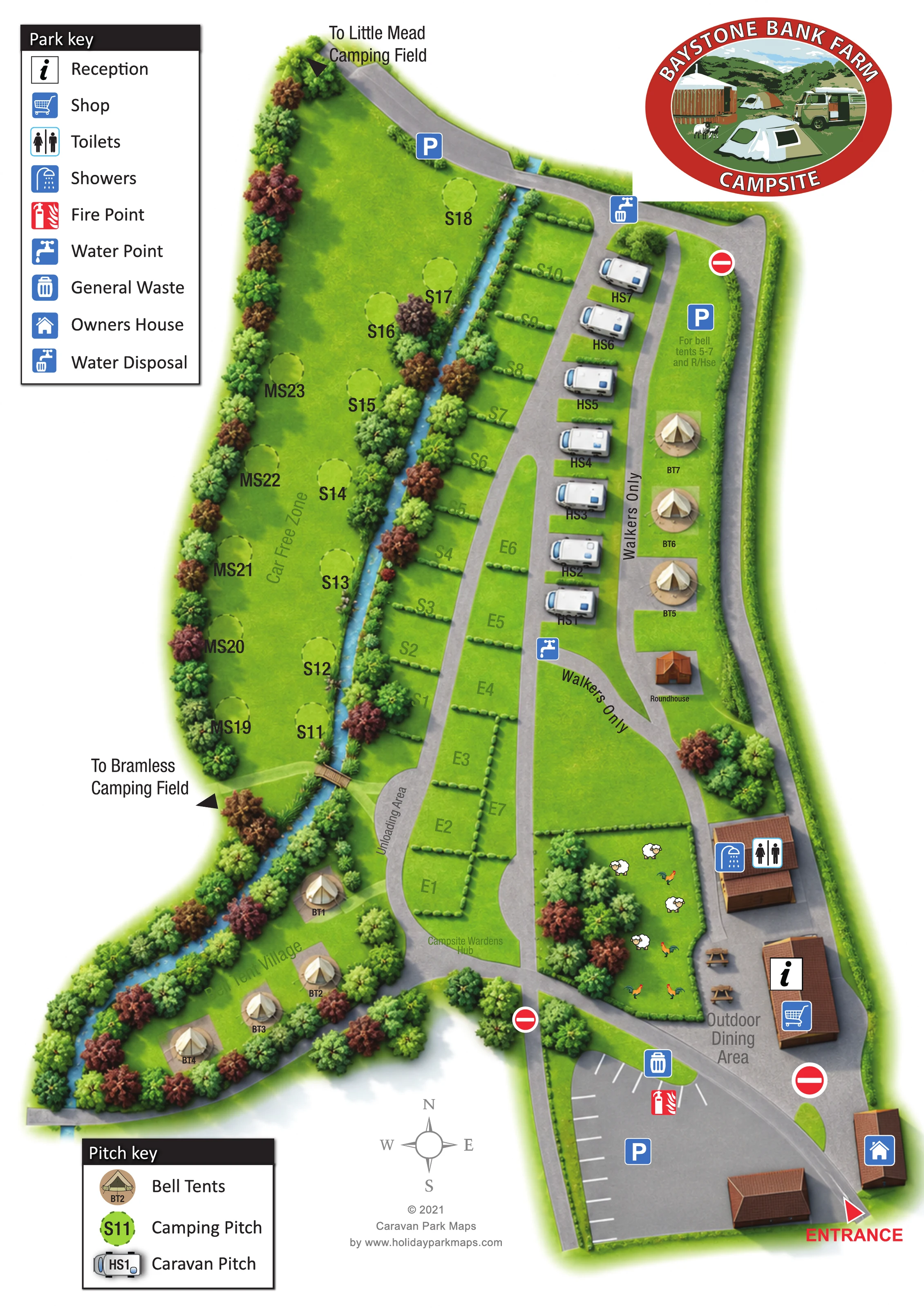
This illustrated map of Baystone Bank Farm Campsite presents a farm campsite in Cumbria's Whicham Valley, on the south-western side of the Lake District. Its elongated layout brings together grass camping, a short row of caravan hardstandings and two distinct bell-tent areas, with a tree-lined stream providing a strong visual thread through the plan.
The artwork gives particular attention to how visitors move between these different spaces. A clearly marked entrance leads into the main parking and reception area, while the western camping field is labelled as car-free and selected links are marked for walkers only. The Bell Tent Village occupies a wooded branch beside the stream; another group of tents and a roundhouse sits on the eastern side.
Blue service symbols identify the shop, washrooms, water and waste points, and a labelled outdoor dining area sits beside an illustrated enclosure of sheep and poultry. Separate facility and pitch keys make this a useful sample for campsites that need practical arrival information alongside a recognisable rural character.
The portrait plan is arranged around a southern arrival area and a network of grey roads extending north. A red entrance pointer marks the lower-right corner beside the owners' house. The main car park, reception and shop are grouped close together, with toilets and showers in a separate building just above them. Picnic-table symbols identify the outdoor dining area, next to a fenced space illustrated with sheep and poultry. A fire point and general-waste symbol sit near the parking area.
Accommodation is organised into visibly different zones. Central grass pitches use dotted boundaries and lettered references, while the caravan hardstandings form a compact row of overhead caravan illustrations. Across the pale-blue stream, circular camping markers occupy a broader tree-bordered field labelled Car Free Zone. An unloading area is marked beside the road, near a pale-green path that crosses the watercourse.
The south-western branch contains the labelled Bell Tent Village, with individual beige tent illustrations tucked between the stream and wooded edges. A second group of bell tents occupies the eastern strip beside a small illustrated roundhouse. Walkers Only labels distinguish pedestrian links here, and a parking note relates to these nearby glamping units. Water and water-disposal symbols appear along the central and northern routes, while the campsite wardens' hub is named near the southern pitches.
Arrows lead beyond the plan to Little Mead and Bramless camping fields. Two black-headed keys explain facilities and accommodation, and a compass supports orientation. The large oval farm-and-camping logo balances the upper-left legend. The detail views enlarge this same single-page design rather than showing separate campsite sections.
 Enlarge this map ↗
KEEP EXPLORING
Chosen for shared landscapes, accommodation or facilities.
 Explore the map ↗
United Kingdom
Woodland park map with mixed pitches, bell tents, lodges and a fishing lake.
 Explore the map ↗
United Kingdom
Woodland holiday homes, named camping fields and farm buildings on a colour-coded Nether Wasdale park map.
 Explore the map ↗
United Kingdom
Illustrated caravan park plan with woodland and riverside walks, fishing pools and wildlife panels.
Features may come from the sample artwork, its key or published park information. Approximate numbers describe the drawing and may cover only part of a park. They are intended to help you compare map examples. Current facilities and booking information should be checked with the park.
TAKE A CLOSER LOOK
View the illustrated map in detail or choose a file to download. These are sample maps; contact the park for current visitor information.

LET’S MAP YOUR PARK
For a map quotation, find your park and draw a rough boundary around it. The area you select helps us work out the design time and price.
Draw your park for a quote ↗Or talk to our map designers
01751 473136
 baystonebanklargearea_large.png